Crop Monitor for Early Warning
Report Information
No. 110: Published November 6th 2025
Conditions as of October 28th
For access to all reports, please visit the Archive.
Please visit the Referencing Guidelines page for information on how to cite the Crop Monitor reports and products.
Overview
Overview:
In East Africa, earlier dry conditions followed by recent rains and flooding are impacting parts of the north, and rainfall delays and deficits for the start of the second season in the south are forecast to continue.
In West Africa, harvesting of main season cereals is nearing completion, and good rainfall outcomes are expected to result in favourable yields in non-conflict affected areas.
In the Middle East & North Africa, dry conditions are disrupting wheat planting and are expected to continue in many areas through November, followed by a possible shift to near-average amounts.
In Southern Africa, overall conditions are favourable for the start of the main summer cropping season, and wheat yields are expected to be near to above average, except in southwestern South Africa.
In Central & South Asia, end of season conditions are favourable for spring wheat with recent improvement in northern Kazakhstan, and start of season conditions are favourable for winter wheat.
In Southeast Asia, conditions remain mostly favourable for dry-season rice and maize in the south and wet-season rice and maize in the north, except in northern Viet Nam.
In Central America & the Caribbean, erratic rains and hot temperatures are hindering Segunda/Postrera planting and development in Guatemala.
Crop Conditions at a Glance
Crop condition map synthesizing information for all Crop Monitor for Early Warning crops as of October 28th. Crop conditions over the main growing areas are based on a combination of inputs including remotely sensed data, ground observations, field reports, national, and regional experts. Regions that are in other than favourable conditions are labeled on the map with a symbol representing the crop(s) affected.
EAST AFRICA: Harvesting of main/Meher season cereals is underway in the north with concern in several regions as rainfall delays and deficits were followed by a shift to heavy rains during short periods that triggered flooding. Planting and development of second season cereals is underway in the south with concern as below-average rains are expected to continue for the October to December season (See Regional Alert Pg. 7).
WEST AFRICA: Harvesting of main season cereals is complete or nearing completion in all countries, and yields are mostly expected to be near average due to good rainfall amounts and distribution this season and despite localized flooding. However, yields in conflict areas are expected to remain below the pre-conflict average.
MIDDLE EAST & NORTH AFRICA: Planting of the 2025/26 wheat crop is just beginning with concern in most areas due to early season dryness, except in Tunisia. Dry conditions are expected to continue through November, followed by a possible shift to near-average amounts in the subsequent months.
SOUTHERN AFRICA: Start of season conditions are favourable for the 2025/26 main summer cropping season, and wetter than normal conditions are expected through early November (See Regional Outlook Pg. 11). Wheat harvesting is nearing completion with favourable to exceptional yield outcomes expected, except in the Western Cape of South Africa.
CENTRAL & SOUTH ASIA: Spring wheat harvesting finalized under favourable conditions with a noticeable improvement in northern Kazakhstan following persistent rains in September. Land preparation and planting of winter wheat are just beginning under favourable conditions, though drier than normal conditions are expected in most areas through January 2026 (See Seasonal Forecast Alert Pg. 13).
SOUTHEAST ASIA: Despite several tropical storms and significant flooding in some areas, conditions remain mostly favourable for dry-season rice and maize in the south and wet-season rice and maize in the north, except in northern Viet Nam where damage assessments are underway.
CENTRAL AMERICA & CARIBBEAN: Segunda/Postrera season cereals are developing under mostly favourable conditions, except in Guatemala where erratic precipitation and high temperatures are hindering progress. In late October, Hurricane Melissa impacted parts of eastern Cuba and Haiti.
Global Climate Outlook: Two-week forecast of areas of above or below-average precipitation
The two-week forecast (Figure 1) shows a chance of above-average precipitation over southern Mexico, Belize, Guatemala, El Salvador, Honduras, Nicaragua, northwest Colombia, central east Brazil, Sierra Leone, western Liberia, northern Côte d'Ivoire, northern Ghana, southern Democratic Republic of the Congo, southwest Angola, Zambia, Malawi, central Mozambique, northeastern Namibia, Madagascar, Lesotho, the northcentral Russian Federation, central and eastern China, southern Japan, southern Myanmar, northern Thailand, Laos, the northern Philippines, and northern Australia.
There is also a risk of below-average precipitation over northwestern Canada, the southern and eastern United States, northwestern Mexico, southwestern Colombia, northwestern Ecuador, eastern Venezuela, Guyana, Suriname, French Guiana, northern and southern Brazil, central Peru, northern Bolivia, Uruguay, northeastern Argentina, southern Chile, Portugal, western Spain, eastern France, Montenegro, Kosovo, Albania, North Macedonia, western Greece, eastern Belarus, eastern Ukraine, southwestern Romania, the western and eastern Russian Federation, western Türkiye, eastern Syria, Iraq, Iran, northern Saudi Arabia, western Morocco, eastern Cameroon, southern Chad, the Central African Republic, central South Sudan, eastern Ethiopia, Somalia, Kenya, eastern Uganda, northern Tanzania, northwestern and southeast Kazakhstan, Uzbekistan, Kyrgyzstan, Tajikistan, eastern and western Turkmenistan, Afghanistan, northern and western Pakistan, northwestern and southern India, Sri Lanka, Bangladesh, southwestern and northeastern China, eastern Mongolia, the Democratic People's Republic of Korea, western Republic of Korea, northern Japan, southern Thailand, western Malaysia, western and central Indonesia, and eastern Australia.
Figure 1: IRI SubX Precipitation Biweekly Probability Forecast for 8 – 21 November 2025, issued on 31 October 2025. The forecast is based on statistically calibrated tercile category forecasts from three SubX models. Source: IRI Subseasonal Forecasts Maproom
Climate Influences: La Niña conditions expected to continue into early 2026 and negative Indian Ocean Dipole event expected through November
La Niña conditions are present and will likely continue into early 2026. There is a 71 percent chance of La Niña conditions during November 2025 to January 2026, and a 56 percent chance during December 2025 to February 2026, according to the CPC/IRI Official ENSO Outlook. ENSO neutral conditions are likely thereafter.
La Niña typically raises the chances of below-average precipitation in eastern East Africa, central-southern Asia, southern South America, the southern United States, northern Mexico, and eastern East Asia. Above-average precipitation tends to become more likely in Southeast Asia, Australia, Southern Africa, and northern South America.
Ongoing negative Indian Ocean Dipole conditions are forecast to continue during November (> 85 percent chances, according to the IRI forecast), raising the chances that below-average rainfall will continue to impact eastern East Africa during the short rains season. Crops and pasture conditions in Somalia could be severely impacted if below-average rainfall forecasts materialize.
Global temperatures for September 2025 were the third warmest on record, according to the Copernicus Climate Change Service Climate Bulletin.
Between late September and October, there were usually high levels of heat in Australia, Bangladesh, southeast China, eastern East Africa, Iran, northern Mexico, the southern United States, and elsewhere. During November, above-average temperatures are forecast across western, central, and eastern Asia, Europe, northern Brazil, Somalia, North Africa, the Middle East, North America, and southern South America.
Source: UCSB Climate Hazards Center
East Africa
Crop condition map synthesizing Maize 1 crop conditions as of October 28th. Crop conditions over the main growing areas are based on a combination of inputs including remotely sensed data, ground observations, field reports, national, and regional experts. Conditions that are other than favourable are labeled on the map with their driver.
Across northern East Africa, harvesting of main season cereals is underway in Ethiopia (Meher season), unimodal rainfall areas of central and northern South Sudan, and Yemen, while crops continue to develop in Eritrea and Sudan for harvest from November. Additionally, second season cereals are developing in southern bimodal rainfall areas of southern South Sudan. Overall conditions are mixed with yield declines expected in parts of central and southwestern Ethiopia, unimodal South Sudan, and Yemen, and there is ongoing concern in Sudan due to erratic rains, including early season dryness followed by a shift to heavy rains and subsequent flooding in many areas. While the June to September rains were initially delayed across Ethiopia, South Sudan, and Sudan, abundant rainfall received from mid-July through September partially mitigated the dry conditions. The rains significantly replenished water resources and improved soil moisture, benefitting late-planted crops. However, intense rainfall occurring during short periods also triggered severe flooding, landslides, and hailstorms and destroyed already mature crops, and river levels remain high across all three countries. Intense rainfall received since early August also resulted in widespread flooding and damage in Yemen. Furthermore, ongoing conflict continues to contribute to yield declines in Sudan, and the lingering impact of conflicts continue to impact South Sudan, northern Ethiopia, and Yemen. Conversely, conditions remain favourable in several cropping areas of Ethiopia and Eritrea.
Across southern East Africa, harvesting of main season cereals is complete or nearing completion in unimodal regions in the western half of Kenya and unimodal regions of northern Uganda with favourable outcomes expected as an on-time, well-distributed, and above-average March to November rainfall season supported favourable crop development, leading to above-average production prospects. Additionally, rice development continues in central and western Kenya under favourable conditions. Furthermore, planting and development of second season cereals continues in Uganda, Kenya, Somalia, Rwanda, Burundi, and the United Republic of Tanzania with concern in most areas due to a delayed and drier than normal start to the season. However, conditions are favourable in unimodal regions of Kenya and Uganda.
The October to December Short Rains started late for most areas, particularly in the east, including eastern Ethiopia, Somalia, and eastern Kenya. October precipitation was below average in these areas, and seasonal precipitation totals are expected to be below average, associated with the current La Niña and negative Indian Ocean Dipole (See Climate Influences Pg. 3). From November 2025 to January 2026, there are high chances of drier than normal conditions over most equatorial and southern regions, with wetter than normal conditions expected in parts of Sudan and South Sudan in November. November is the peak month of the rainfall season, and the combination of dry conditions in October and the latest below-average rainfall forecasts for upcoming weeks in November elevate concerns of negative impacts in Somalia, southeastern Ethiopia, and eastern Kenya (See Regional Alert Pg. 7). Some areas may receive showers that could slightly improve conditions, but it may not be enough to provide substantial recovery. Seasonal temperatures are also expected to be warmer than normal, which could worsen drought and vegetation stress.
Crop condition map synthesizing Sorghum 1 conditions as of October 28th. Crop conditions over the main growing areas are based on a combination of inputs including remotely sensed data, ground observations, field reports, national, and regional experts. Conditions that are other than favourable are labeled on the map with their driver.
Northern East Africa & Yemen
In Sudan, main season millet and sorghum crops continue to develop for harvest from November, and a combination of persistent conflict and significant, widespread flood-induced losses is expected to constrain yields. The Sudan Emergency Wheat Production Project is providing seeds, fertilizer, equipment, and training to smallholder farmers to improve production outcomes amid insecurity, electrical shortages, and inflation. In unimodal rainfall areas of central and northern South Sudan, harvesting of the 2025 crops is just beginning, and yields are expected to be below average in most areas due to a combination of below-average rainfall received at the beginning of the season, followed by a shift to heavy precipitation that was insufficient to provide full recovery to significant deficit areas and exacerbated flood impacts along the Nile River and tributaries. The flooded area has been increasing since the start of the June to September rainy season, impacting large areas of Jonglei, Upper Nile, and Unity states located in the northeastern quadrant of the country. In southern bimodal rainfall areas, second season maize and sorghum crops are entering the vegetative to reproductive stage with ongoing concern regarding drier than normal conditions. In Ethiopia, harvesting of Meher season cereals continues, and crop prospects are generally favourable as the June to September Kiremt rains were adequate over key cropping areas of western Oromia, western Amhara, and Benishangul Gumuz regions. The rainy season was characterized by below‑average rainfall amounts in June, which delayed planting activities and affected the germination of early‑planted crops. Average to above‑average rainfall amounts between July and September improved vegetation conditions. However, the improved rains were not sufficient for complete crop recovery in some areas, while the shift to intense rainfall triggered floods in other areas. In addition, in mid-September, rainfall declines raised concerns for a potential early end to the season, which could negatively impact late-planted crops. In the centre of the country, failed February to May Belg rains and delayed June to September Kiremt rains are expected to result in yield declines in East and West Harerghe zones of eastern Oromia, while 2,400 hectares of crops were destroyed by floods in Shewa Zone. In the north, localized areas were impacted by the initial deficits and subsequent flood damage, but overall yields are expected to be favourable. In Tigray, rainfall delays and deficits necessitated replanting of less than 5 percent of the total planted area in late August, replacing long-cycle crops, including maize and sorghum, with short-cycle crops, including teff and pulses. Additionally, the rainy season was erratic and poorly distributed, which likely negatively impacted crop production, and a hailstorm damaged 10,500 hectares of cropland. In Amhara, 6,000 hectares of already mature crops were damaged by floods, landslides, and hailstorms in Meket Woreda. Additionally, the Meher harvest in the north was delayed by at least a month due to delays at the start of the rainfall season and subsequent delays in maturation. In Eritrea, main season wheat and sorghum crops continue to develop under favourable conditions, and late season rains since September have been above average. In Yemen, sorghum harvesting is underway and will finalize in November, and a combination of dry and hot conditions during the start of the season, followed by late-season flooding, is expected to result in poor yield outcomes. Intense rainfall received since early August resulted in widespread flooding, landslides, and wind damage. While the rains in the last 20 days of August benefited vegetation growth, particularly in coastal areas and the highlands, the floods have also damaged crops, farmland, and irrigation infrastructure, contributing to below-average yield outcomes and fewer labour opportunities for the harvesting period. Flooding resulted in agricultural and livestock losses in Lahij, Tai’zz, Ma’rib, and Sanaa governorates located in the west. Protracted conflict continues to disrupt agricultural production, and landmines and other unexploded ordnance have been dislodged by the floodwaters. Overall production is expected to be slightly below the previous year’s level. Furthermore, forecasts indicate that the highlands will likely experience colder than normal temperatures from October 2025 to February 2026.
Crop condition map synthesizing Maize 2 conditions as of October 28th. Crop conditions over the main growing areas are based on a combination of inputs including remotely sensed data, ground observations, field reports, national, and regional experts. Conditions that are other than favourable are labeled on the map with their driver.
Southern East Africa
In Somalia, planting of October to December Deyr season maize and sorghum has been delayed and disrupted by drought conditions in October. Rains are expected to be significantly below average in most areas for the remainder of the rainy season. Associated with the negative Indian Ocean Dipole and weak La Niña, there is an increased likelihood of below-average maize and sorghum yields. During past years with similar La Niña patterns, Deyr season sorghum yields were 25 percent below normal, and maize yields were 22 percent below normal on average. In unimodal and major producing regions in the western half of Kenya, harvesting of Long Rains cereals continues under favourable conditions, though ongoing rains may lead to post-harvest losses. Additionally, rice crops are in the vegetative to reproductive stage in central and western areas and are developing under favourable conditions. Furthermore, planting of Short Rains maize is just beginning throughout the country under mixed conditions. Conditions remain favourable in the unimodal west, while there is concern in bimodal and marginal producing areas in the eastern half of the country regarding delayed onset of the October to December Short Rains. Moderate to heavy rainfall received in late October may have signalled a false start of the season in central areas (See Regional Alert Pg. 7). In Uganda, harvesting of first season cereals is complete or nearing completion in the unimodal north with favourable conditions expected. Second season maize continues to develop, and there is emerging concern in bimodal regions due to a delayed onset of the September to November second rainy season. In Rwanda and Burundi, planting of Season A maize continues, and there is ongoing concern regarding drier than normal conditions for the start of the season. In the United Republic of Tanzania, planting of Vuli season maize and sorghum is underway, with ongoing concern regarding dry conditions for the start of the season. Additionally, ongoing election-related protests are resulting in insecurity that may have implications for the current agricultural season.
For detailed description of the pie chart please see description box on the bottom of the page.
Regional Alert: Drought concerns are materializing in the eastern Horn, and hot and dry conditions are forecast to continue through January 2026
Consistent with earlier concerns that the October–December 2025 season would be drier than average and impactful in eastern East Africa, rainfall deficits in October have led to a poor start to the season (see CHC East Africa Monitoring Report). Current forecasts indicate that below-average rains will likely continue.
Rainfall in many areas of Kenya, Somalia, and southern-southeastern Ethiopia was less than 60 percent of average during October (Figure 1, left). Severe rainfall deficits were observed in Somali region of southeastern Ethiopia, Mandera and Wajir in northeastern Kenya, and Gedo region of southwestern Somalia where rainfall was less than 30 percent of average. Good rainfall distribution and timely onset are critical for agricultural activities and to replenish water resources. In Kenya, moderate to heavy rainfall on 28th October was recorded by RFE daily data. However, there is a risk that the rain may have signaled a false start to the season in central areas, as deficits are forecast to continue. In southern Somalia, rainfall tends to subside in late November and a late onset leaves marginal rainfed farmers with especially low chances of success.
Observed vegetation conditions based on NDVI are below average across most agropastoral areas of eastern, northeastern and coastal Kenya, southeastern and eastern Ethiopia, and central-southern Somalia. Abnormally high temperatures during the dry June–September season and in October have rapidly depleted rangeland and water resources. Seasonal rivers and water pans– essential for humans and livestock– have dried up in numerous areas of Kenya’s Arid and Semi-arid Lands, according to an emergency appeal by the International Federation of Red Cross and Red Crescent Societies. The early season dryness and the expected poor performance of the October-December rains for the remainder of the rainy season is likely to result in a deterioration of the food security situation in Kenya and Somalia, according to the latest IPC analysis. Observed and forecast hot and dry conditions are concerning as they are likely to hinder the recovery of rangeland vegetation and water resources and impact planted crops.
Below-average rains are expected to continue across much of the eastern Horn and in northern Tanzania, based on the CHIRPS-GEFS next 15-day (Figure 1, middle-left), SubC next 30-day (Figure 1, middle-right), and ECMWF weekly forecasts for late October through November. According to the 15-day CHIRPS-GEFS forecast, below-average rains are forecast across most October rainfall deficit areas, while portions of South Sudan and northwestern Uganda may receive above-average rainfall. Longer-range forecasts from the NMME, C3S, and WMO (Figure 1 right) multimodel ensembles are similarly pessimistic for the November 2025 to January 2026 period. In Somalia and southeastern Ethiopia, forecast above-normal maximum temperatures in November also raise the risk of faster evaporation of soils and water holes after rain events. In these areas and in eastern and northern Kenya and northeastern Tanzania, the dry season that follows will very likely be hotter than normal and rapidly dry out grazing areas, further impacting pastoralist resources.
Prior to the OND season, international climate model ensembles indicated high likelihoods of a drier and hotter-than-normal OND season. During October, sea surface temperatures (SST) and wind patterns that suppress rainfall in East Africa developed in the Indian Ocean and the Pacific Ocean (see CHC October Update). These SST anomalies are reflected by a negative Indian Ocean Dipole weekly index (-1.6 °C as of October 28th, according to the Australian Bureau of Meteorology) and La Niña conditions. Historically, negative IOD and La Niña conditions have resulted in below-average rains in eastern East Africa.
In portions of northern, southern, and western East Africa, rainfall has been above average in recent weeks. This includes western Kenya, southwestern and northwestern Ethiopia, and northwestern Tanzania, eastern Rwanda, eastern Burundi, and southern-southeastern Sudan. Localized areas of southeastern Sudan and northwestern Ethiopia received rainfall surpluses of 200-300 percent of average. In November, rainfall is forecast to subside in many northern and western areas. Close monitoring of flooding is needed in South Sudan where floodwaters have affected more than 1 million people in the region (Reliefweb).
Figure 1. A seasonal rainfall anomaly, and 15-day, 30-day, and 3-month rainfall forecasts. Left: The percent of average precipitation for October 1st to October 31st, 2025, using CHIRPS3 preliminary data for October. From the CHC Early Estimates. Middle-left: CHIRPS3-GEFS precipitation anomaly forecast for November 1st to 15th, 2025. The NCEP GEFS forecast from November 1st is bias-corrected using CHIRPS3 data. Middle-right: A 30-day multimodel ensemble forecast tercile probability for November 1st to 30th precipitation, from five Subseasonal Consortium (SubC) models. Right: WMO multimodel ensemble probability forecast for November 2025 to January 2026, based on models initialized in October, from the WMO Lead Centre Long-Range Forecast Multi-Model Ensemble. Source: UCSB Climate Hazards Center
West Africa
Crop condition map synthesizing crop conditions as of October 28th. Crop conditions over the main growing areas are based on a combination of inputs including remotely sensed data, ground observations, field reports, national, and regional experts. Crops that are in other than favourable conditions are labeled on the map with their driver.
In southern West Africa, harvesting of main season cereals is complete or nearing completion in all countries, including Guinea, Sierra Leone, Liberia, Cote d’Ivoire, Ghana, Togo, northern Benin, Nigeria, northern Cameroon, and the Central African Republic. However, main season rice is still in the vegetative to reproductive stage in parts of Senegal. Additionally, planting and development of second season maize and sorghum are underway along the Gulf of Guinea, including in Cote d’Ivoire, southern Ghana, southern Togo, southern Benin, southern Nigeria, and Cameroon, while harvesting of second season rice is underway in Nigeria. Along the Sahel, harvesting of main season cereals is also complete or nearing completion across all countries, including Guinea-Bissau, Senegal, The Gambia, Mauritania, Mali, Burkina Faso, Niger, and Chad. Additionally, planting of second season rice is just beginning in Mauritania and Mali.
Agro-climatic conditions remain generally favourable with near-average yields expected. The 2025 rainfall season has been average to above average and well distributed throughout the subregion, generally benefiting crop growth and development. However, heavy rainfall since July triggered flooding across many countries and resulted in flooded croplands in localized areas, particularly along parts of the Sahel, including Mali, Burkina Faso, Niger, Nigeria, and Chad. In Nigeria, heavy rains and flooding resulted in localized crop losses, but overall impacts are lower than the previous year. Conversely, some localized areas experienced moderate to severe seasonal deficits from April to the end of the second dekad of October 2025, including parts of eastern Mauritania, south and western Mali, northwestern Niger, central-western Liberia, central Cote d’Ivoire, central-eastern Ghana, central Togo, central Benin, central-west, south, and central-eastern Nigeria, southern Cameroon, and southeast and northern parts of the Central African Republic. However, the water requirement satisfaction index for main season cereals remains sufficient. In Cape Verde, below-average rainfall in October compounded the poor rainfall distribution and dry spells that have affected the 2025 maize crop since the start of the season, with forecasts indicating a below-average output.
Regarding desert locust outbreaks, in September 2025, hopper and adult groups increased in Mauritania. Scattered adults and hoppers were present in Niger, while isolated adults and hoppers appeared in Chad and Senegal. Forecasts through mid-November indicate that summer breeding will end in Chad, Niger, and Mali, but will continue in Mauritania. New groups are expected to form in Mauritania, and possibly in Mali, Niger, and Chad. Additionally, there is concern in areas impacted by persisting conflict, including in central Mali, northern Burkina Faso, western Niger, northeastern Nigeria, the Lac region in Chad, the Far North and southwestern regions in Cameroon, and the Central African Republic, and socio-economic issues relating to inter-communal violence continue in northwestern Nigeria. In these areas, crop conditions in the harvesting stage have been downgraded to poor.
Middle East & North Africa
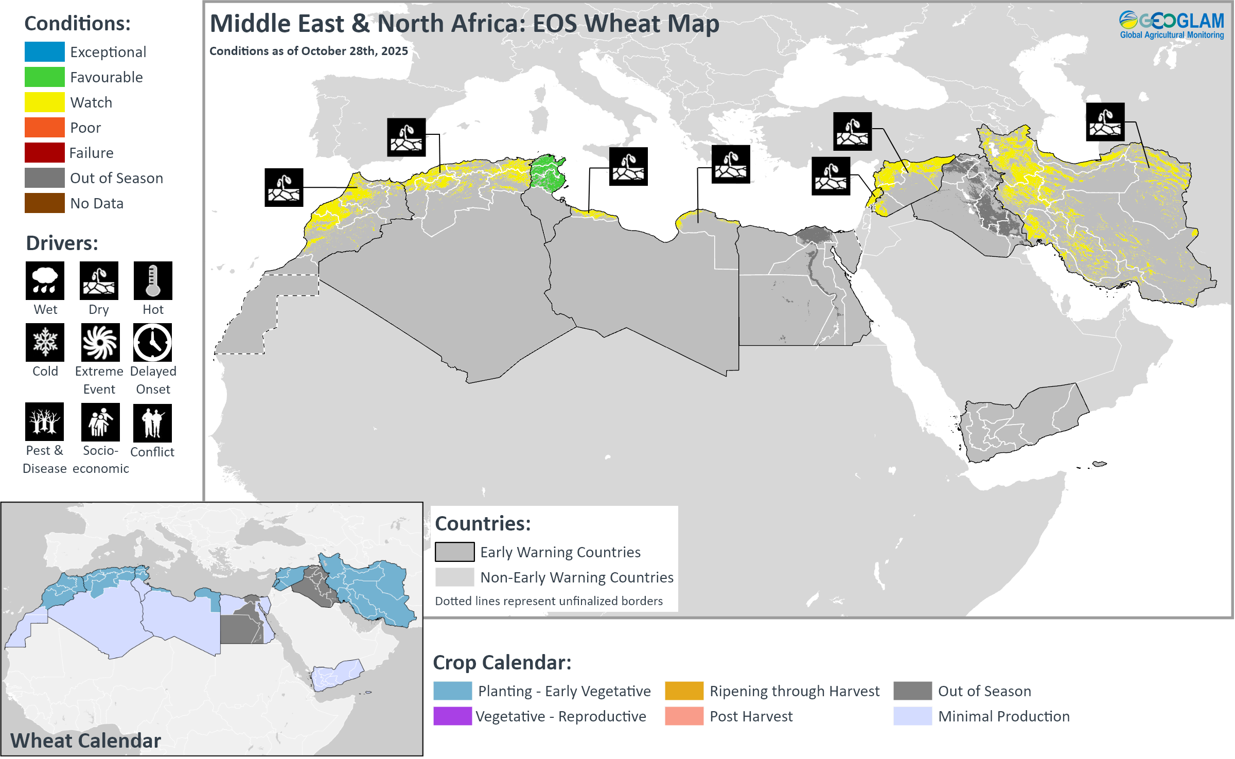
Crop condition map synthesizing wheat conditions as of October 28th. Crop conditions over the main growing areas are based on a combination of inputs including remotely sensed data, ground observations, field reports, national, and regional experts. Crops that are in other than favourable conditions are labeled on the map with their driver.
Across the Middle East and North Africa, land preparation and planting of the 2025/26 wheat crop is just beginning across Morocco, Algeria, Tunisia, Libya, Egypt, Lebanon, Syria, Iraq, and Iran under mixed conditions. Early-season dryness is impacting planting progress in Morocco, Algeria, Libya, Lebanon, Syria, and Iran, while agro-climatic conditions are favourable for ongoing planting in Tunisia. Below-average rains are expected to continue through November in many areas, which may result in below-average soil moisture conditions for planting. However, there may be some rainfall improvement from December to January, according to the Copernicus C3S multimodal seasonal forecast.
In Morocco, sowing of winter cereals will mostly start in November. The northern half of the country experienced a rainfall deficit through mid-October, particularly in Tanger-Tetouan, Gharb, Taza, Rabat, and Chaouia. In Algeria, sowing of winter cereals is underway and will conclude by January 2026. Rainfall conditions were mixed in October, with below-average amounts in the west, average amounts in the central-south, and near-average amounts in the east. In Tunisia, sowing of winter cereals is just beginning and is expected to conclude by December. Rainfall conditions have been near average in October, benefitting planting activities. In Egypt, harvesting of summer-planted maize and rice crops is complete or nearing completion, while Nili season (Nile flood) rice crops are in the vegetative to reproductive stage, and overall conditions are favourable. However, a significant and prolonged increase in Nile River water levels has led to extensive flooding in low-lying areas. The increase is expected to persist until the end of October, and the government issued a warning to the 15 most vulnerable governorates. Menoufia Governorate is the most impacted, and approximately 1,084 feddans (acres) (450 hectares) of land are at risk of inundation across Ashmoun, Menouf, El Sadat, and El Shohada regions.
In Lebanon, wheat and barley sowings are mostly expected to begin with the onset of the rainy season in November. In Syria, winter barley sowing began in October with the arrival of the first rains, while wheat sowings are expected to commence in November, and both will finalize in December. Additionally, Syria is now being considered a protracted conflict country, as the current insecurity has been ongoing for over a decade, and related production impacts are assumed to be chronic. As such, yield expectations will be compared to the five-year average rather than the pre-conflict average for monitoring purposes. In Iraq, sowing of winter barley began in October with the first rainfall, while sowing of winter wheat will take place in November and December. Additionally, rice planting between June and July was constrained by dry conditions and water shortages. The harvest, which normally takes place in September and October, is expected to be poor this year due to the ban on rice cultivation in the main rice-producing areas of Najaf and Qadissiya. Rice production in these areas was banned in May 2025 in an effort to conserve water for essential uses, such as drinking water and crops with low water requirements. In Iran, sowing of winter wheat and barley is underway with slightly drier than normal conditions in the north. Elsewhere, the rains have yet to commence. Additionally, rice harvesting finalized in October with slightly below-average output in the north, likely due to below-average winter and spring rainfall. However, overall rice production is expected to be near average.
Southern Africa
Crop condition map synthesizing wheat conditions as of October 28th. Crop conditions over the main growing areas are based on a combination of inputs including remotely sensed data, ground observations, field reports, national, and regional experts. Crops that are in other than favourable conditions are labeled on the map with their driver.
Across Southern Africa, land preparation for the 2025/26 main summer cropping season is underway, and planting has begun across Angola, Zambia, South Africa, Lesotho, and eSwatini. Start of season conditions are favourable, and seasonal rains will likely become established during November. Seasonal rainfall is expected to be generally favourable with higher chances of above normal rainfall in central and southern areas (See Regional Outlook Pg. 11). In addition, associated with the weak La Niña, there is an increased probability for above-average maize yields in Zimbabwe and South Africa. During past years with similar La Niña patterns, research indicates overall yields for Southern Africa were 5.5 percent above normal.
In Malawi, the government declared a state of catastrophe in several central and southern food-insecure districts, relating to consequences of the 2023/24 drought, rising commodity prices, and other macroeconomic drivers. The current response includes the facilitation and distribution of aid in combination with strengthening agricultural support and resources, with a focus on expanding irrigation initiatives. In Mozambique, there is an increased likelihood of average to above-average rainfall amounts through early 2026, associated with the expected La Niña event. The rains are expected to positively benefit cereal production, but there is also a higher chance of cyclone activity. Additionally, the current ongoing conflict in the north is entering its eighth year and appears to be intensifying, leading to rapidly growing displacement. In South Africa, rainfall received in some areas has contributed to good soil moisture, benefitting planting conditions.
In the Democratic Republic of the Congo, harvesting of main season cereals is underway in the north and west, while planting and development continue elsewhere. The seasonal rains began on time in September, except in areas of the far west where there are dry concerns. Additionally, ongoing conflict continues to disrupt agricultural production in the west, particularly in Muanda, and in the east, particularly in Ituri and Kivu provinces. However, recent reports indicate an improved situation in the west, and some additional households will be able to participate in the current agricultural season. Rainfall through December is expected to be mostly average, with below-average amounts possible in the southeast, northeast, and parts of the south-centre. However, low rainfall is not typically a concern for agricultural production as the country usually receives abundant precipitation.
Wheat harvesting is underway across Zambia, Zimbabwe, South Africa, and Lesotho and will finalize in November and December. In Zambia, there was a reduced planted area for wheat this season, though current yield prospects are favourable. In Zimbabwe, the wheat harvest is expected at record levels of 578,000 tonnes, surpassing both the previous year’s level and the country’s annual consumption needs and marking full wheat self-sufficiency. The record output is driven by an increase in planted area, expanded irrigation, government input support, and mechanization programs. Yield prospects remain generally favourable, except in southwestern South Africa, where dry conditions over the winter rainfall region since August have had a negative impact on dryland production. Conversely, conditions remain favourable over the summer rainfall region, where there is above-normal soil moisture and reservoirs are full, supporting irrigated crops. Well above-average yields are expected in Free State and North West provinces.
Regional Outlook: Above-average rains forecast through November with increased chances for above-average rainfall through February across parts of the central and south
In most areas, seasonal rains will likely become established during November. Following mainly average to below-average rainfall during September 26th to October 25th (Figure 1, left), many areas are forecast to receive either above-average or average rainfall during upcoming weeks, based on the 15-day CHIRPS-GEFS (Figure 1, left-middle) and 30-day SubC multi-model forecasts. These include areas in Zimbabwe, Mozambique, central-eastern South Africa, western and central Madagascar and Angola where recent rainfall deficits were observed. Above-average rainfall during the next couple of weeks may benefit land preparation and planting activities.
There are indications that seasonal rainfall conditions will likely be favorable for crop development. Seasonal forecasts across WMO (Figure 1, middle-right), NMME, and C3S ensembles do not support a confident rainfall outlook for December 2025 to February 2026 (DJF). However, these generally indicate higher chances of above-normal DJF rains in some central and southern areas (e.g. Zimbabwe and South Africa). Also related to the current weak La Niña conditions, there is an increased probability for average to above average maize yields Zimbabwe and South Africa for the 2025–2026 season, based on an Extended Outlook analysis of historical yield data. The NASA forecast for January 2026 root zone soil moisture is similarly optimistic, indicating there are greater-than 50 percent chances of above-normal January 2026 soil moisture in central-southern Zambia, central-southern Malawi, Mozambique, Zimbabwe, Botswana, central-southern Madagascar, South Africa, eSwatini, and Lesotho (Figure 1, right). Conversely, forecast elevated chances of below-normal DJF rainfall in central-northern Angola and southern DRC could result in lower than usual soil moisture levels in those areas.
Figure 1. Recent rainfall anomaly, a 15-day rainfall anomaly forecast, a 3-month rainfall forecast, and a NASA soil moisture forecast for January 2026. Left: Difference from average precipitation for September 26th to October 25th, 2025, using CHIRPS3 for September and CHIRPS3 preliminary data for October. From the CHC Early Estimates. Left-middle: CHIRPS-GEFS precipitation anomaly forecast for October 29th to November 12th, 2025. The NCEP GEFS forecast from 10/29 is bias-corrected using CHIRPS3 data. Middle-right: WMO probabilistic forecasts for December 2025 to February 2026 precipitation terciles, based on models initialized in October. From the WMO Lead Centre Long-Range Forecast Multi-Model Ensemble. Right: Probabilistic forecast for January 2026 root zone soil moisture tercile, from the NASA Hydrological Forecast and Analysis System’s FLDAS forecast. The FLDAS forecast uses CHIRPS and MERRA-2 reanalysis data through September 2025 and forecasted meteorological conditions for October 2025 to January 2026 from the North American Multi-Model Ensemble (NMME) and the GEOSv2 model.
Source: UCSB Climate Hazards Center
Central & South Asia
Crop condition map synthesizing wheat conditions as of October 28th. Crop conditions over the main growing areas are based on a combination of inputs including remotely sensed data, ground observations, field reports, national, and regional experts. Crops that are in other than favourable conditions are labeled on the map with their driver.
In Central & South Asia, spring wheat harvesting finalized in October under favourable conditions, including in northern Kazakhstan, where there has been a noticeable improvement following persistent rains in September that delayed harvesting work and led to grain shedding. Adequate rains during September and October across the subregion provided good soil moisture, and yields are expected to be favourable.
Land preparation and planting of winter wheat is just beginning in southern Kazakhstan, Kyrgyzstan, Tajikistan, Uzbekistan, Turkmenistan, Afghanistan, and Pakistan, and start of season conditions are favourable. However, drier than normal conditions are expected through January 2026 across most areas, aligning with typical La Niña related dryness, and could extend through April. The dry conditions could reduce winter wheat planted area, increasing dependence on the spring season (See Seasonal Forecast Alert Pg. 13). Furthermore, despite ongoing bans on poppy cultivation in Afghanistan and Pakistan, there was a notable expansion in poppy growing areas in 2025, particularly in Afghanistan’s Badakhshan and Helmand provinces and Pakistan’s Balochistan province and surrounding areas. The increases indicate a shift away from wheat and other crops as farmers turn to the more lucrative poppy crop.
In Afghanistan, harvesting of rainfed wheat finalized in September, with below-average prospects in rainfed areas of the north, northeast, and some central areas. Conversely, harvesting of irrigated wheat continued in some Central Highlands and higher elevations of the northeast through early October, and prospects for irrigated crops are generally favourable due to the use of groundwater to supplement water deficits this season. Harvesting of second season maize and rice crops is underway and is expected to finalize in November. The second season crops are mostly irrigated, and there was prior concern due to ongoing drought conditions and limited irrigation water availability. However, the primary impact of limited water availability for this season was a reduced planted area, and impacts to growing conditions were mostly localized in the east and northeast. Current conditions for standing crops are favourable with a near-normal harvest expected. Additionally, land preparation is underway for the 2025/26 wheat season, and planting will continue through December with timing contingent on precipitation and temperature outcomes. However, drier than normal conditions have hindered progress, particularly in rainfed areas, and farmers are waiting for rain to begin planting. Snow water equivalent levels are showing record low values, and precipitation is expected to be lower than normal through January 2026, which could worsen drought conditions and further deplete surface and groundwater resources (See Seasonal Forecast Alert Pg. 13). During past years with similar La Niña patterns, winter wheat yields were 4 percent below normal, and spring wheat yields were 10 percent below normal on average. However, forecast precipitation improvement from January onwards suggests a greater likelihood for comparatively better yield and production outcomes for irrigated wheat compared to rainfed wheat. Furthermore, a 6.3 magnitude earthquake impacted northern Afghanistan on November 2 and was the second major earthquake in two months, resulting in infrastructure damage and impacts to agricultural and livestock livelihoods in rural areas of Kunar and Nangarhar located in the east. Some agricultural structures, including tunnels and irrigation systems, were also impacted, and damage assessments are underway. In Pakistan, harvesting of Kharif (summer) season rice and maize is underway. The planted area under rice has been expanding in recent years and increased by 7.2 percent in 2025, according to a recent economic survey. Overall production of rice and maize declined from the previous year but is still expected to be near to above average. A strong and prolonged 2025 monsoon season resulted in flooding from late June through September across many areas. The floods inundated farmland and damaged rice fields across Punjab province, the country’s breadbasket and a key producer of Basmati rice varieties, and stagnant floodwater remained in some areas as of mid-October. The full extent of the damage is uncertain and will depend on how quickly fields recover and the quality of the remaining produce. Elsewhere, prospects for Kharif season crops are generally favourable despite flooding impacts in some areas. Additionally, wheat planting is just beginning under favourable conditions, and while some areas of Punjab remain inundated by waterlogging and delayed drainage following the monsoon flooding, the impacts are localized. Parts of Sindh Province were also affected by flooding, which could adversely impact water management and wheat irrigation; however, planting conditions remain generally favourable. Additionally, the emerging La Niña event is expected to result in drier than normal weather in the northern rainfed Barani areas through January 2026, which may impact planting progress (See Seasonal Forecast Alert Pg. 13).
Seasonal Forecast Alert: Observed drier-than-average conditions are forecast to continue through January across most areas of Central Asia
Below-normal precipitation is anticipated in Southern and Central Asia from late 2025 to early 2026, based on model precipitation forecasts and ongoing La Niña conditions.
Following observed drier-than-average conditions through late October, below-average precipitation is forecast during November, according to CHIRPS-GEFS next 15-day (Figure 1-left), ECMWF weekly, and SubC next 30-day forecasts.
Consistent with the observed tendency for drier-than-normal conditions during many La Niña events, models forecast that November 2025 to January 2026 (NDJ) precipitation will likely be below normal in Afghanistan, Turkmenistan, Tajikistan, southern and central Uzbekistan, eastern Kyrgyzstan, and southern Kazakhstan. Across southern and central-southern Asia, chances of below-normal NDJ precipitation totals range from 40 to 70 percent, with less confidence after December, according to the WMO (Figure 1 middle-left), C3S, and NMME ensemble forecasts.
At present there is a high level of uncertainty about precipitation conditions during late winter to early spring. However, there is potential for prolonged dry conditions, according to some models used in the long-range February to April 2026 precipitation forecasts in WMO (Figure 1 middle-right) and NMME ensembles. Forecasts in coming months will be monitored. Recent La Niñas have negatively impacted winter wheat and spring crops in the region.
A dry fall could lead to a reduction in area planted with winter wheat— and a greater reliance on the spring season to meet food and income needs. Prolonged dry conditions would negatively impact livelihoods dependent on rangeland and surface water resources. Recurring seasons with below-average precipitation have led to a long sequence of 6 years in a row with below-average regional snow water equivalent (SWE) amounts, for areas in and near Afghanistan. Last year, the snow season ended with the lowest SWE values of the past 25 years. The extreme dry conditions have resulted in a new low SWE level to begin the current 2025–2026 season (Figure 1-right). If winter precipitation is impacted and poor snow conditions occur, hydrologic and agricultural drought conditions would continue in Afghanistan. The impacts would constrain rainfed agriculture as well as snow-fed water resources that are used in irrigated agriculture later in the year. Increases in groundwater extraction and decreases in water levels would also be expected.
Figure 1. Season rainfall anomaly outlook, 3-month rainfall forecasts, and the regional snow water equivalent. Left: Difference from average precipitation for October 1st to November 10th, 2025, using CHIRPS3 preliminary data for October and a 15-day CHIRPS3-GEFS forecast for October 26th to November 10th. From the CHC Early Estimates. Left-middle & Right-middle: WMO probabilistic forecasts for (Left) November 2025 to January 2026 and (Right) February to April 2026 precipitation terciles, based on models initialized in October. From the WMO Lead Centre Long-Range Forecast Multi-Model Ensemble. Note: The longer-range FMA 2026 forecast is based on fewer models than for NDJ 2025-2026, and future FMA forecasts are subject to change. Right: Variations in regional Snow Water Equivalent (SWE) (mm) for a region surrounding Afghanistan. The dotted line indicates average SWE (2001-2024 period), the blue line shows SWE for Oct. 2024 - Sep. 2025, and the red line shows SWE for Oct. 1st to 30th, 2025. From NASA, using SWE estimates from the FLDAS Central Asia model.
Source: UCSB Climate Hazards Center
Southeast Asia
Crop condition map synthesizing rice conditions as of October 28th. Crop conditions over the main growing areas are based on a combination of inputs including remotely sensed data, ground observations, field reports, national, and regional experts. Crops that are in other than favourable conditions are labeled on the map with their driver.
Crop Coverage Update: From November 2025, Maize conditions will be reported for Southeast Asia with support from the ASEAN Food Security Information System (AFSIS).
In southern Southeast Asia, dry-season rice is in the harvesting stage under favourable conditions due to sufficient irrigation during the growing season. Dry-season maize is also in the harvesting stage, and yields are expected to be favourable due to adequate irrigation water and sunlight. Additionally, planting of wet-season rice is underway and is progressing faster than last year due to adequate irrigation water supply. Seeding of wet-season maize has begun with sufficient irrigation water.
In northern Southeast Asia, wet-season rice is in the grain filling to harvesting stage under generally favourable conditions due to conducive weather during the growing season. Additionally, wet-season maize is in the reproductive to harvesting stage. Despite storm damage this season, overall growing conditions are generally favourable, except in northern Viet Nam. In September and October, some areas experienced significant flooding caused by several tropical storms. From September 25–27, Tropical Cyclone Bualoi (locally named Opong) crossed the eastern and central Philippines, affecting Eastern Samar, Masbate, and Western Visayas, before entering the South China Sea. On September 28 to 29, Bualoi made landfall in central-northern Viet Nam, including in Ha Tinh and Nghe An provinces, as a strong tropical cyclone, bringing extreme rainfall, flooding, and landslides. By September 30, Bualoi weakened as it moved inland over Laos and dissipated over eastern Myanmar. Additionally, in early October, Tropical Cyclone Matmo impacted areas of the northern Philippines and northern Viet Nam. The extent of damage to total rice production is expected to be limited, except in northern Viet Nam where damage assessments are underway. Additionally, overall conditions are favourable for maize development, but production could reduce slightly.
Elsewhere in Southeast Asia, including Sri Lanka, Nepal, Bangladesh, and the Democratic People’s Republic of Korea, conditions remain generally favourable, except in southeastern Nepal where there was an unexpected drought.
In Indonesia, October is the fourth month of both dry-season rice and dry-season maize harvesting. For dry-season rice, the total harvested area is 4.0 million hectares with favourable yields expected, and despite moderate to high rainfall received in October, no damage has been reported. For dry-season maize, the total harvested area is 0.9 million hectares, and yield is expected to be favourable due to sufficient irrigation water and sunlight. Planting of wet-season rice is underway with a current area of 0.4 million hectares and faster progress than last year. Crops are in the vegetative stage under favourable conditions with good rainfall received in early October. Planting of wet-season maize has also started, with a current seeded area of 0.2 million hectares, and growing conditions are favourable due to sufficient irrigation water. In Malaysia, harvesting of dry-season rice is now complete and has reached 245 thousand hectares. Growing conditions were favourable this season, and production is expected to be similar to last year. Additionally, around 88 percent of dry-season maize has been harvested as of October with favourable yields. Planting of wet-season rice has reached approximately 38 thousand hectares, representing 12 percent of the target area. Crops are mostly in the young panicle forming to grain filling stage, predominantly in central areas of the country, and both weather conditions and irrigation water supply have been conducive for paddy cultivation. Replanting of wet-season maize continues in completed areas, and growing conditions are favourable due to stable weather outcomes, though slightly drier than normal conditions have slowed growth in some late-planted fields. In Brunei, harvesting of dry-season rice is mostly complete with a favourable yield of 3.51 metric tons per hectare. While there were concerns this season regarding limited precipitation throughout the planting season, solar radiation and temperatures remained conducive for crop development. Additionally, despite high rainfall received towards the end of the harvesting stage, weather conditions for most of the harvest were adequate. For wet-season rice, about 10 percent of the targeted area is in the transplanting stage for both irrigated and rainfed areas, and growing conditions remain favourable.
In the Philippines, wet-season rice planted from July to August is currently in the heading to flowering stage. Additionally, wet-season maize planted from May to June is in the grain filling to harvesting stage. From September to the first week of October, the combined effects of the southwest monsoon and five tropical cyclones damaged 94.2 thousand hectares of the rice area, with an estimated volume loss of 216.6 thousand metric tons, and damaged 19.3 thousand hectares of maize, with an estimated volume loss of 37.2 thousand metric tons. Additionally, on September 30, a 6.9 magnitude earthquake struck the Central Visayas region, resulting in infrastructure damage and displacements. Another earthquake impacted Luzon on October 9, and a 7.4 magnitude earthquake impacted Mindanao region located in the south on October 10, with an epicentre in Davao Oriental. This was the third earthquake to hit the country in 10 days and was followed by another 6.8 magnitude earthquake on the same day in the same coastal area. Despite the impacts of severe storm events and several consecutive earthquakes, overall rice conditions remain favourable as rice-growing areas were not severely impacted and likely experienced conducive above-normal rainfall. For maize, yield is expected to be near average but may decrease by 2.6 percent compared to last year’s record of 3.1 metric tons. In Thailand, wet-season rice is in the grain filling stage, and wet-season maize is in the harvesting stage. Planted area for maize increased this season due to a decline in competitive crop prices, and some farmers have shifted from cassava to maize cultivation due to the risk of Cassava Mosaic Disease (CMD). During September and October, the country experienced significant flooding caused by a strong southwest monsoon and several tropical storms, including Bualoi and Matmo. While the floods damaged an estimated 60 thousand hectares of rice, the impacts were localized, and generally adequate rainfall and sunlight resulted in favourable tillering and overall rice development. However, total rice production is expected to decline, primarily due to a reduction in the cultivated area. Maize yield is expected to increase compared to the previous season. However, the recent heavy rains resulted in a high moisture content for harvested crops, which may affect post-harvest handling and storage. In northern Viet Nam, wet-season rice is in the grain filling stage, and harvesting is underway in some provinces. The country has been impacted by an active typhoon season, including the succession of powerful storms that impacted north and central provinces in recent months, resulting in torrential rains, floods, and landslides. Tropical storms in late September damaged over 100 thousand hectares of paddy fields, and yields may be impacted. Additionally, wet-season (summer-autumn) maize is in the harvesting stage, and several mountainous provinces were affected by tropical storms and flooding during the flowering and grain-filling stages. As a result, this year’s wet-season maize production is expected to decline due to reductions in both cultivated area and yield. In the south, harvesting of wet-season (summer-autumn) rice is complete with an average yield of 6 tons per hectare, which is similar to last year. The other wet-season (autumn-winter and seasonal) rice is in the grain filling to harvesting stage, and weather conditions are expected to remain favourable for rice growth. Wet-season (summer-autumn) maize is also in the harvesting stage in the south, and yields are expected to increase compared to last year due to stable weather conditions throughout the growing period. In lowland areas of Laos, wet-season rice is in the grain filling to early harvesting stage with a final planted area of 756 thousand hectares. Earlier planted rice has been harvested, representing 10 percent of the planted area, and yields are expected to slightly decrease due to the passage of multiple tropical cyclones in July and August, which resulted in flooding, landslides, and localized crop losses, particularly in Sayaboury, Laung Prabang, Houaphanh, Xiengkhouang, and Vientiane provinces. In upland areas, the final planted area of wet-season rice is 75 thousand hectares, and crops are now in the grain filling to early harvesting stage. Some areas in the north and central regions have been affected by landslides and pest outbreaks in October, but overall conditions remain favourable. Additionally, the final planted area for wet-season maize is estimated at 95 thousand hectares, accounting for 90 percent of the national production plan, with the shortfall attributed to the passage of multiple tropical cyclones during the season. Crops are in the late reproductive to early harvesting stage, and the yield is forecast to decline slightly to around 4.94 tons per hectare. Wet-season maize production is expected to be 519 thousand tons, which is below the national target plan. In Myanmar, planting of wet-season rice is now complete, with 5.95 million hectares accounting for 98.5 percent of the national plan. Most crops are in the grain filling stage under favourable growing conditions, and while monsoon floods impacted several areas, the impact on rice yields is limited. In October, harvesting of earlier planted crops began, and about 60 thousand hectares of wet-season rice have been harvested with a favourable yield of 4.4 tons per hectare, which is slightly higher than last year. Additionally, harvesting of wet-season maize is complete and over 100 percent of the national plan, and 26 percent of the cultivated area has been harvested. Despite below-normal rainfall received in October, soil moisture conditions remain adequate. Crops are mostly in the reproductive stage, and growing conditions are good with favourable yields expected. In Cambodia, harvesting of wet-season rice reached 863 thousand hectares out of a planted area of 3.2 million hectares. Yields are generally favourable, and total production is expected to be 3.4 million tons and 8.1 percent higher than last year. Planting of wet-season maize finalized with 206 thousand hectares, and 68 percent of the cultivated area has been harvested. Yield is estimated to be 6 tons per hectare, with abundant sunlight contributing to a favourable harvest. Additionally, irrigation of dry-season rice may start late as the water level in the Mekong lowland area is higher than normal. Seeding of dry-season maize will start next month.
In Sri Lanka, harvesting of Yala season maize (10 percent of annual maize output) and Yala season rice (35 to 40 percent of annual rice output) finalized in October under favourable conditions. Planting of Maha season maize (90 percent of annual maize output) and Maha season rice (60 percent of annual rice output) is just beginning under favourable conditions. In Nepal, main season rice crops are in the vegetative to reproductive stage for harvest from November, and conditions are mostly favourable except in Madhesh Province located in the southeast, which experienced an unexpected drought. Wheat planting is just beginning under favourable conditions. In Bangladesh, Aman season rice (35 percent of annual rice output) and main season sorghum are in the vegetative to reproductive stage under favourable conditions. In the Democratic People’s Republic of Korea, rice harvesting finalized in October under favourable conditions.
For detailed description of the pie chart please see description box on the bottom of the page.
Central America & Caribbean
Crop condition map synthesizing Maize 2 (Segunda season) conditions as of October 28th. Crop conditions over the main growing areas are based on a combination of inputs including remotely sensed data, ground observations, field reports, national, and regional experts. Conditions that are other than favourable are labeled on the map with their driver.
In Central America, harvesting of Primera season cereals finalized in September with mixed production prospects due to a combination of late and erratic rains, hot temperatures, and lack of adequate irrigation water availability. Generally poor outcomes are expected in most of Guatemala, parts of southern Honduras as well as Santa Bárbara and Cortés located in the west, and parts of western Nicaragua. Conversely, harvesting outcomes were favourable in the key producing southern region of Guatemala, El Salvador, most of northern Honduras, and eastern Nicaragua.
Additionally, Segunda/Postrera season maize and beans are in the vegetative to reproductive stage across Guatemala, El Salvador, Honduras, and Nicaragua. Erratic rains received over the last month, particularly over parts of Nicaragua and Guatemala, may signal an early end to the rainy season in Central America. However, conditions remain mostly favourable, except in Guatemala where the erratic precipitation and high temperatures have resulted in delayed plantings and crop development, and subsistence farmers have not commenced sowing activities. While growing conditions are currently favourable in Honduras, an above-normal rainy season has resulted in hampered crop development and losses in localized areas.
In Haiti, harvesting of main season rice finalized in October, and conditions have been downgraded to poor due to localized torrential rains associated with the above-normal hurricane season, which could impact crop development. Above-average rainfall in October was followed by the passage of Tropical Storm Melissa in late October, which brought heavy rain, strong winds, and flooding to parts of the country, particularly in the south, and farmers are waiting for access to their crop fields to determine the impact of the hurricane. So far, damage has occurred to banana plantations, fruit trees, other crops, and livestock, and land preparation for the winter season has been interrupted and delayed. Furthermore, prolonged violence and instability continue to limit access to cropping lands and agricultural outcomes, and displacement levels have reached the highest figure ever recorded as of October, representing a 36 percent increase since late 2024. In Cuba, rice and maize harvesting is underway with favourable outcomes expected, except in the east which was impacted by recent hurricanes. Between September 27 and October 3, Hurricane Imelda brought flooding and landslides to eastern Cuba. Additionally, Hurricane Melissa made landfall on October 29 in the eastern provinces of Granma, Santiago de Cuba, Guantanamo, Holguin, and Las Tunas, ranking among the strongest Atlantic storms on record and generating torrential rains, flooding, and landslides. As of early November, 78,700 hectares of crops have been damaged and 28,000 heads of livestock have been lost in Granma province. Total damages to crops and infrastructure are still to be assessed.
Pie Chart Description: Each slice represents a country’s share of total regional production. The proportion within each national slice is colored according to the crop conditions within a specific growing area; grey indicates that the respective area is out of season. Sections within each slide are weighted by the sub-national production statistics (5-year average) of the respective country. The section within each national slice also accounts for multiple cropping seasons (i.e. spring and winter wheat) and are a result of combining totals from multiple seasons to represent the total yearly national production. When conditions are other than favourable icons are added that provide information on the key climatic drivers affecting conditions.
Information on crop conditions in the main production and export countries can be found in the Crop Monitor for AMIS, published November 6th, 2025.
Sources and Disclaimers: The Crop Monitor assessment is conducted by GEOGLAM with inputs from the following partners FEWS NET, JRC, WFP, ARC, AFSIS, MESA, ICPAC, FAO GIEWS, Applied Geosolutions and UMD. The findings and conclusions in this joint multi-agency report are consensual statements from the GEOGLAM experts, and do not necessarily reflect those of the individual agencies represented by these experts.