
Crop Monitor for Early Warning
Report Information
No. 118: Published August 6th 2026
Conditions as of July 28th
For access to all reports, please visit the Archive.
Please visit the Referencing Guidelines page for information on how to cite the Crop Monitor reports and products.
Overview
In East Africa, persistent deficits this season are expected to result in failed yield outcomes in southern Somalia and poor outcomes in Ethiopia (Belg season), Burundi, Rwanda, northeastern Uganda, and Kenya.
In West Africa, overall conditions remain favourable for main season cropping activities, except in conflict-affected areas.
In the Middle East & North Africa, winter wheat harvesting finalized under favourable conditions following rainfall improvements from December 2025, except in northwestern Libya and southern Iraq.
In Southern Africa, El Niño-induced dry spells could negatively impact the start of the 2026/27 season in September. Conditions remain favourable for winter wheat development.
In Central & South Asia, overall conditions remain favourable for winter wheat harvesting and spring wheat development despite recent drought and heat waves in Kazakhstan.
In Southeast Asia, conditions remain mostly favourable for rice and maize crops, except in Cambodia, Thailand, and southern Viet Nam where yields may be impacted by dry and hot weather outcomes.
In Central America & the Caribbean, concern remains for Primera season maize and bean crops due to erratic and insufficient rains since the start of the season.
Crop Conditions at a Glance
Crop condition map synthesizing information for all Crop Monitor for Early Warning crops as of July 28th. Crop conditions over the main growing areas are based on a combination of inputs including remotely sensed data, ground observations, field reports, national, and regional experts. Regions that are in other than favourable conditions are labeled on the map with a symbol representing the crop(s) affected.
EAST AFRICA: Harvesting of Belg season maize finalized in Ethiopia under poor conditions, while planting and development of main/Meher season cereals continue across the north. Along the south, failure outcomes are expected for main season crops in southern Somalia, and poor outcomes are expected across Burundi, Rwanda, northeastern Uganda, and Kenya. Elsewhere, there is concern in most areas due to delayed rains and severe deficits this season, which are expected to continue through September (See Regional Alert Pg. 8).
WEST AFRICA: Harvesting of main season cereals is underway along the Gulf of Guinea while planting and development continues along the Sahel, and agro-climatic conditions remain favourable despite overly dry conditions in some northern areas and overly wet conditions in some southern areas. Fuel and fertilizer price increases could lead to reduced yields for the upcoming 2026/27 season.
MIDDLE EAST & NORTH AFRICA: Winter wheat harvesting finalized in July under generally favourable conditions as a dry start to the season was followed by rainfall improvements that benefitted yields in most areas, except in northwestern Libya and southern Iraq.
SOUTHERN AFRICA: Most areas are now out of season, and planting for the 2026/27 main season will begin in September, with El Niño-induced dry spells forecast across some areas. Winter wheat continues to develop under favourable conditions.
CENTRAL & SOUTH ASIA: Harvesting of winter wheat is nearing completion while spring wheat continues to develop, and overall conditions remain favourable. While dry and hot conditions impacted most regions of Kazakhstan this summer, recent rains in the north and irrigation use in the south are supporting wheat cropping activities.
SOUTHEAST ASIA: Conditions remain favourable for both rice and maize crops in the south, while a mix of drought impacts and hot conditions are impacting wet-season rice in Cambodia, Thailand, and southern Viet Nam, and higher input costs are impacting both wet-season rice and wet-season maize production in Thailand. El Niño-induced dry conditions are expected to coincide with the peak of the dry season in Indonesia (See Regional Outlook Pg. 17). Recent torrential monsoon rains are affecting eastern Bangladesh.
CENTRAL AMERICA & CARIBBEAN: Harvesting of Primera season maize and bean crops is just beginning, and erratic and insufficient rains as well as high temperatures since the beginning of the season continue to negatively affect crop growth despite increased rains received in June.
Global Climate Outlook: Two-week forecast of areas of above or below-average precipitation
The two-week forecast (Figure 1) shows a chance of above-average precipitation over the western US, central and southeastern Brazil, eastern Bolivia, eastern Paraguay, northern Chile, southern Argentina, southeastern Madagascar, northcentral Mongolia, the eastern Russian Federation, southwestern and southern China, and southeastern Australia.
There is also a risk of below-average precipitation over central and western Canada, the Midwest and southern US, Mexico, Guatemala, El Salvador, Honduras, western Nicaragua, western Cuba, Haiti, the Dominican Republic, western Colombia, eastern Venezuela, Guyana, Suriname, French Guiana, northern and northeastern Brazil, southeastern Argentina, southern Chile, Ireland, the western United Kingdom, northern Spain, France, Belgium, Germany, southern Poland, Czechia, Slovakia, Hungary, Ukraine, Romania, Serbia, Croatia, central Italy, Bosnia and Herzegovina, Montenegro, Kosovo, Albania, Greece, the southern and eastern Russian Federation, western Mauritania, Senegal, eastern Mali, southern Sierra Leone, Liberia, southern Côte d'Ivoire, Burkina Faso, Ghana, Togo, Benin, central Niger, southwestern Nigeria, central Chad, central Sudan, southeastern South Sudan, Eritrea, southwestern and northeastern Ethiopia, western Kenya, Uganda, Rwanda, Burundi, northern Tanzania, the central and southern Democratic Republic of the Congo, the central Republic of the Congo, southern Gabon, northern Angola, northeastern Mozambique, Yemen, Oman, Kazakhstan, northern Uzbekistan, western Kyrgyzstan, central eastern Afghanistan, Pakistan, western and southern India, Sri Lanka, central and northwestern China, the Republic of Korea, southern Myanmar, central Cambodia, the southern Philippines, Malaysia, Brunei, Indonesia, Papua New Guinea, and northeastern and southwestern Australia.
Figure 1: IRI SubX Precipitation Biweekly Probability Forecast for 8 – 21 August 2026, issued on 31 July 2026. The forecast is based on statistically calibrated tercile category forecasts from three SubX models. Source: IRI Subseasonal Forecasts Maproom
Climate Influences: El Niño Present and forecast to develop into a strong event by September to November
El Niño conditions are present. This will most likely be a very strong event (81% chance for October to December 2026, according to the July 2026 NOAA ENSO outlook), ranking as one of the strongest since 1950. El Niño conditions are forecast through April 2027 (97% chance).
El Niño events tend to enhance rainfall in Central Asia, southern North America, south-eastern South America, southern Europe, eastern and southern East Africa, and southern and eastern China. Drier-than-average conditions tend to occur in Central America, the Caribbean, northern South America, parts of western and northern East Africa, the Sahel region, Southern Africa, India, Northern China, the Maritime Continent, and Australia. Thus far in the 2026 El Niño, severe rainfall deficits have developed in East Africa, Central America, India, and Southeast Asia.
Positive Indian Ocean Dipole (IOD) conditions are forecast during September to December 2026, with a strong event possible. Positive weekly IOD values from the Bureau of Meteorology indicate the event is developing. A positive IOD tends to enhance the drying influence of El Niño in Australia and the Maritime Continent and substantially increase the chances of a wet and intense East Africa short rains season.
During late July through early August 2026, abnormally hot temperatures are forecast in agricultural areas of the western, central and southeastern United States, Mexico, Central America, the Caribbean, northern Colombia, central Brazil, southern and central Europe, the Sahel region, East Africa, Yemen, southern and northern India, Pakistan, central Asia, northeastern China, the Korean Peninsula, southern Japan, central Myanmar, central Indonesia, and the northern Philippines (Figure 1). Earlier in July, areas in Europe, northern, central, and eastern Africa, the Middle East, central, southern, southeast Asia, central-eastern China, the western, central, and eastern United States, Central America, and northern South America were impacted by heat.
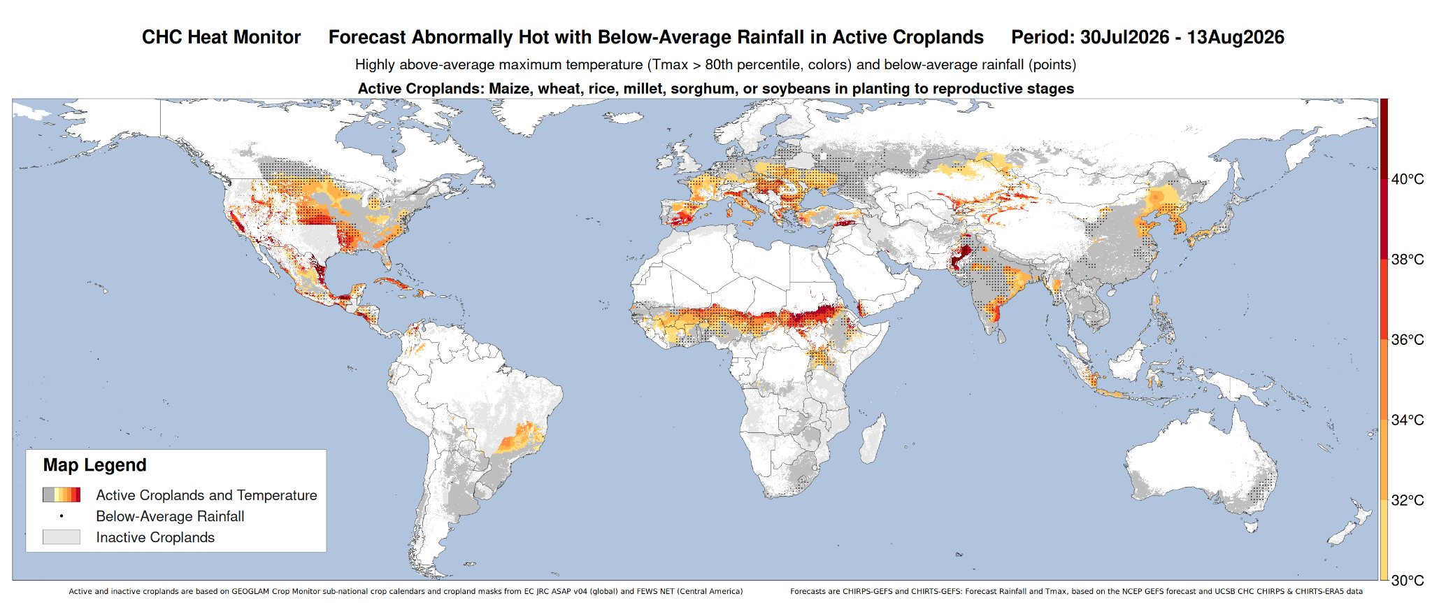
Figure 1: CHC AgriHeat Forecast for July 30 to August 13, 2026. Forecast 15-day average maximum temperatures are shown where these will be abnormally hot (Tmax > 80th percentile and > 30 °C) and in active crop growing areas. Areas with forecasted below-average rainfall for this period are also identified. Based on the 15-day CHIRTS-GEFS and CHIRPS-GEFS forecasts from July 30, 2026. Source UCSB Climate Hazards Center.
East Africa
Crop condition map synthesizing Maize 1 crop conditions as of July 28th. Crop conditions over the main growing areas are based on a combination of inputs including remotely sensed data, ground observations, field reports, national, and regional experts. Conditions that are other than favourable are labeled on the map with their driver.
Across northern East Africa, harvesting of Belg season maize finalized in Ethiopia under poor conditions due to generally dry weather outcomes received this season and movement restrictions in northern areas. Conversely, comparatively better rainfall outcomes are expected to result in favourable yields in the Former SNNPR region located in the southwest. Harvesting of first season maize and sorghum is just beginning in bimodal regions of southern South Sudan, while planting and development of main season crops continues in Sudan, unimodal regions of South Sudan, Ethiopia (Meher season), Eritrea, and Yemen. Delayed and below-average rains are negatively impacting cropping prospects in most areas, and ongoing conflict continues to disrupt agricultural production in Sudan. Over the past 90 days, severe rainfall deficits have affected several parts of East Africa, and drought conditions are present across southern South Sudan and parts of east and central Ethiopia.
Across southern East Africa, harvesting of Season B maize and sorghum finalized in Burundi and Rwanda, while harvesting of main season cereals is nearing completion in bimodal regions of Uganda, bimodal regions in the eastern half of Kenya, Somalia, and bimodal regions of north and northeastern United Republic of Tanzania. Elsewhere, crops continue to develop across unimodal regions in northern Uganda and unimodal regions in the western half of Kenya. This season, persistent dry and hot seasonal outcomes have significantly impacted the Gu season in Somalia, and conditions in the south have been downgraded to failure. Additionally, persistent deficits are expected to result in poor yield outcomes elsewhere in Somalia as well as in Burundi, Rwanda, Karamoja region in northeastern Uganda, and throughout most of Kenya. Elsewhere, the dry conditions present an ongoing concern for end of season outcomes, except in bimodal regions of north and northeastern United Republic of Tanzania where early rains benefitted cropping prospects.
During August, drier than normal conditions are expected over most rainfall-receiving areas. Warmer than normal conditions are also expected over most areas, particularly over eastern South Sudan and western to central Ethiopia. For the August to September period, drier than normal conditions are expected over most areas, which is likely to significantly reduce overall production prospects. Conversely, wetter than normal conditions are expected over the eastern Horn during August to September (See Regional Alert Pg. 8). Additionally, the strengthening El Niño and a forecast positive Indian Ocean Dipole are associated with a likely shift to high rainfall outcomes across most areas during October to December (See Climate Influence Pg. 4 and Regional Outlook Pg. 9).
Crop condition map synthesizing Maize 2 conditions as of July 28th. Crop conditions over the main growing areas are based on a combination of inputs including remotely sensed data, ground observations, field reports, national, and regional experts. Conditions that are other than favourable are labeled on the map with their driver.
Northern East Africa & Yemen
In Sudan, planting of main season millet and sorghum crops continues with concern due to delayed and below-average rains, which are expected to continue through the remainder of the June to September rainfall season. Additionally, some areas of the country experienced extreme heat in July, compounding drying impacts (See Regional Alert Pg. 8). Conversely, the country will likely experience a shift to high rainfall amounts from October, in accordance with the strengthening El Niño and likely positive Indian Ocean Dipole (See Climate Influences Pg. 4 and Regional Outlook Pg. 9). Additionally, ongoing conflict continues to disrupt agricultural activities throughout the country. In South Sudan, harvesting of first season cereals is just beginning in bimodal regions of Central and Western Equatoria, while crops continue to develop across unimodal regions of the country. Early and widespread rains received in March encouraged localized early planting in unimodal areas but were followed by dry spells across most of the country that negatively affected crop growth. Dry conditions are expected to continue through September (See Regional Alert Pg. 8). Additionally, while the rainfall deficits remain the primary source of cropping concerns, flooding inundation continues to affect the Sudd wetlands as of late July. Flooding has become a recurring event, following seven consecutive years of flooding from 2019 to 2025. Sustained high upstream lake levels and periods of high-intensity rainfall have resulted in floodwaters increasingly failing to recede during the dry season. In Eritrea, planting of sorghum and wheat is just beginning with concern due to delayed and below-average rains, which are expected to continue through September (See Regional Alert Pg. 8). In Ethiopia, harvesting of Belg season maize finalized under generally poor conditions, as most regions were impacted by a dry spell and below-average rainfall, except for the Former SNNRP region located in the southwest which received comparatively better rains. Additionally, movement restrictions negatively impacted cropping activities in Amhara and Tigray regions in the north. Meher season cereals are in the vegetative to reproductive stage, and extreme deficits since the start of the June to September Kiremt season are negatively impacting yield prospects. Additionally, Afar region experienced extreme heat in July (See Regional Alert Pg. 8). In Yemen, sorghum and spring wheat crops are in the vegetative to reproductive stage, and good rains at the start of the season were followed by a shift to dry conditions that are expected to continue through September (See Regional Alert Pg. 8).
Crop condition map synthesizing Sorghum 1 conditions as of July 28th. Crop conditions over the main growing areas are based on a combination of inputs including remotely sensed data, ground observations, field reports, national, and regional experts. Conditions that are other than favourable are labeled on the map with their driver.
Southern East Africa
In Somalia, harvesting of Gu season maize and sorghum is just beginning. Prolonged dry conditions for both the antecedent October to November 2025 Deyr rains as well as for the April to June 2026 Gu rains negatively impacted cropping productivity this season, and hotter-than-normal temperatures compounded rainfall deficits. Conditions have been downgraded to failure in the south with well below-average yields expected, and poor outcomes are expected along the central and northwestern producing regions. Conversely, over the past week, extreme rains received across Modadishu were beneficial for pasture, soil moisture, and surface water replenishment. A strengthening El Niño and forecast positive Indian Ocean Dipole are expected to bring a shift to wet conditions from October, which could benefit the start of Deyr planting in October but also increases the risk of flooding (See Climate Influences Pg. 4 and Regional Outlook Pg. 9). In Kenya, harvesting of long rains cereals is just beginning in the bimodal and minor producing eastern half of the country while crops continue to develop in the unimodal and major producing western half of the country, and conditions have been downgraded to poor throughout most areas due to ongoing rainfall deficits that are expected to continue through September (See Regional Alert Pg. 8). Unimodal and major producing western areas were worst affected by erratic rains and prolonged deficits since April, and while some crops started graining, most are stunted. In these key producing areas, preliminary estimates suggest a 15 percent decline in maize yields, and grain production is likely to be below average due to the moisture deficit. Conditions are slightly better along the unimodal coast compared to other areas of the country. However, rainfall received at the start of the season was followed by dry conditions in late March into April, as well as high temperatures along the coastal strip that stunted crop growth and are likely to lead to poor yield outcomes. Furthermore, conditions are comparatively better in the central region, which received an early start to the season and less intense temperatures. Production at the national level is estimated at 15 to 30 percent below average, and some areas might see total failure. Conversely, the October to December rains are expected to be above average and may lead to flooding during the start of short rains maize planting in October (See Climate Influences Pg. 4 and Regional Outlook Pg. 9). In Uganda, harvesting of first season maize is complete in bimodal regions of the centre and south while first season cereals continue to develop in the north. Conditions have been downgraded to poor in Karamoja located in the northeast due to ongoing rainfall deficits since April, which are expected to continue through September (See Regional Alert Pg. 8), leaving little opportunity for recovery. Elsewhere, ongoing dry concerns remain. Additionally, planting of second season maize continues in the north with ongoing concern due to continuing rainfall deficits. In Rwanda, harvesting of Season B maize and sorghum crops finalized in July under poor conditions as rainfall deficits this season resulted in below-average biomass, particularly in the east. In Burundi, harvesting of Season B maize crops finalized in July, and poor yield outcomes are expected as rainfall deficits this season resulted in below-average biomass, particularly in western areas near Lake Tanganyika. Conversely, harvesting of Season B rice is just beginning, and prior dry concerns have been mitigated by recent improved rains. The overall Season B harvest is expected to be slightly below average, and near-average tuber and cereal production will partially offset a large reduction in bean production. This season, erratic rains, including low totals from March to April followed by waterlogging from heavy rains, negatively impacted moisture-sensitive bean crops. Additionally, high fertilizer prices linked to the conflict in the Middle East limited yield potential. Overall bean losses are estimated to be 10 to 20 percent in the Eastern Dry Plateaus and Eastern Lowlands and 40 to 50 percent in the Northern Lowlands where beans are the primary crop. Conversely, the expected strong El Niño and positive Indian Ocean Dipole conditions are likely to bring above-average precipitation during the September to December short rains season, coinciding with the start of Season A planting in September (See Climate Influences Pg. 4 and Regional Outlook Pg. 9). In unimodal regions of central and southern United Republic of Tanzania, harvesting of Msimu season crops finalized in June under favourable conditions. The November to April rainy season produced prolonged dry spells between December 2025 and mid-January 2026 that negatively affected crop development and resulted in crop losses in some areas, particularly in the west and centre of the country. However, a shift to above-average rainfall during the remainder of the season generally improved vegetation conditions. In bimodal regions of the north and northeast, harvesting of Masika season crops continues under favourable conditions. The March to May seasonal rains were above average but had erratic temporal distribution. Torrential rains received in March benefited soil moisture accumulation and resulted in generally favourable growing conditions. Conversely, average to below-average rainfall amounts were received in April and May, and significant deficits are expected to result in localized production shortfalls in some northern areas. Furthermore, both Msimu (unimodal areas) and Masika (bimodal areas) season yields were likely affected by low fertilizer application rates. As 95 percent of fertilizers are imported, socio-economic disruptions following the October 2025 elections resulted in delivery delays for the start of the Msimu season. Additionally, rising international fuel prices in early 2026 following escalating conflict in the Middle East negatively impacted the start of the Masika season. Aggregate 2025 cereal production is forecast at a near-average level of 12.8 million tonnes. This includes 7.3 million tonnes of rice, which is 3 percent below average, and 4.3 million tonnes of paddy, which is 10 percent above average due to high market prices and increased plantings. Throughout the country, land preparation is underway for Vuli season maize and sorghum, and planting will begin in September. Above-average rains are expected from October, which could benefit crop emergence and early development (See Regional Outlook Pg. 9).
For detailed description of the pie chart please see description box on the bottom of the page.
Regional Alert: Dry conditions are expected to worsen with forecast below-normal rains expected to persist in western in northern East Africa through September
During recent weeks, from June 26 to July 25, rainfall was mainly below average, consistent with earlier forecasts of suppressed June to September rainfall under El Niño conditions. Severe rainfall deficits were observed across Uganda, western Kenya, South Sudan, Sudan, and western, northern and central Ethiopia where rainfall totals ranged from less than 30 to 75 percent of average (Figure 1 top-left).
Temperatures were also much higher than average across the region. Temperatures were 1 to 3°C above average across large parts of Ethiopia, Sudan, South Sudan, Uganda, and Kenya, with many areas experiencing the hottest conditions on record for the June 24 to July 23 period (Figure 1 top-right). In Sudan, extreme heat has prevailed through July, leading to record high and very hot conditions in agropastoral areas and in the Red Sea state. Ethiopia’s Afar region has also been extremely hot. As above-average temperatures are expected to continue across the region, semi arid and arid zones are likely to see more rapid deterioration of soil moisture and vegetation.

There are ongoing concerns that hot and dry conditions will persist through the remainder of the season. June and July rains were exceptionally low with rainfall deficits exceeding 200 mm in western and North Rift Kenya, central and the eastern half of South Sudan, and central, northern and southwestern Ethiopia. In Ethiopia, a seasonal outlook that combines in situ observations for June to mid-July, short range forecasts and rainfall during past El Niño years through September, identify high chances of exceptionally poor rains, ranging from a 1-in-10 year deficit to the lowest rainfall total since 1981– comparable to the severe droughts of 1987 and 2015 (CHC Blog from July 27th 2026). As of late July, preliminary data indicate that the rainfall deficits since June 2026 are worse than in 2015, across much of the region (see a comparison of anomalies here).

Poor rainfall is also expected to persist across western Kenya, Uganda, South Sudan, and Sudan. June 1 to August 10th seasonal totals, based on observations and a CHIRPS-GEFS 15-day forecast from July 27th, indicate rainfall totals less than 30 up to 75 percent of average (Figure 1 top-middle). Consistent with these projections, NASA’s FLDAS forecast indicates substantially below-average July to September root zone soil moisture across northern Uganda, western Kenya, southern and central South Sudan, southeastern South Sudan, and much of Ethiopia (Figure 1 bottom-left). The moisture deficit is likely to reduce planted area in Sudan and negatively affect crops currently in vegetative and reproductive stages across South Sudan and northern Uganda. Forecast conditions indicate the continuation of moisture stress upon crops, which has been observed in late planted crops, potentially leading to delayed development and in some cases maize failure. Ethiopia's Meher crops are also at risk of negative impacts, particularly in areas where crops are at critical vegetative and reproductive growth stages, as well as from potential excess rainfall during harvesting. In contrast, localized areas of central-western Ethiopia, including Gudetu Kondole and Darimu Woredas, have experienced near- to above-average seasonal rainfall, and favorable conditions are expected to continue.
Pessimistic forecasts for August and September 2026 indicate limited chances for recovery from this poorly performing rainfall season. These continue to indicate the drying impacts of El Niño and a high likelihood of below-average rainfall. The 30-day SubC multimodel ensemble forecast from July 28th indicates there are 60 to greater than 80 percent chances of below-normal rainfall during August in many areas of ongoing severe rainfall deficits (Figure 1 bottom-middle). The NMME and WMO multimodel ensembles forecast below-average rains in August and September (Figure 1 bottom-right). Close monitoring of rainfall performance, crop conditions, and rangeland resources will remain essential during the remainder of the season.
Figure 1. Recent and seasonal rainfall outlook anomaly, recent average maximum temperature, and forecasts of soil moisture and precipitation. The Top-left and Top-middle panels are CHC Early Estimates, which compare the June 26th to July 25th, 2026 (Top-left) and June 1st to August 10th (Top-middle) precipitation totals to the 1996–2025 CHIRPS averages for the same accumulation period. These panels use CHIRPS3 Preliminary for July 1–25, 2026. A bias-adjusted NCEP GEFS forecast (CHIRPS3-GEFS) is used for the 15-day forecast from July 26th. Top-right: Average daily maximum temperatures for June 24th to July 23rd, 2026, shown as the difference from average (1991–2020). Stippling shows locations where this value was higher than any previous values for the same time period, back to 1981. Data is from the CHIRTS-ERA5 Tmax product. Bottom-left: Forecast for July to September 2026 root zone soil moisture standardized anomalies, from the NASA Hydrological Forecast and Analysis System’s FLDAS forecast. Bottom-middle: SubC multimodel 30-day rainfall tercile probability forecast for July 28th to August 26th, 2026. Colors show the dominant category forecast by four Subseasonal Consortium models, using terciles identified from 1999-2016 hindcasts. From UCSB CHC SubC. Bottom-right: WMO multi-model ensemble probability forecast of August to September (AS) 2026 precipitation terciles, based on July initial conditions. Source: UCSB Climate Hazards Center
Regional Outlook: October to December 2026 Outlook - Forecast strong El Niño and positive IOD raise flood risks and mixed agricultural impacts in the region
The El Niño and positive Indian Ocean Dipole (IOD) conditions forecast for October to December (OND 2026) substantially raise the odds of above-normal rainfall in East Africa. Associated with the forecasts for especially strong conditions, there are higher chances of an extreme season with intense storms and persistent rainfall. There will be elevated risks of extensive and localized flooding, loss of life, waterborne diseases, infrastructure damages, landslides, and crop losses from soil erosion, waterlogging, and excess moisture in mature and partially harvested crops.
For short rains/Deyr season agricultural areas and pastoral grazing lands, above-normal rainfall conditions would be largely beneficial. In eastern and northeastern Kenya, southeastern Ethiopia, and southern Somalia, October to December 2026 seasonal rains may become established earlier than usual, supporting earlier rangeland greenup and longer-lasting cropping opportunities in typical short-duration areas. A season of recovery for livestock, water resources, and crop production is needed following the impacts of below-average OND 2025 and Gu 2026 season rains in eastern areas. In Tanzania, the forecast indicates an above-average Vuli rainfall season in bimodal areas and likely early establishment of Msimu season rains followed by above-average seasonal rainfall, associated with forecast El Niño conditions through at least April 2027 (a 97 percent chance, July 2026 NOAA ENSO Outlook).
There could be negative impacts on Ethiopia’s Meher season crop production if heavy and untimely end of season rainfall occurs, especially following the ongoing poor rainfall performance of Kiremt 2026 season rainfall. In 1997—a relevant year to the current situation and OND outlook—the combination of irregular main season rains and excess rain in October and November resulted in major crop losses for teff and other cereals due to damage to mature crops. Prolonged rains benefitted some long-cycle maize and sorghum crops. Conditions in 1997 also brought the worst flooding Ethiopia had seen in 40 years, with devastating consequences to crop-producing highlands and lowland pastoralist communities (Korecha, 2026). Main season crop losses occurred in South Sudan (formerly Southern Sudan) and Kenya in 1997, also due to the combination of earlier dry spells and excess late-season rains (GIEWS, 1998). The flooding, agricultural, and food security situation following the extreme 1997 season is detailed in a December 1997 FEWS NET bulletin.
1997 is one of several past seasons that have been identified as relevant to the OND 2026 outlook, based on similarities of observed and forecast El Niño and positive Indian Ocean Dipole conditions (Figure 2-left). The July initial condition NMME multimodel forecast predicts a combination of strong El Niño and positive IOD during OND 2026, with values that will very likely rank within the strongest three or four events. These seven relevant OND seasons are 1982, 1991, 2006, 1997, 2015, 2019, and 2023. The 1997 season is most similar to the forecast OND 2026 IOD and El Niño indices, highlighting the possibility of extreme outcomes. These climate modes historically have had a robust relationship with OND rainfall anomalies in eastern East Africa, with the region experiencing above-normal rains during most of the strong IOD and strong El Niño years (bold, blue circles in Fig. 2-left).
Rainfall observations and model forecasts provide an overall strong outlook regarding the elevated chances of highly above-average OND 2026 rainfall across East Africa. Figure 2-middle shows the observed frequency of rainfall being above the 80th percentile (the wettest 20% of seasons), across the seven OND seasons. A multimodel ensemble forecast for the same metric is shown in Figure 2-right, based on the NMME and ECMWF multimodel rainfall forecasts for OND 2026 and previous years, using July initial conditions. Both the historical observations and the multimodel forecast agree that the odds of highly above-average rainfall are two to three times higher than usual. These especially wet conditions have frequently impacted the Tana River, Juba River, Shabelle River, and Lake Victoria basins, as well as northeastern Kenya. Situations of extreme flooding have isolated communities, submerged farmlands, and caused many fatalities. Close monitoring of seasonal conditions will be essential to maximize the agricultural benefits of above-normal rains while supporting flood early warning.
Figure 2. October to December 2026: El Niño, Indian Ocean Dipole, and the elevated chances of highly above-average rainfall. Left: The current ENSO/Relative ONI (RONI) and Indian Ocean Dipole (IOD) forecast for OND 2026, compared to historical observations (scatterplot), and historical rainfall tercile outcomes (filled colors) in eastern East Africa (EEA; Fig. 2-right box, 8.5N-4.5S, 38E-50E). The July NMME mean OND 2026 forecast for RONI and IOD are shown with a range of values within an 80% confidence interval (large and small red triangles, respectively), post forecast bias-correction using historical 1991–2025 forecasts. The most relevant (to this forecast) historical years are identified, based on these intervals for RONI and IOD (black outlines). Middle: Using the seven years identified by the OND 2026 RONI and IOD forecasts (left), this map shows the frequency of observed OND rainfall in highly above-average or below-average categories (> 80th percentile and < 20th percentile, respectively), based on CHIRPS v3 data. Right: As of July 2026, climate model forecast for the probability of highly above-average or below-average OND 2026 rainfall, using 5 NMME models and the ECMWF SEAS5, based on July initial conditions and a 1991-2020 model baseline. Source: UCSB CHC
West Africa
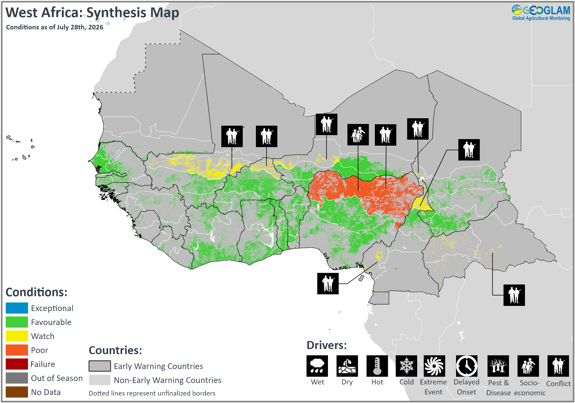
Crop condition map synthesizing crop conditions as of July 28th. Crop conditions over the main growing areas are based on a combination of inputs including remotely sensed data, ground observations, field reports, national, and regional experts. Crops that are in other than favourable conditions are labeled on the map with their driver.
In southern West Africa along the Gulf of Guinea, harvesting of main season cereals is now underway in eastern Liberia, southern Ghana, central and southern Togo, southern Benin, and Nigeria, while planting and development continue elsewhere. Additionally, planting and development of second season maize and rice are underway in south and northern Nigeria, respectively. Along the Sahel, planting and development of main season cereals continue in Senegal, Gambia, Mauritania, Mali, Burkina Faso, Niger, and Chad. Across West Africa, climatic conditions remain generally favourable for crop development despite recent drier than normal conditions along parts of the Sahel and wetter than normal conditions along the Gulf of Guinea. Below-average precipitation has been observed in many Sahelian areas, including in Mali, Niger, and Chad, leading to crop water-requirement deficits and anomalously brown vegetation. Additionally, as of late July, sustained below-average rainfall is resulting in abnormal dryness in southern Mali and central and eastern Liberia. Conversely, isolated above-average precipitation along the Gulf of Guinea in Côte d’Ivoire, Ghana, Togo, Benin, and Nigeria has led to destructive flooding, particularly in late June. According to CHIRPS3.0 rainfall totals from March 1 through July 20, rainfall was up to 500 mm in the southern part of the Sahelian strip and less than 200 mm in its northern part. Conversely, the southern part of the subregion, from southern Guinea to the Central African Republic, received up to 700 mm of rainfall, while coastal areas received more than 1,000 mm. Overall March to June seasonal rainfall totals were mostly average to above average in bimodal areas in the south, and forecasts indicate mixed rainfall outcomes and high temperatures from July through October. El Niño events are typically associated with below-normal June to September rainfall across the Sahel. Current WMO forecasts indicate below-normal rainfall in the western and eastern Sahel and near-normal to above-normal rainfall along the Gulf of Guinea from July through October. Additionally, conflict continues to adversely affect agricultural outcomes in central Mali, northern Burkina Faso, western Niger, the Lac region in Chad, northeastern Nigeria, north and southwestern Cameroon, and the Central African Republic, and socio-economic issues continue to impact northwestern Nigeria. Furthermore, lingering impacts of the war in Ukraine as well as recent tensions in the Middle East have resulted in fuel and fertilizer increases in several countries. Many countries rely on subsidies to support access to agricultural inputs. According to assessments conducted by ECOWAS, the African Union, and their partners, fertilizer supply deficits have been reported in Mali, Burkina Faso, Niger, and Senegal, and markets remain under pressure in Nigeria and Togo despite relatively better availability. There is a high risk of reduced agricultural input use during the 2026/27 cropping season, which could lead to reduced yields and food supply as well as food price inflation.

Middle East & North Africa
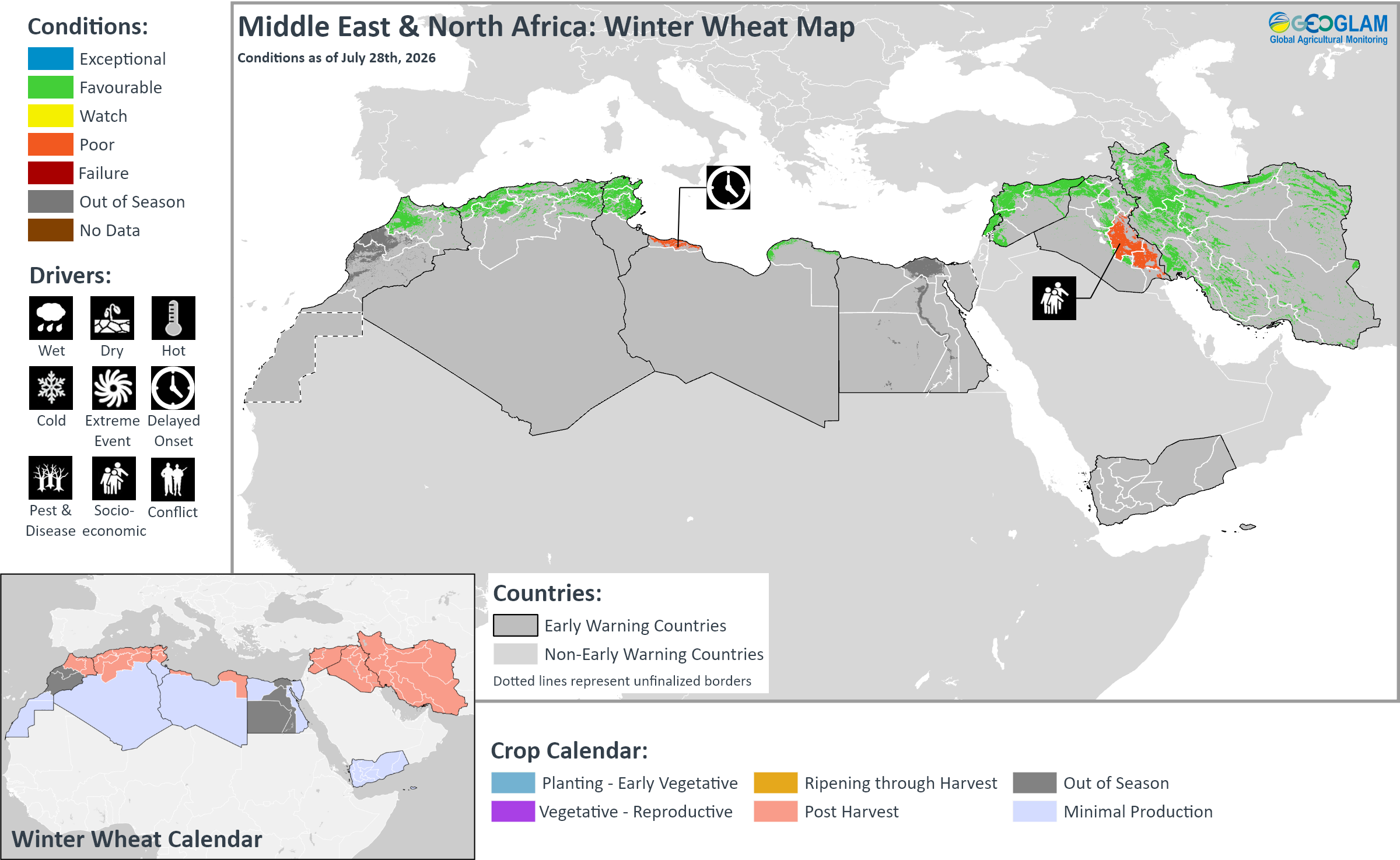
Crop condition map synthesizing Winter Wheat conditions as of July 28th. Crop conditions over the main growing areas are based on a combination of inputs including remotely sensed data, ground observations, field reports, national, and regional experts. Crops that are in other than favourable conditions are labeled on the map with their driver.
Across the Middle East and North Africa, winter wheat harvesting finalized in all regions, including in Morocco, Algeria, Tunisia, Libya, Egypt, Lebanon, Syria, Iraq, and Iran. A generally dry start to the season was followed by rainfall improvements from December 2025 to May 2026 that benefitted winter cereal prospects across most areas. End of season conditions are mostly favourable, except in northwestern Libya where delayed and below-average cumulative rains since the start of the season resulted in failed sowings, and in southern Iraq due to the government’s decision to reduce the area irrigated with surface water by 50 percent.
Additionally, planting and development of rice crops continues in Egypt, Iraq, and Iran under favourable conditions. In Iraq, rice production was authorized in the key producing provinces of the south (mainly in Najaf and Qadissiya as well as in Babil, Wassit, Thi Qar, and Muthanna), and paddy fields were flooded from mid-June to mid-July. In Iran, rice crops are growing well in the main producing northern regions (Gilan, Mazandaran, and Golestan).
In Morocco, dry weather at the start of the season resulted in delayed planting and constrained crop growth, particularly in central and eastern provinces. Conversely, a shift to abundant rains from late November 2025 improved soil moisture and water reservoir levels, which supported crop development from January to April 2026. Despite localized flooding impacts in the northwest, overall 2026 cereal production is forecast at 6.3 million tonnes, representing a 16 percent increase compared to the average and a recovery from prior consecutive drought-affected harvests. In Algeria, dry weather conditions at the start of the season resulted in delayed planting and constrained early crop development in the west. Conversely, a shift to good rains from December 2025 resulted in crop recovery across the country and increased reservoir levels, benefitting irrigation water availability during reproductive stages. In the main producing northeastern areas, including in Constantine and Skikda, above-average rains from January to April 2026 supported favourable yields. Overall 2026 cereal production is forecast at 5 million tonnes, representing a 30 percent increase compared to average and the largest harvest since 2019. However, temperatures 3 to 4°C above average during harvesting time may have a negative impact on grain quality despite good biomass. In Libya, dry weather at the start of the season from October to November 2025 resulted in delayed plantings and a reduction in planted area, particularly in the northwest around Tripoli where biomass is below average, likely due to failed sowings. Conversely, end of season conditions are favourable in the northeast, except in Darnah province where biomass is below average. Overall 2026 cereal production is forecast at 150,000 tonnes, representing a 20 percent decrease compared to average. In Egypt, 2026 wheat production is forecast at 10 million tonnes, representing a 7 percent increase compared to the average. The increase is attributed to government procurement prices announced ahead of the sowing season at more than 30 percent above international wheat prices, which drove an expansion in the planted area. The provision of subsidized certified seeds, fertilizers, and mechanized farming support also benefitted yield outcomes. In Iran, end of season conditions are favourable, except in a localized area in the centre of the country between Tehran and Esfahan where biomass is below average.
Southern Africa
Crop condition map synthesizing wheat conditions as of July 28th. Crop conditions over the main growing areas are based on a combination of inputs including remotely sensed data, ground observations, field reports, national, and regional experts. Crops that are in other than favourable conditions are labeled on the map with their driver.
Across Southern Africa, harvesting of the 2025/26 main season cereals finalized in June, and most areas are now out of season. Planting for the 2026/27 main season will begin in September. El Niño-induced dry spells are forecast across parts of Angola, northern South Africa, and southern Mozambique for the upcoming season. In Zambia, a strong El Niño is expected to bring delayed and below-average rains for the October 2026 to May 2027 rainy season, and the conditions are likely to reduce planted area and agricultural labour opportunities.
In the Democratic Republic of the Congo, harvesting of second season maize is nearing completion, while planting and development of main season cereals is underway, and agro-climatic conditions remain favourable for ongoing cropping activities. Prior dry and hot conditions were followed by rainfall improvements over the last month, particularly in the northeast. However, conflict continues to impact eastern provinces.
Winter wheat crops are in the vegetative to reproductive stage across Zambia, Zimbabwe, South Africa, and Lesotho under favourable conditions. In Zambia, improved soil moisture and surface water reserves have benefitted water availability for the mainly irrigated crop. In Zimbabwe, planted area increased due to good summer rains and increased government support to farmers. Water levels of the Kariba Dam, which supply hydro-electric power for irrigation in Zambia and Zimbabwe, have seen improvement over the summer season, though levels are now starting to decrease with the start of the dry season. Additionally, the government of Zimbabwe has increased investment in the country’s main power plant and continued imports to ensure a more stable power supply for winter wheat producers. Elevated fertilizer and agro-chemical prices have been somewhat mitigated by increased government support. In South Africa, above-normal rain received during autumn and early winter over the main dryland production regions of the Western Cape resulted in very favourable early-season conditions. Dry conditions since the second half of June could negatively affect crop development, though some rain is possible during early August. Over the interior, where mostly irrigated wheat is cultivated, there is ample water in the river systems following a wet summer and autumn period. The preliminary area estimate for wheat is 473,900 hectares, which is 8.39 percent less than the previous season and the smallest planted wheat area since 1929. The reduction in planted area is due to low wheat prices and high fuel and fertilizer costs related to rising tensions in the Middle East, especially at the time of sowing. Fuel and fertilizer accounts for about half of grain production costs for the country, and most are imported.
Central & South Asia
Crop condition map synthesizing wheat conditions as of July 28th. Crop conditions over the main growing areas are based on a combination of inputs including remotely sensed data, ground observations, field reports, national, and regional experts. Crops that are in other than favourable conditions are labeled on the map with their driver.
In Central & South Asia, wheat harvesting finalized last month in Pakistan (Rabi season), and is nearing completion in Afghanistan. Winter wheat harvesting continues in southern Kazakhstan, Kyrgyzstan, Tajikistan, Uzbekistan, and Turkmenistan. Additionally, spring wheat continues to develop across Kazakhstan, Kyrgyzstan, Tajikistan, and Mongolia, and harvesting will begin in August. Overall wheat conditions remain favourable with near-average yields expected.
In Kazakhstan, drought and intense heat affected most regions this summer. However, rainfall improvement in the northern regions of Kostanay and North Kazakhstan mitigated the drought impacts, and conditions remain favourable in the irrigated southern regions with adequate water supplies. Despite the uneven weather conditions and ongoing drought in some regions, including in Akmola, the Ministry of Agriculture reported that most grain crops are in satisfactory condition with adequate moisture reserves in most agricultural regions. Harvesting of winter crops is underway in the south and north, and harvesting progress has reached 635.8 thousand tonnes with a yield of 2.06 tonnes per hectare. However, the country is continuing to diversify its planted area in favour of more profitable crops, such as oilseed, forage crops, and corn, while the wheat area was reduced. In Uzbekistan, near-average March to May rains in key cereal-producing regions improved soil moisture levels and supported crop development. Aggregate 2026 cereal production is forecast at an above-average level of 9 million tonnes, including 7.3 million tonnes of wheat and about 900,000 tonnes of maize. In Kyrgyzstan and Tajikistan, intense rains received in July resulted in flash flooding and mudflows in some areas, though overall conditions remain favourable for ongoing wheat cropping activities. In Afghanistan, 2025/26 wheat harvesting is mostly complete, though some higher elevations will continue harvesting through the end of August and into early September. Overall conditions are generally favourable with a near-normal to normal harvest expected. While localized areas were impacted by a mix of prolonged dry spells, floods, and pest and disease outbreaks, impacts were limited and did not significantly affect overall harvest outcomes. Second season maize and rice crops are developing under favourable conditions, and harvesting will commence in September. Surface water availability is currently sufficient for rice crops, and monsoon rains are supporting standing crops in the east. However, the ongoing heatwave and high evapotranspiration rates will likely result in a shortage of surface water, which will be substituted with groundwater extraction. Maize crops are also developing favourably, particularly in the east, but the ongoing heatwave and moisture stress could affect crops in parts of the south, particularly if dry conditions persist. The ongoing El Niño is expected to bring above-average precipitation across most areas between October 2026 and January 2027, which is likely to support 2026/27 winter wheat planting. In Pakistan, planting of Kharif season rice and main season maize and millet continues under favourable conditions. Sufficient rains and irrigation water availability are supporting rice planting. Conditions also remain favourable for maize planting despite localized heat stress in northern Punjab and Sindh. However, forecast below-average precipitation for the upcoming July to September monsoon season may negatively impact reservoir reserves and irrigation availability.
Southeast Asia
Crop condition map synthesizing rice conditions as of July 28th. Crop conditions over the main growing areas are based on a combination of inputs including remotely sensed data, ground observations, field reports, national, and regional experts. Crops that are in other than favourable conditions are labeled on the map with their driver.
In southern Southeast Asia, planting of dry-season rice is in the final stages, but it is slightly delayed compared to a normal year. Early vegetative growth remains favourable with sufficient irrigation. Harvesting of earlier planted dry-season rice is underway, and yields are expected to be favourable due to adequate irrigation and sunlight. Additionally, harvesting of wet-season maize is nearing completion, while seeding of dry-season maize is underway. Maize growing conditions remain favourable due to adequate irrigation water availability. However, El Niño-induced dry conditions are expected to coincide with the peak of the dry season in Indonesia between July and September (See Regional Outlook Pg. 17).
In northern Southeast Asia, the planted area of wet-season rice is expected to decrease slightly compared to the previous year due to lower rice prices and rising production costs. Wet-season rice is in the tillering to maturing stage, and overall conditions are mixed due to a combination of drought impacts and hot weather in Cambodia, Thailand, and southern Viet Nam as well as rising production costs in Thailand. Additionally, wet-season maize is mainly in the vegetative to flowering stage, and growing conditions are generally favourable due to adequate rainfall and solar radiation, except in Thailand.
Elsewhere in Southeast Asia, including Sri Lanka, Nepal, Bangladesh, and the Democratic People’s Republic of Korea, conditions remain generally favourable, except in eastern Bangladesh where recent heavy monsoon rains have resulted in flash floods and mudslides.
In Indonesia, July is the fourth month of dry-season rice planting. The cumulative planted area reached 3.9 million hectares, which is 6.8 percent lower than the previous dry season, as many farmers are still preparing fields after the wet-season harvest. Early vegetative growth remains favourable with sufficient irrigation in most areas. Harvesting of earlier planted dry-season rice also began in July, and yields are expected to be favourable due to adequate irrigation and sunlight during the flowering stage. Additionally, sowing of dry-season maize entered its fourth month in July, with the total sown area reaching approximately 0.97 million hectares, which is higher than last year. Growing conditions remain favourable due to adequate irrigation water availability. Harvesting of earlier planted dry-season maize also began in July, and yields are expected to be favourable, supported by adequate irrigation water and sufficient sunlight. Despite generally favourable growing conditions, as of early July, El Niño-induced dry conditions were worsening water shortages in parts of Central Java, West Java, East Java, Yogyakarta, and Maluku, coinciding with the peak of the dry season between July and September (See Regional Outlook Pg. 17). In Malaysia, planting of dry-season rice has reached 97 percent of the target planting area. Harvesting has also commenced and currently covers approximately 35 percent of the planted area, with the remaining areas in the late maturity stage. Overall conditions remain favourable for dry-season rice, though some areas may experience below-normal rainfall between July and September due to the ongoing El Niño event, which is expected to strengthen during the second half of 2026 (See Climate Influences Pg. 4 and Regional Outlook Pg. 17). Additionally, harvesting activities for wet-season maize are nearing completion under generally favourable weather conditions. Furthermore, most dry-season maize fields have reached the maturity stage, and harvesting activities are nearing completion under generally favourable conditions. In Brunei, most dry-season rice planted areas are in the reproductive and grain-filling stages, and harvesting of earlier planted crops has just started. Despite a few pest incidences, low precipitation rates and high solar radiation remain conducive for harvesting, and yield prospects remain favourable.
Crop condition map synthesizing maize conditions as of July 28th. Crop conditions over the main growing areas are based on a combination of inputs including remotely sensed data, ground observations, field reports, national, and regional experts. Conditions that are other than favourable are labeled on the map with their driver.
In the Philippines, wet-season rice planted in April to May has reached the maturing stage, and the yield may be higher than last year due to favourable weather during the grain-filling stage. Overall conditions remain favourable for wet-season rice due to sufficient rainfall and adequate water supply from irrigation facilities. Additionally, wet-season maize planted during April to June is currently in the leaf development to kernel formation stage. Crop conditions remain favourable, supported by conducive weather and sufficient irrigation water supply. However, a combination of rising fertilizer and fuel costs as well as a possible El Niño-induced dry spell and related water shortages could result in lower domestic maize production (See Regional Outlook Pg. 17). In response, the country may significantly increase its maize imports. In Thailand, planted area of wet-season rice is expected to decline compared to last year, mainly due to lower rice prices and rising production costs, particularly for fertilizers, pesticides, and fuel. Wet-season rice is currently in the tillering stage, and the yield is expected to decrease as a result of drought conditions and reduced fertilizer application, which may limit crop growth. Consequently, total rice production is projected to be lower than last year. Additionally, planted area of wet-season maize is expected to decline compared with last year, mainly due to rising production costs, particularly for fertilizer and fuel. Wet-season maize is currently in the flowering stage, and dry conditions have adversely affected crop development, resulting in stunted plant growth and incomplete ear formation. The wet-season maize yield and total production are expected to be lower than last year. Conversely, heavy rainfall impacted Phuket province with flooding on July 1, and several provinces across the country experienced continued heavy rains, flash floods, waterlogging, and landslides due to the influence of Tropical Storm Maysak in early July. In northern Viet Nam, dry-season (winter-spring) rice has been fully harvested. The average yield is estimated at approximately 6.53 tons per hectare, which is 0.1 tons per hectare higher than last year. Meanwhile, the wet-season (summer-autumn) rice crop is in the seeding and tillering stages under favourable conditions, supported by adequate irrigation water availability. Additionally, the planted area of dry-season maize reached 314 thousand hectares, a 2.4 percent decline compared with last season. Harvesting of dry-season maize is complete with an average yield of 4.72 tons per hectare, resulting in production of 1.48 million tons, 0.6 percent higher than last season. Meanwhile, the planted area of wet-season maize reached 88 thousand hectares, down 6.8 percent compared with the same period last season. The wet-season maize crop is in the vegetative stage under favourable conditions, supported by adequate rainfall. Tropical Storm Maysak made landfall on July 4 in Mong Cai, located in the northeast of the country, though there were no significant impacts to crop production. In southern Viet Nam, planting progress of wet-season (summer-autumn) rice was slower than in the corresponding period last year due to prolonged hot weather and limited irrigation water availability, prompting farmers to reduce the planted area or delay sowing. Wet-season (summer-autumn) rice is in the young panicle formation to grain-filling stages under favourable conditions. Additionally, planted area of wet-season maize reached 84 thousand hectares, a 3.9 percent increase compared with last season. Wet-season maize is at the flowering stage under favourable conditions due to adequate rainfall and sufficient soil moisture. In lowland areas of Laos, planting of wet-season rice reached 490 thousand hectares, representing 60 percent of the national plan. Planted crops are in the tillering stage, and conditions are favourable for paddy crops in the early growth stage due to adequate rains received, though some areas show crop stress from excess moisture. The average yield is expected to be 3.98 tons per hectare, slightly below last year. In upland areas, planting of wet-season rice reached 61 percent of the national plan. Growing conditions are favourable, and the average yield is expected to be 2.07 tons per hectare. Additionally, planting of wet-season maize reached 33 thousand hectares, representing 31 percent of the national production plan. Crops are nearing the end of the planting to early vegetative stage, and overall conditions remain favourable with adequate soil moisture, as consistent monsoon showers across northern and central provinces are supporting germination and early growth. The average yield potential is at 4.8 tons per hectare, slightly below last year. Production is expected to be over 522 thousand tons. In Myanmar, planting of wet-season rice has reached 1.74 million hectares, accounting for 29 percent of the national plan of 6.04 million hectares. Crops are mostly planted in the Delta region, and planting progress is similar to last year with adequate rains received. Most rice is in the early tillering stage, and overall growing conditions are favourable. Additionally, planting of wet-season maize reached 65 percent of the national plan. Planted maize crops are in the vegetative stage under favourable conditions, with average to above-average rains received and above-average solar radiation rates. However, heavy rainfall and rising river levels in early July affected several areas in Rakhine state. In Cambodia, the planted area of wet-season rice is 2.45 million hectares, representing 83 percent of the national plan. Conditions have been downgraded to watch as hot weather and uneven rainfall caused drought in early July, affecting 3 percent of the cultivated area. According to the National Committee for Disaster Management, El Niño-induced drought affected 108,164 hectares of rice fields in seven provinces, including Banteay Meanchey, Battambang, Pursat, Kampong Cham, Kampong Thom, Siem Reap, and Ratanakkiri. Additionally, the ministry prepared more than 500 water pumps for emergency deployment. The rice yield is expected to be lower than last year due to likely reduced rainfall from July to August (See Regional Outlook Pg. 17). Additionally, the sown area of wet-season maize reached 70 percent of the national plan. Planted maize is in the vegetative to tasselling stage under favourable conditions due to conducive weather and sufficient water supply. According to the United States Department of Agriculture (USDA), maize production is expected to recover to 1.1 million tonnes for the 2026/27 season due to higher maize prices and the availability of hybrid seed, with an average yield projected to reach 5.5 tonnes per hectare. For the previous 2025/26 season, maize production declined 10 percent to 900,000 tonnes due to higher fertilizer and fuel costs, hybrid seed delivery disruptions due to border tensions with Thailand, and planting decision changes.
In Sri Lanka, Yala season rice (40 percent of annual rice output) and Yala season maize (10 percent of annual maize output) continue to develop under favourable conditions, and harvesting will begin in August. In Nepal, planting and development of main season crops continue under favourable conditions. However, a forecast below-average June to September monsoon season may negatively impact ongoing crop production and delay winter wheat planting, which will commence in October. In Bangladesh, harvesting of summer (Kharif) season maize (15 percent of annual maize production) finalized in July under favourable conditions. Additionally, harvesting of Aus season rice (10 percent of annual rice production) is underway, while planting of sorghum and Aman season rice (35 percent of annual rice production) continues, and conditions in the east have been downgraded due to recent heavy precipitation. During July, torrential monsoon rains resulted in flash floods and landslides in several southeast and northeastern areas, including Chattogram, Cox’s Bazar, Bandarban, Rangamati, Khagrachhari, Moulvibazar, and Habiganj districts. In total, approximately 79,500 hectares of Aus season rice and 10,504 hectares of Aman seedbeds have been damaged. In Chattogram and Cox's Bazar districts, the floods damaged 10,915 hectares of Aus season paddy out of 33,473 hectares planted. Additionally, 1,401 hectares of Aman seedbeds out of 3,623 hectares were destroyed. Some paddy seeds will be distributed among affected farmers in phases. In Cumilla district, 66 hectares of transplanted Aman season rice was damaged out of 16,200 hectares cultivated, and transplanted Aus rice recorded particularly severe losses. Rising temperatures in the Bay of Bengal are intensifying rainfall events, making the country particularly vulnerable during monsoon months. In the Democratic People’s Republic of Korea, maize and rice crops are in the vegetative to reproductive stage, and overall growing conditions remain favourable with good rains received.
For detailed description of the pie chart please see description box on the bottom of the page.
Regional Outlook: Substantial rainfall deficits during El Niño 2026
In southeastern mainland areas in Thailand, Cambodia, and Vietnam, in the Philippines, and in southern Indonesia, prevailing drier-than-average conditions led to moderate to severe rainfall deficits, as of July 25th. Below-average rainfall was observed during recent weeks, from June 26th to July 25th, in Thailand, northern and eastern Myanmar, southern Cambodia, central and southern Vietnam, the Philippines, and central and southern Indonesia (Figure 1-left). In Thailand and southern Vietnam, this especially dry period resulted in central and northern areas receiving 30 to less than 75 percent of average rainfall.
Seasonal rainfall deficits are severe in parts of Thailand, central and southern Cambodia, southern Vietnam, and in the northeastern Philippines. April 1st to August 10th rainfall totals in these southeastern mainland deficit areas will likely range from less than 60 to 75 percent of average, even if the forecast above-average rainfall during July 26th to August 10th materializes (Figure 1 middle-left). The persistent drier than average conditions have coincided with typical wet-season crop sowing and early development in Thailand, southern Cambodia, Vietnam, and the Philippines.

The Philippines could observe mixed rainfall conditions in August (Figure 1 middle-right) though below-normal rainfall conditions are forecast to return and continue through September to November 2026 (Figure 1 right). In rainfall deficit areas of Thailand, forecast above-normal next 30-day rainfall totals are largely driven by wetter-than-normal conditions during the first two weeks. SubC models indicate a possible return to below-average rainfall later during mid-late August in these areas.
Indonesia’s 2026 dry season has been intense, with long dry spells and excessive fire hot spots. The extreme dry conditions in southern Indonesia will very likely continue during August to November 2026, according to forecasts for rainfall (Figure 1 middle-right and right), a strong or very strong El Niño, and positive Indian Ocean Dipole conditions. Temperatures have recently been abnormally hot in southern Indonesia and parts of the southeastern mainland, southern Thailand, and in the eastern Philippines. Highly above-average temperatures will very likely be observed in the region into next year.

Figure 1. Recent rainfall, seasonal rainfall outlook, and 1-month and 3-month rainfall probability forecasts.
Figure 1. Left and middle-left: CHC Early Estimates for recent rainfall (left) and an April 1 to August 10 outlook (middle-left). Early Estimates compare current rainfall totals to the 1996–2025 CHIRPS average for the same accumulation period. These use CHIRPS 3 Final data for April to June 2026, Preliminary data for July 1–25, 2026, and a bias-adjusted NCEP GEFS forecast (CHIRPS3-GEFS) for the 16-day forecast from July 26. Middle-right: SubC multimodel 30-day rainfall tercile probability forecast for July 30 to August 28, 2026. Colors show the dominant category forecast by four Subseasonal Consortium models, using terciles identified from 1999–2016 hindcasts. From UCSB CHC SubC. SubC data acquired from the IRI Data Library. Right: ECMWF and NMME 3-month multimodel ensemble forecast rainfall tercile probability for September to November 2026, from UCSB CHC MME.
Source: UCSB Climate Hazards Center
Central America & Caribbean
Crop condition map synthesizing Maize 1 (Primera season) conditions as of July 28th. Crop conditions over the main growing areas are based on a combination of inputs including remotely sensed data, ground observations, field reports, national, and regional experts. Conditions that are other than favourable are labeled on the map with their driver.
In Central America, harvesting of Primera season maize and bean crops is just beginning in Guatemala while crops continue to develop in El Salvador, Honduras, and Nicaragua. Erratic and insufficient rains since the beginning of the season have resulted in planting delays, localized losses, and crop growth disruptions. Phenological stages are varied across production areas, and crops that were delayed may experience problems during grain filling and ear formation. Additionally, high temperatures have further reduced soil moisture levels and irrigation availability. Increased rainfall was received in June but was insufficient to reduce seasonal deficits. As of late July, significant deficits remain across large parts of Guatemala, Honduras, and Nicaragua. Furthermore, high fertilizer costs and reduced application rates are expected to negatively impact yield outcomes for the Primera harvest, particularly for smallholder farmers. Field information indicates worsening maize yields, particularly over the Dry Corridor areas, and potentially the worst conditions in the last 5 to 10 years. Bean conditions are slightly better for medium and large-scale farmers who sowed after recent rains received in late July, as they have access to irrigation infrastructure and beans require less moisture than other crops. Conversely, small-scale farmers that missed the sowing window due to the irregular start to the season are not expected to replant beans.

In Haiti, harvesting of Printemps season maize and bean crops and main season rice crops continues, and conditions have been upgraded to favourable. Crop development is normal despite persistent rainfall deficits for more than two consecutive months, particularly in the Ouest and Sud-Ouest, likely due to the use of irrigation. Additionally, planting of Été season maize and bean crops is just beginning under favourable agro-climatic conditions. However, forecast below-average rains and high temperatures could delay planting activities and increase moisture stress on newly established crops, potentially resulting in slightly below-average production as areas that usually capture water may not fully be able to recover. Throughout the country, agricultural production remains limited due to high costs and protracted insecurity, including two separate waves of armed violence that impacted the Ouest department in July. In Cuba, planting and development of main season rice continues, and despite generally favourable agro-climatic conditions, ongoing extreme fuel shortages since January continue to impact agricultural production and have reduced overall food output by 60 percent.
For detailed description of the pie chart please see description box on the bottom of the page.
Pie Chart Description: Each slice represents a country’s share of total regional production. The proportion within each national slice is colored according to the crop conditions within a specific growing area; grey indicates that the respective area is out of season. Sections within each slide are weighted by the sub-national production statistics (5-year average) of the respective country. The section within each national slice also accounts for multiple cropping seasons (i.e. spring and winter wheat) and are a result of combining totals from multiple seasons to represent the total yearly national production. When conditions are other than favourable icons are added that provide information on the key climatic drivers affecting conditions.
Information on crop conditions in the main production and export countries can be found in the Crop Monitor for AMIS, published August 6th, 2026.
Sources and Disclaimers: The Crop Monitor assessment is conducted by GEOGLAM with inputs from the following partners FEWS NET, JRC, WFP, ARC, AFSIS, MESA, ICPAC, FAO GIEWS, Applied Geosolutions and UMD. The findings and conclusions in this joint multi-agency report are consensual statements from the GEOGLAM experts, and do not necessarily reflect those of the individual agencies represented by these experts.