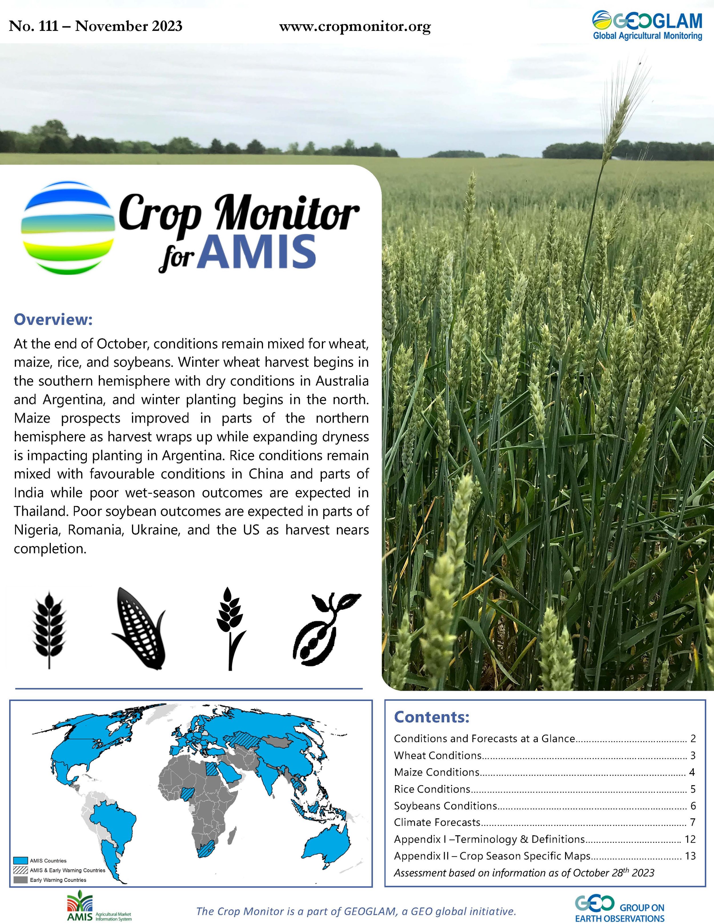
Crop Monitor for AMIS
Report Information
No. 111: Published November 2nd, 2023
Conditions as of October 28th
For access to all reports, please visit the Archive.
Overview
At the end of October, conditions remain mixed for wheat, maize, rice, and soybeans. Winter wheat harvest begins in the southern hemisphere with dry conditions in Australia and Argentina, and winter planting begins in the north. Maize prospects improved in parts of the northern hemisphere as harvest wraps up while expanding dryness is impacting planting in Argentina. Rice conditions remain mixed with favourable conditions in China and parts of India while poor wet-season outcomes are expected in Thailand. Poor soybean outcomes are expected in parts of Nigeria, Romania, Ukraine, and the US as harvest nears completion.
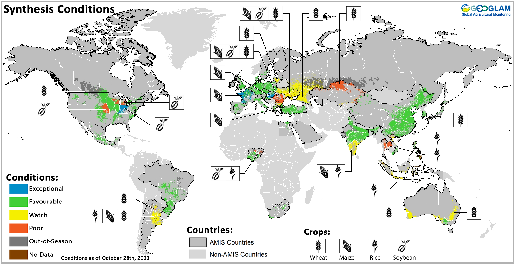
Crop condition map synthesizing information for all four AMIS crops as of October 28th. Crop conditions over the main growing areas for wheat, maize, rice, and soybean are based on a combination of national and regional crop analyst inputs along with earth observation data. Crops that are in other than favourable conditions are displayed on the map with their crop symbol.
Crop Conditions at a Glance
Wheat – In the southern hemisphere, dryness persists in parts of Australia and Argentina as winter harvest begins. In the northern hemisphere, winter planting begins under mixed conditions.
Maize – In the northern hemisphere, harvest is nearing completion with improvement in parts of the Russian Federation, US, and Mexico. Planting is ramping up in the southern hemisphere with expanding dryness in Argentina.
Rice – In China, harvesting conditions are favourable for both single and late-season crops. In India, Kharif conditions remain favourable except in the south. In Southeast Asia, poor wet-season outcomes are expected in Thailand, and limited rains are impacting planting in Indonesia.
Soybeans – In the northern hemisphere, harvesting is nearing completion under mixed conditions with poor outcomes expected in parts of Nigeria, Romania, Ukraine, and the U.S.
Forecasts at a Glance
Climate Influences – El Niño is currently present, and models predict a strong intensity during November to January. The ongoing positive Indian Ocean Dipole (IOD) event increased to a strong level of intensity during recent weeks.
Argentina – Above-average precipitation is likely through January 2024 across much of the east, including the major producing regions, and above-average temperatures are expected in the northern half of the country, particularly in the northwest.
Brazil – Through January 2024, below-average rainfall is expected across much of the north and northeast, above-average rainfall is likely across the centre and south, and above-average temperatures are likely in all regions.
The United States – Above-average precipitation is likely through early November in most areas except along the Southwest. Above-average rainfall is expected for the November-December-January period along much of the southeast.
Wheat Conditions
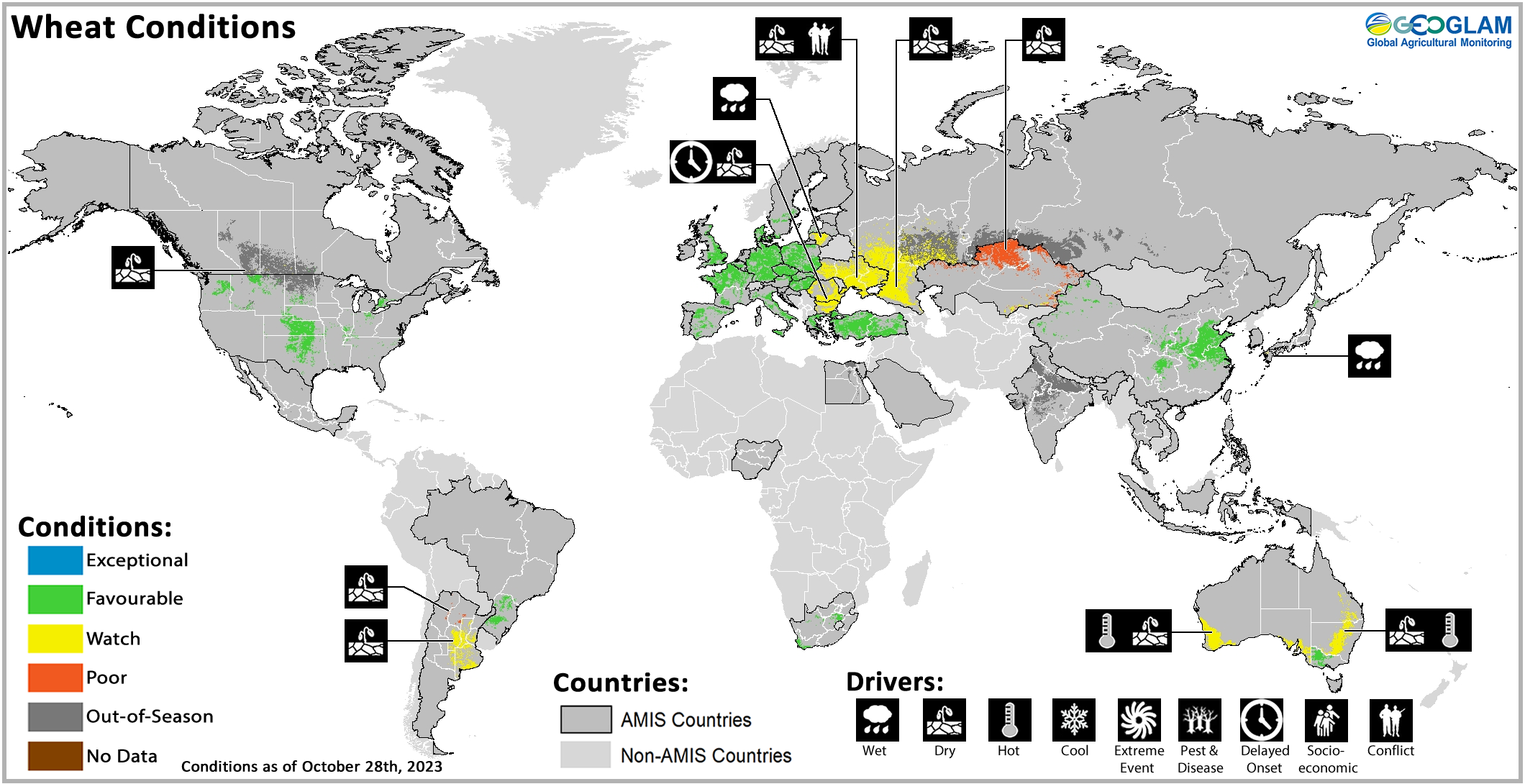

Wheat crop conditions over main growing areas are based upon a combination of national and regional crop analyst inputs along with earth observation data. Crop condition information is based upon information as of October 28th. Where crops are in other than favourable conditions the climatic drivers responsible for those conditions are displayed. For detailed description of the pie chart please see box at the bottom of the page.
Wheat: In Australia, hot and dry conditions in the east and west are likely to reduce yields to below-average levels. In Argentina, conditions have deteriorated due to inadequate soil moisture with yields likely to be affected. In the EU, winter wheat planting continues with concern in Bulgaria and Romania due to dry and hard topsoil and in Lithuania due to wet conditions. In the UK, conditions are favourable for the start of winter sowing. In Türkiye, rains received in October have established favourable soil moisture for sowing and germination. In Ukraine, limited October rains mostly abated drought and were conducive for planting, though dryness remains a concern for crop emergence. In the Russian Federation, insufficient precipitation in October increased dryness, especially in the Volga region, though cooler temperatures helped to lessen some of the dry impacts. In China, winter planting begins under favourable conditions. In the US, dry conditions favoured winter wheat planting, and warm weather promoted emergence and establishment. In Canada, winter wheat planting is now underway with concern in Alberta and Saskatchewan due to fall drought conditions, raising concern for crop emergence.
Maize Conditions
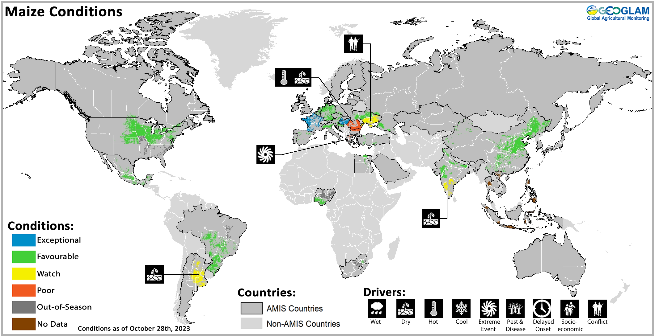
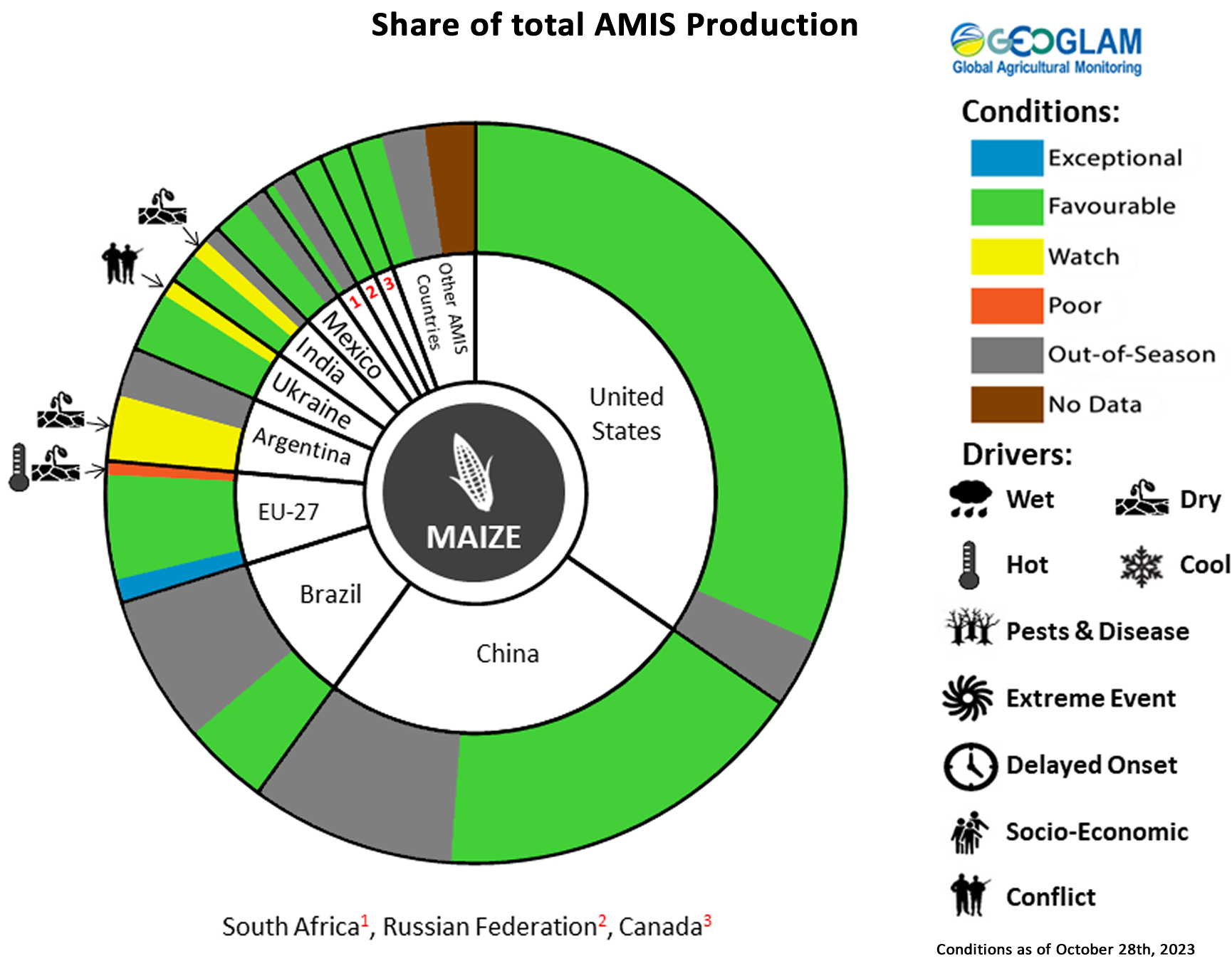
Maize crop conditions over main growing areas are based upon a combination of national and regional crop analyst inputs along with earth observation data. Crop condition information is based upon information as of October 28th. Where crops are in other than favourable conditions the climatic drivers responsible for those conditions are displayed. For detailed description of the pie chart please see box at the bottom of the page.
Maize: In the US, crops have improved from previous dryness with near-average yields expected. In Mexico, overall prospects are favourable despite below-average rains received in many areas. In Canada, harvesting continues under favourable conditions despite localized drought impacts in Manitoba and early season dryness in Ontario. In China, harvesting of both the spring and summer-planted crops finalized under favourable conditions despite below-average rains received along the north. In India, harvesting conditions are favourable except in the south where delayed and erratic monsoon rains led to prolonged dry spells. In the EU, conditions are mixed with poor outcomes expected in Greece due to flood events and in Bulgaria and Romania due to the rainfall deficit and high daily temperatures. In Ukraine, harvesting is underway with a higher yield than last year in non-occupied regions. In the Russian Federation, harvesting finalized under favourable conditions despite dry impacts in the southwest. In Brazil, sowing of the spring-planted crop (smaller season) is ramping up with good soil moisture in the main producing South region. In Argentina, a lack of rainfall is delaying sowing of the early planted crop (usually larger season) in almost all growing regions.
Rice Conditions

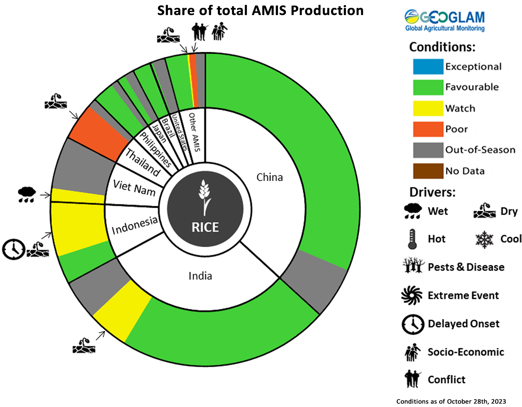
Rice crop conditions over main growing areas are based upon a combination of national and regional crop analyst inputs along with earth observation data. Crop condition information is based upon information as of October 28th. Where crops are in other than favourable conditions the climatic drivers responsible for those conditions are displayed. For detailed description of the pie chart please see box at the bottom of the page.
Maize: In the US, crops have improved from previous dryness with near-average yields expected. In Mexico, overall prospects are favourable despite below-average rains received in many areas. In Canada, harvesting continues under favourable conditions despite localized drought impacts in Manitoba and early Rice: In China, harvesting of the single-season crop finalized under favourable conditions despite previous dry and hot weather in the south and southwest. In India, the late monsoon rains postponed the start of the Kharif season in the south. Elsewhere, conditions are favourable as harvest begins in the north. In Indonesia, wet-season rice planting is progressing at a slow pace due to limited rainfall received. Dry-season rice harvesting is favourable. In northern Viet Nam, wet-season rice yields are expected to decrease due to heavy rain and flooding in the central region. In the south, the other wet-season (autumn-winter and seasonal) rice is under favourable conditions. In Thailand, conditions have been downgraded due to the impacts of drought early in the season as well as recent prolonged flooding. In the Philippines, wet-season rice conditions are favourable despite the passage of two tropical cyclones that brought heavy rains to parts of Luzon. In Japan, harvesting finalized under favourable conditions despite limited sunlight, record high temperatures, and limited rains received during parts of the season. In Brazil, sowing of the mostly irrigated crop continues under favourable conditions. In the US, harvesting finalized under favourable conditions.
Soybean Conditions

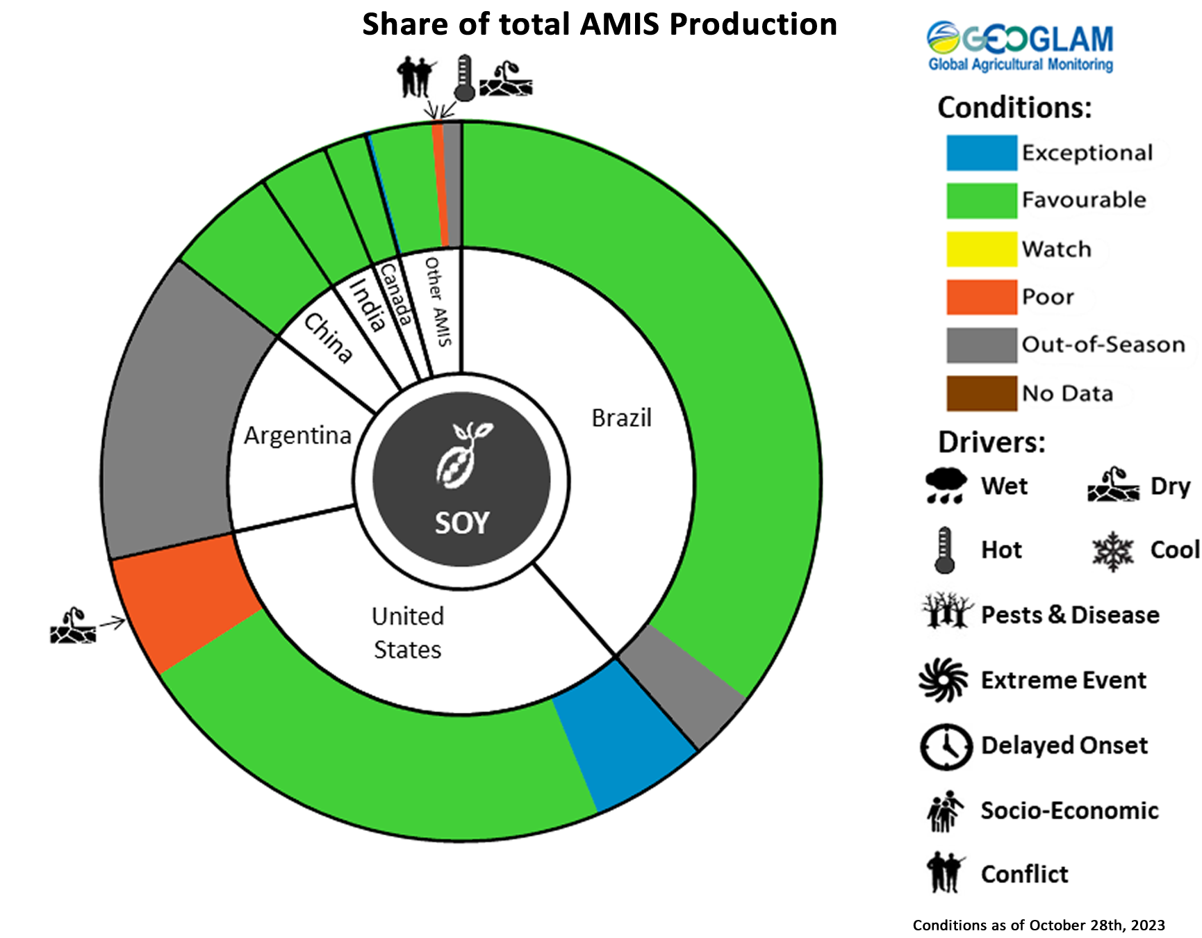
Soybean crop conditions over main growing areas are based upon a combination of national and regional crop analyst inputs along with earth observation data. Crop condition information is based upon information as of October 28th. Where crops are in other than favourable conditions the climatic drivers responsible for those conditions are displayed. For detailed description of the pie chart please see box at the bottom of the page.
Soybeans: In the US, harvesting finalized under mixed conditions as pervasive dryness impacted some north-central areas, though yields are expected to be average at the national level. In Canada, harvesting continues under favourable conditions with improvement in Quebec despite crop disease in some fields. In China, harvesting finalized under favourable conditions with improvement in the south and southwest. In India, following a dry spell in August, enhanced rains in September led to crop recovery. In Ukraine, harvesting is mostly complete under favourable conditions except in conflict-affected areas. In Brazil, sowing activities are slightly delayed due to excessive rains in the South region and limited precipitation in unirrigated areas, but conditions remain favourable.
Pie chart description: Each slice represents a country's share of total AMIS production (5-year average). Main producing countries (representing 95 percent of production) are shown individually, with the remaining 5 percent grouped into the “Other AMIS Countries” category. The proportion within each national slice is coloured according to the crop conditions within a specific growing area; grey indicates that the respective area is out of season. Sections within each slide are weighted by the sub-national production statistics (5-year average) of the respective country. The section within each national slice also accounts for multiple cropping seasons (i.e., spring and winter wheat). When conditions are other than’ favourable’, icons are added that provide information on the key climatic drivers affecting conditions.
Information on crop conditions in non-AMIS countries can be found in the GEOGLAM Crop Monitor for Early Warning, published November 2nd
Global Two-week Forecast of Areas with Above or Below-Average Precipitation
The ongoing El Niño event will likely reach a strong level of intensity during November 2023 to January 2024 (75 percent chance), then weaken and remain active into March to May 2024 (80 percent chance), according to the IRI/CPC forecast.
El Niño events tend to enhance precipitation in Central Asia, southern North America, south-eastern South America, east and southern East Africa, and south-eastern China. Drier-than-average conditions tend to occur in Central America, northern South America, parts of the northern U.S. and Canada, Southern Africa, Northern China, the Maritime Continent, and Australia.
The ongoing positive Indian Ocean Dipole (IOD) event increased to a strong level of intensity during recent weeks. The IOD will likely remain positive through at least December, according to the Australian Bureau of Meteorology. These conditions tend to enhance the drying influences of El Niño in Australia and the Maritime Continent, and substantially increase the chances of a wet and intense East Africa short rains season.
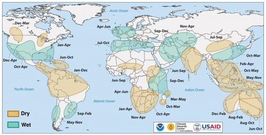
Location and timing of likely above- and below-average precipitation related to El Niño events. Based upon observed precipitation during 22 El Niño events since 1950, wet and dry correspond to a statistically significant increase in the frequency of precipitation in the upper and lower thirds of historical values, respectively. Statistical significance at the 95% level is based on the resampling of precipitation during neutral El Niño-Southern Oscillation conditions. Source: FEWS NET & NOAA & CHC
Global Two-week Forecast of Areas with Above or Below-Average Precipitation
The two-week forecast (Figure 1) indicates a likelihood of above-average rainfall over much of the US, southern Mexico, Cuba, the Dominican Republic, southern Peru, southwestern Bolivia, northern Argentina, Uruguay, the southern tip of Brazil, the Gulf of Guinea countries, much of East Africa, northwestern parts of Southern Africa, Madagascar, Ireland, the United Kingdom, France, Belgium, the Netherlands, Germany, southern Norway, Sweden, Finland, Lithuania, Ukraine, Romania, Türkiye, much of the Middle East, Afghanistan, Pakistan, central and eastern parts of the Russian Federation, Mongolia, west and northeastern China, Sri Lanka, Japan, the Democratic People’s Republic of Korea, the Republic of Korea, Cambodia, and eastern Australia.
There is also a likelihood of below-average rainfall over much of Canada, central Mexico, Ecuador, Colombia, Venezuela, Guyana, Suriname, French Guiana, much of Brazil, northern Peru, Bolivia, Paraguay, Chile, Argentina, western parts of North Africa, Senegal, Gambia, Mali, Guinea-Bissau, Guinea, Sierra Leone, southern parts of Southern Africa, Portugal, Spain, central and Caucasus areas in the Russian Federation, Kazakhstan, Uzbekistan, Kyrgyzstan, Tajikistan, much of China, India, Bangladesh, Myanmar, Malaysia, Indonesia, Papua New Guinea, much of Australia, and New Zealand.

Figure 1: IRI SubX Precipitation Biweekly Probability Forecast for 4 – 17 November 2023, issued on 27 October 2023. The forecast is based on statistically calibrated tercile category forecasts from three SubX models. Source: IRI Subseasonal Forecasts Maproom
Argentina Outlook
The 1 to 7 November precipitation anomaly forecast (left) indicates a likelihood of below-average rainfall over most north and central areas, particularly along the northern border from Salta extending eastwards through Corrientes. During the same period, below-normal temperatures are expected for most areas, particularly in eastern Cordoba, central Santa Fe, and western Entre Rios.
The 8 to 14 November precipitation anomaly forecast (centre) shows below-average rainfall is expected in northern Cordoba, southern Santa Fe, and parts of Buenos Aires while above-average rainfall is likely from Jujuy extending eastwards across the northern border and southwards into Entre Rios. During the same period, above-average temperatures are expected along the northern border regions while below-average temperatures are likely along the centre and south.
The long-term November-December-January 2024 precipitation anomaly forecast (right) indicates a likelihood of below-average rainfall over the northwest and south while above-average rainfall is expected across the east, particularly in the northeast. During the same time, above-average temperatures are expected across the northern half of the country, particularly in the northwest.
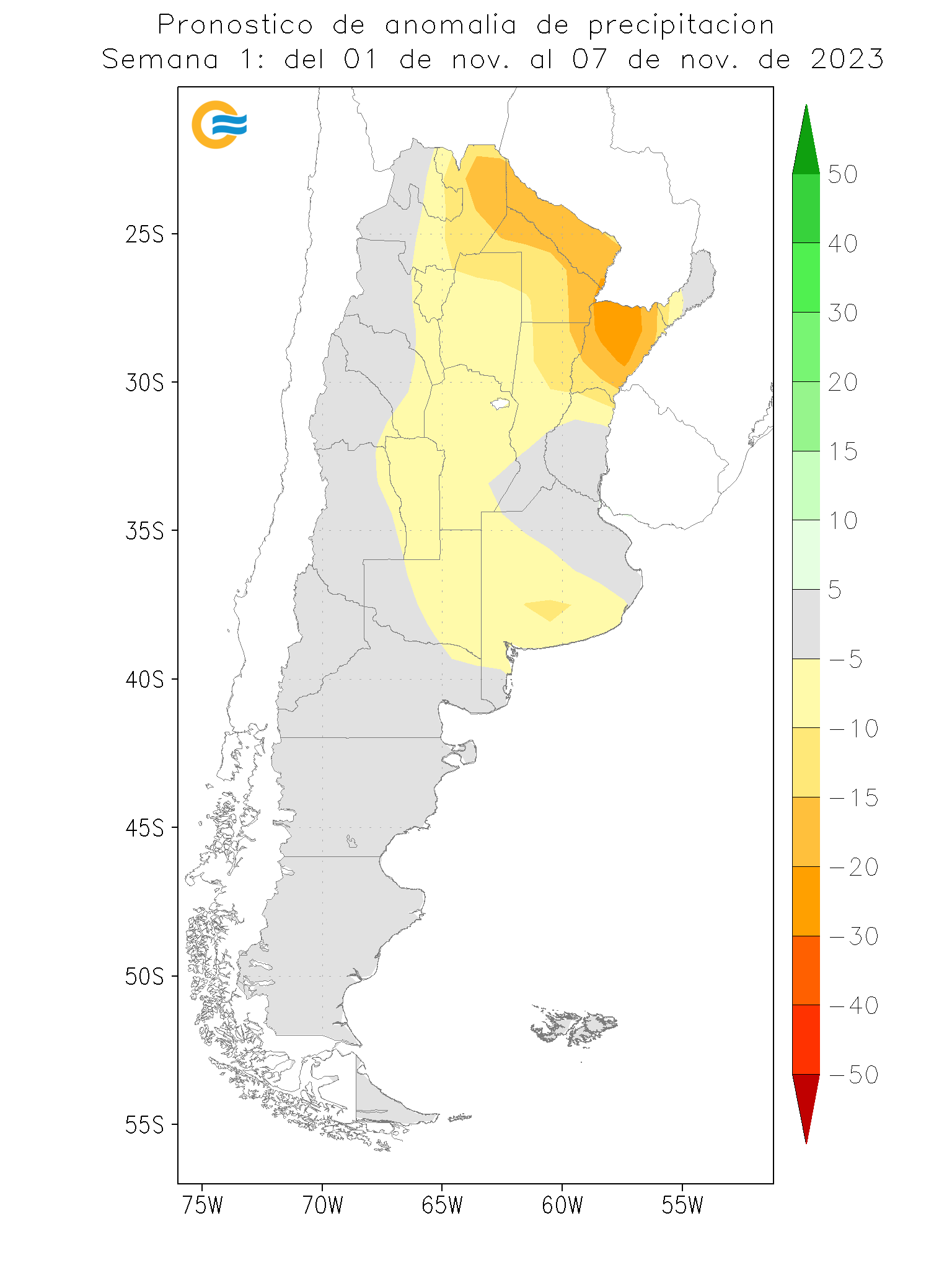
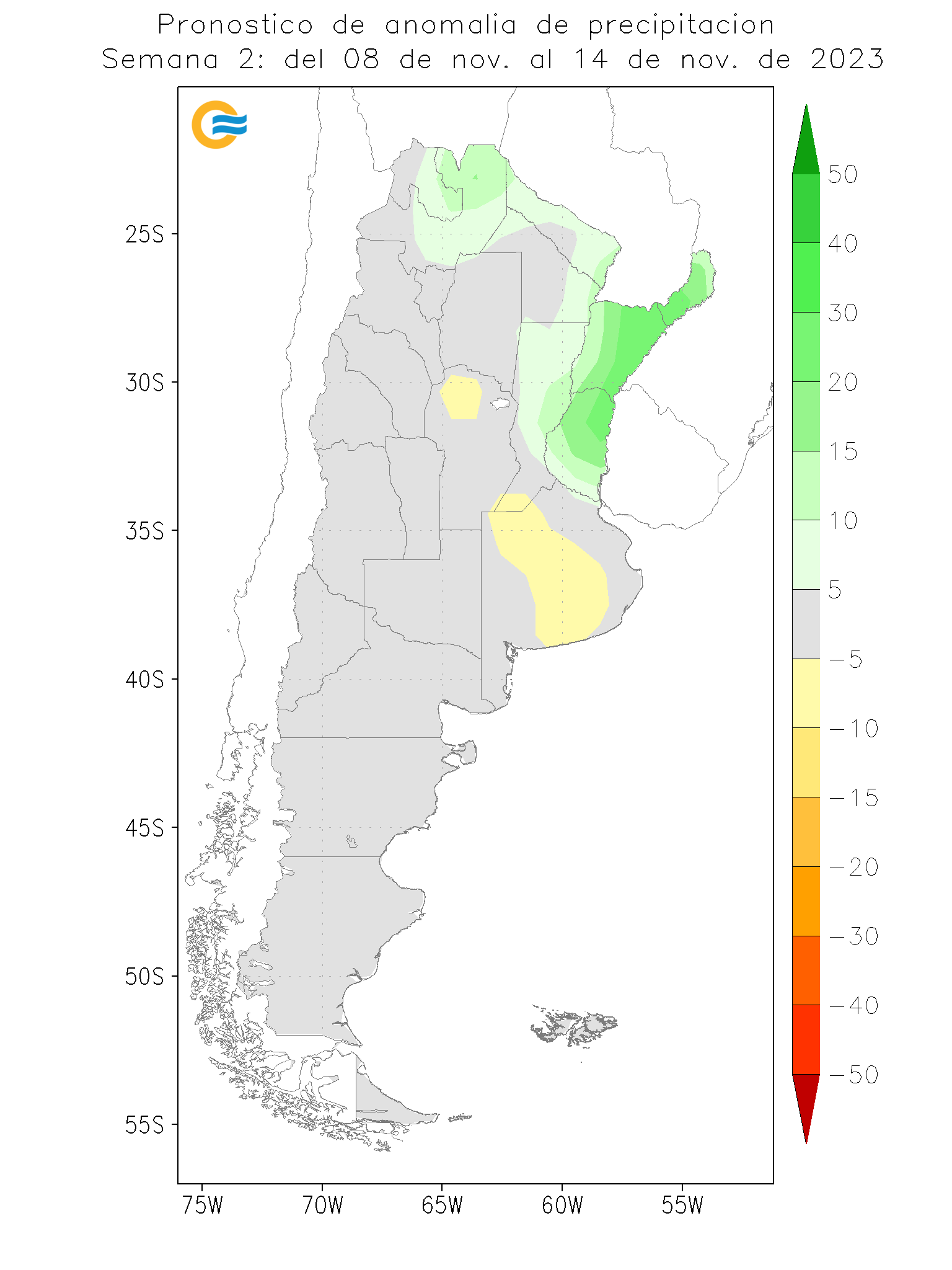
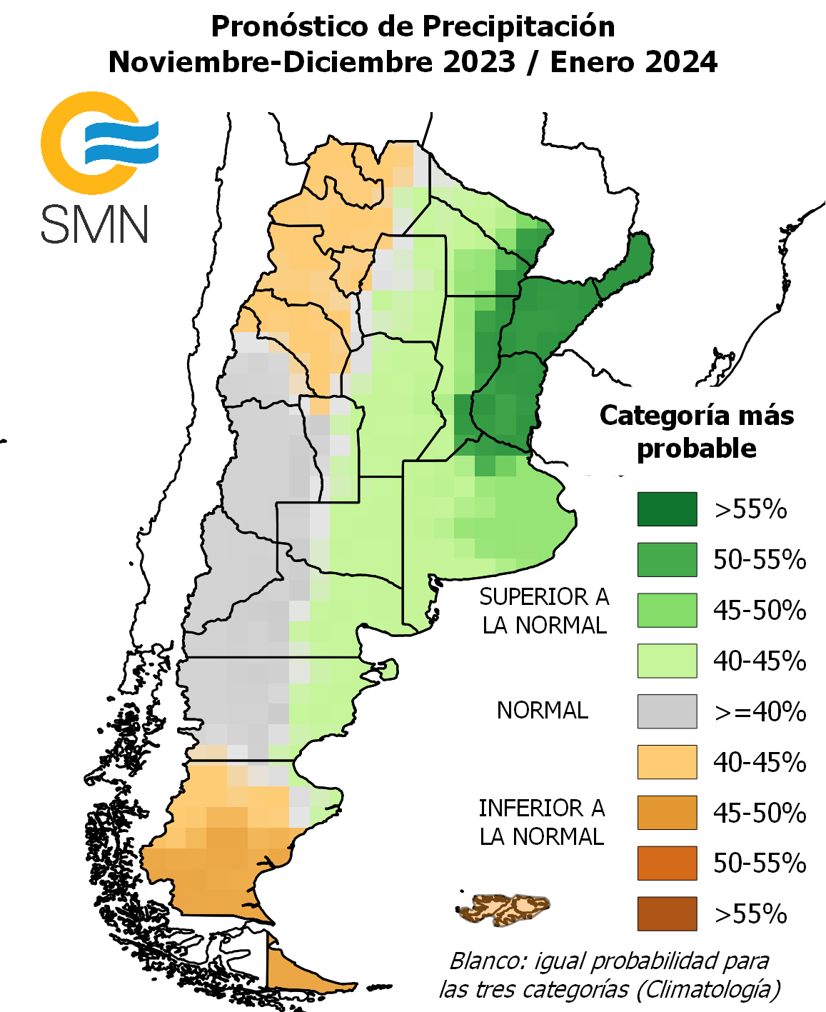
Left: 1 – 7 November 2023 forecast precipitation anomaly in mm. Centre: 8 – 14 November 2023 forecast precipitation anomaly in mm. Images from the National Meteorological Service of Argentina. Right: November-December-January 2023 forecast rainfall anomaly. Image from the National Meteorological Service of Argentina.
Brazil Outlook
The long-term November-December-January 2023/2024 precipitation anomaly forecast (left) indicates a likelihood of below-average rainfall across much of the north and northeast, from Amazonas extending eastwards to Ceara and southwards into Espirito Santo. Above-average rainfall is expected over most central and southern areas as well as in Acre and eastern parts of Paraiba, Pernambuco, Alagoas, and Sergipe.
The long-term November-December-January 2023/2024 temperature anomaly forecast (right) indicates a likelihood of mostly above-average temperatures, particularly along parts of the north and in Piaui.


Left: November-December-January 2023/2024 precipitation anomaly forecast, issued in October 2023. Right: November-December-January 2023/2024 temperature anomaly forecast, issued in October 2023. Images from the National Institute of Meteorology
United States Outlook
The 6 to 10 November outlook indicates a likelihood of above-average rainfall across the west, centre, and east, particularly in the Pacific, Dakotas, Corn Belt, and northeast. Below-average rains are expected along the southwest. During the same period, above-average temperatures are likely from the Pacific Northwest and extending through the southeast, particularly along parts of California, Arizona, New Mexico, and Texas, while below-average temperatures are likely from the Midwest through the Corn Belt and into the northeast.
For the long-term seasonal November-December-January outlook, below-average rainfall is expected along parts of the north and Lake States while above-average rainfall is likely across much of the southeast from Texas to New Jersey. During the same period, above-normal temperatures are expected along the northern half of the country, particularly in the northwest and northeast.

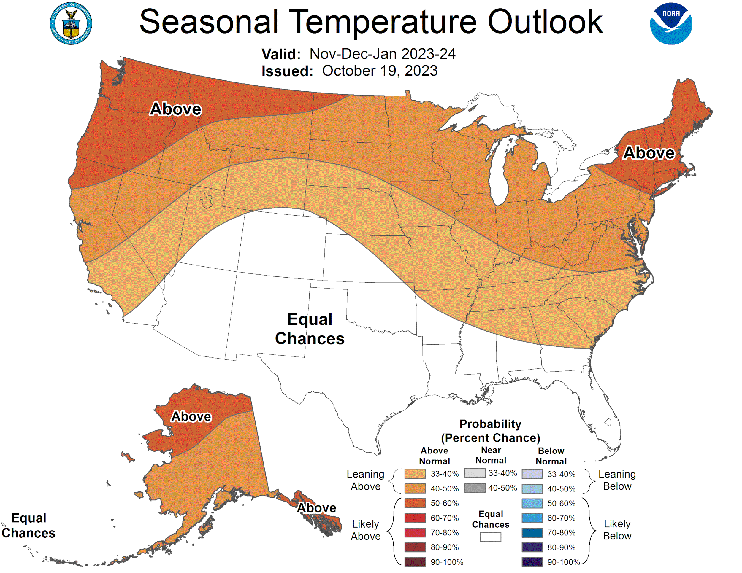
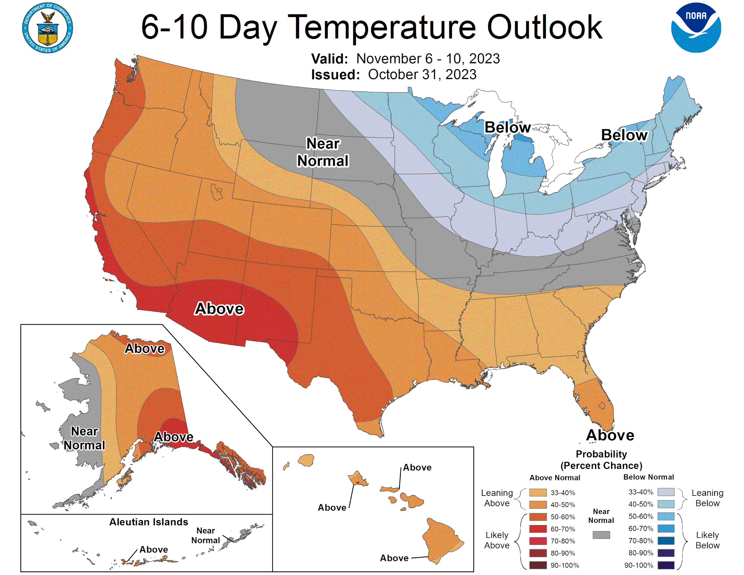
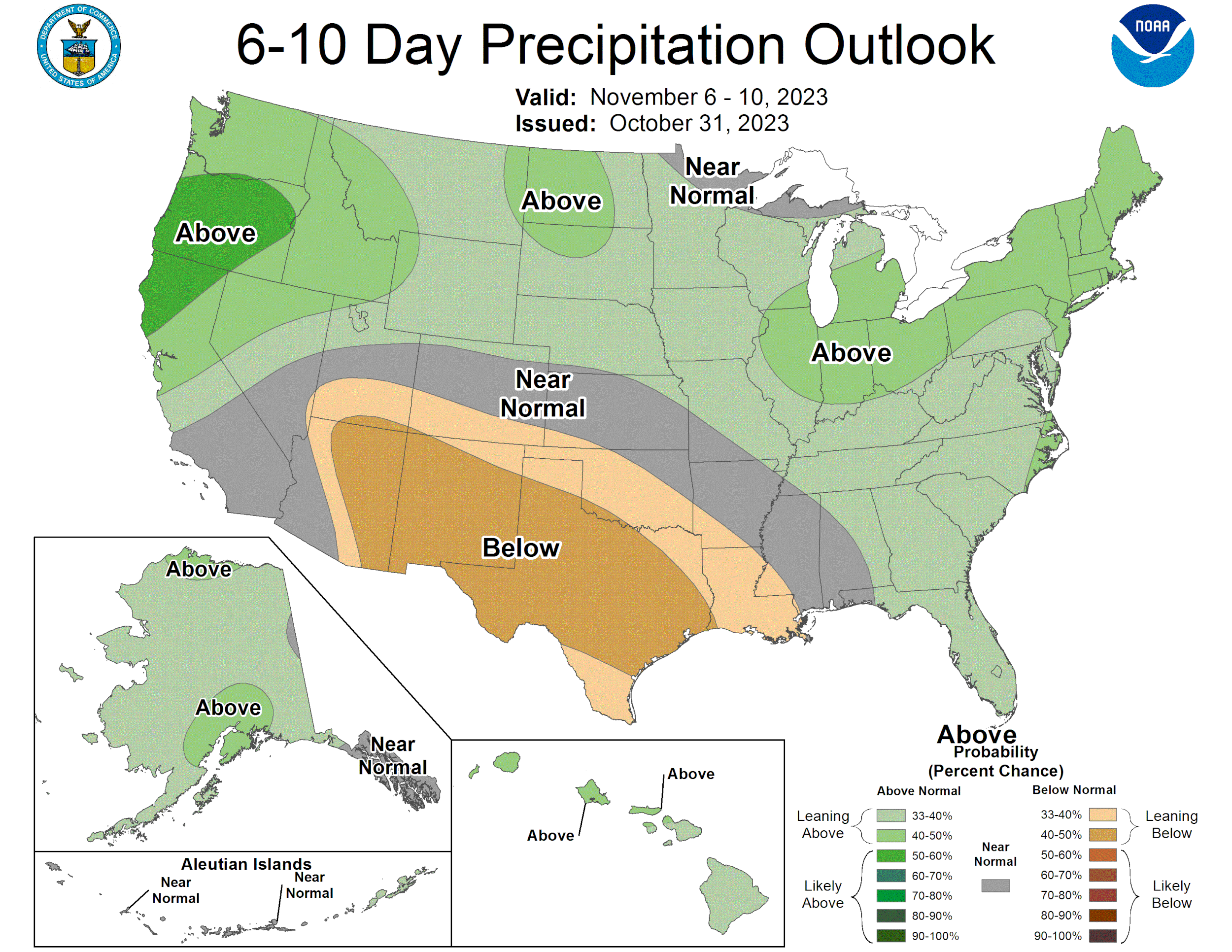
Upper Left: 6 – 10 day precipitation outlook issued on 31 October 2023. Upper Right: 6 - 10 day temperature outlook issued on 31 October 2023. Lower Left: Extended November-December-January precipitation outlook issued on 19 October 2023. Lower Right: Extended November-December-January temperature outlook issued on 19 October 2023. Maps from NOAA/National Weather Service, National Centers for Environmental Predictions, and Climate Prediction Center https://www.cpc.ncep.noaa.gov/products/forecasts/.
Source: NOAA Climate Prediction Center