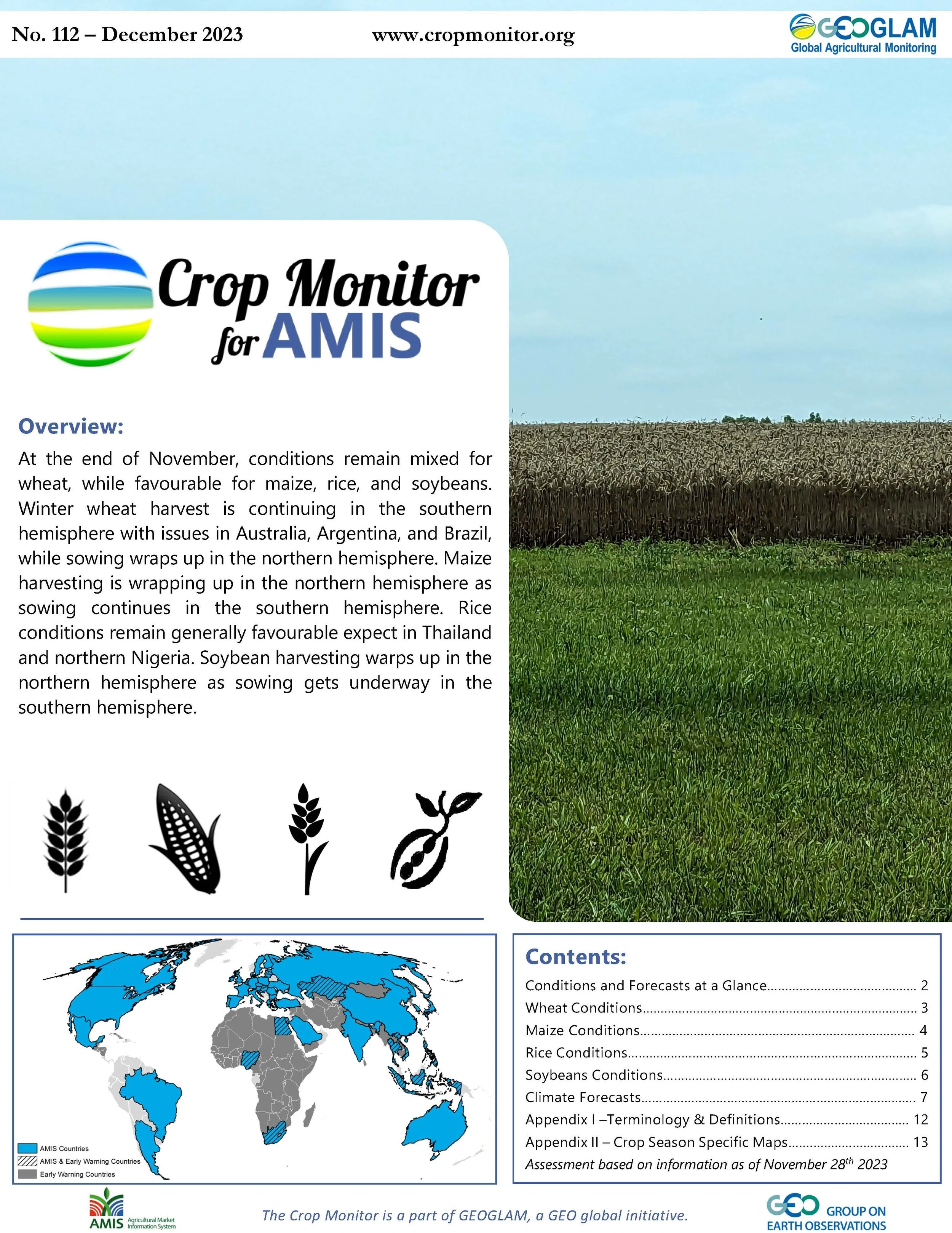
Crop Monitor for AMIS
Report Information
No. 112: Published December 7th, 2023
Conditions as of November 28th
For access to all reports, please visit the Archive.
Overview
At the end of November, conditions remain mixed for wheat, while favourable for maize, rice, and soybeans. Winter wheat harvest is continuing in the southern hemisphere with issues in Australia, Argentina, and Brazil, while sowing wraps up in the northern hemisphere. Maize harvesting is wrapping up in the northern hemisphere as sowing continues in the southern hemisphere. Rice conditions remain generally favourable expect in Thailand and northern Nigeria. Soybean harvesting warps up in the northern hemisphere as sowing gets underway in the southern hemisphere.
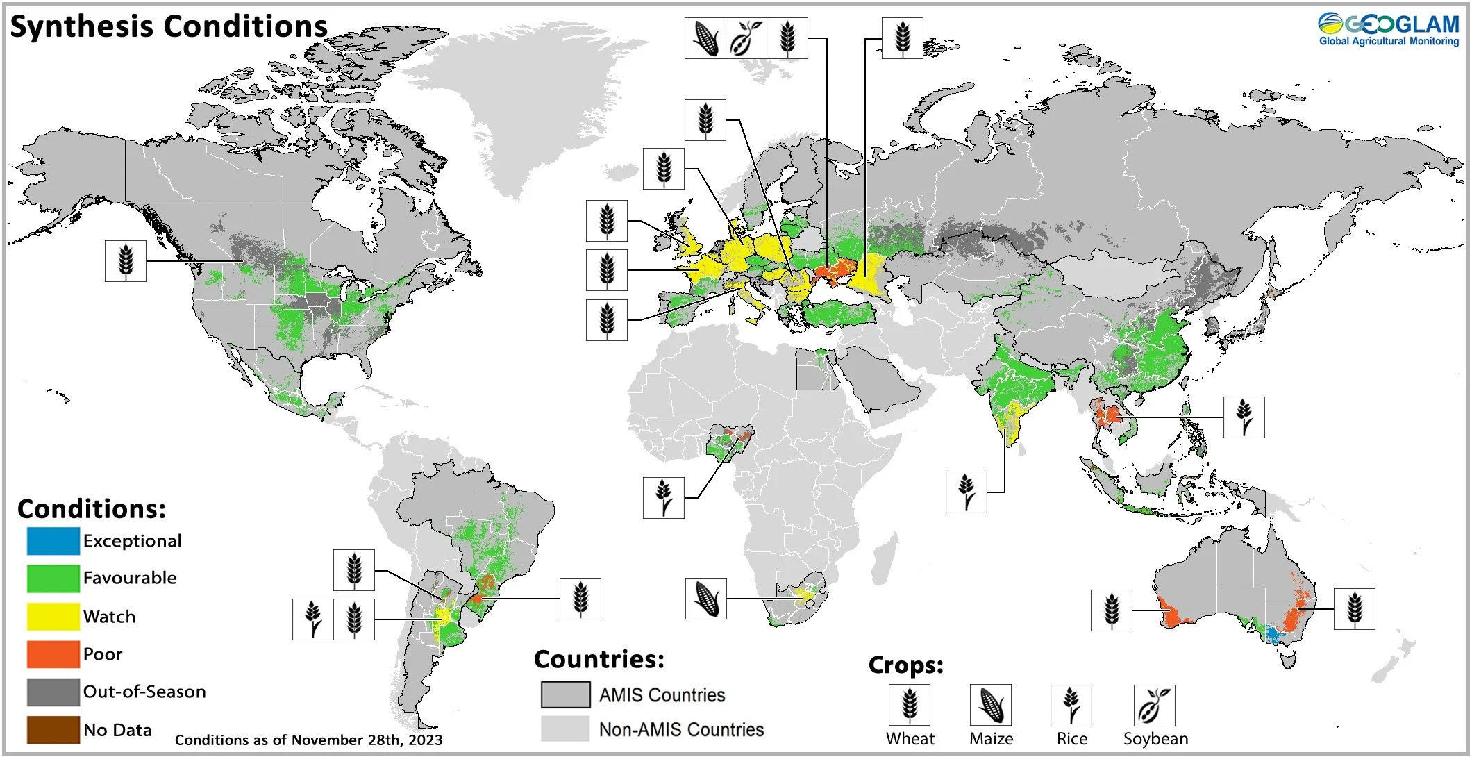
Global crop condition map synthesizing information for all four AMIS crops as of November 28th. Crop conditions over the main growing areas for wheat, maize, rice, and soybean are based on a combination of national and regional crop analyst inputs along with earth observation data from all Crop Monitors. Crops that are in other than favourable conditions are displayed on the map with their crop symbol.
Crop Conditions at a Glance
Wheat – In the southern hemisphere, harvesting is continuing with areas of concern in Australia, Argentina, and Brazil. In the northern hemisphere, winter sowing is wrapping up under mixed conditions, particularly in Europe and the Black Sea region.
Maize – In the northern hemisphere, harvest is wrapping up under generally favourable conditions. In the southern hemisphere, sowing of spring-planted crops is progressing.
Rice – In China, harvesting late-season rice. In India, harvesting of Kharif rice continues. In Southeast Asia, wet-season rice is harvesting in the northern countries, while in Indonesia, dry-season rice harvesting is wrapping up.
Soybeans – In the northern hemisphere, harvesting is wrapping up. In the southern hemisphere, sowing is gathering pace in Argentina and Brazil after initial delays.
Forecasts at a Glance
Climate Influences – The ongoing El Niño is developing into a strong event and is likely to maintain strength into early 2024. El Niño conditions will likely continue into March to May 2024 (88% chance) and transition to ENSO-neutral by May to July (55% chance). The ongoing strong positive Indian Ocean Dipole (IOD) event will likely weaken in December but last into January.
Argentina – Both the short-term (2 weeks) and the long-term (3 months) forecasts show a likelihood of above-average precipitation over the main growing regions.
Brazil – In December, below-average rainfall is likely in parts of the north and northeast combined with above-average temperatures. The long-term forecast (December-February) indicates below-average precipitation in the north, while above-average precipitation across much of the rest of the country.
Wheat Conditions
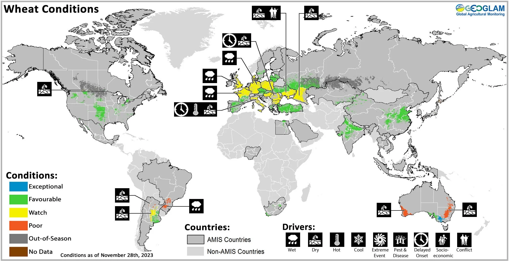
Wheat crop conditions over main growing areas are based upon a combination of national and regional crop analyst inputs along with earth observation data. Crop condition information is based upon information as of November 28th. Where crops are in other than favourable conditions the climatic drivers responsible for those conditions are displayed. For detailed description of the pie chart please see box at the bottom of the page.
Wheat: In Australia, harvesting is ongoing under mixed conditions as hot and dry weather eroded yields across much of the country, however, timely October rains supported grain filling in Victoria and South Australia. In Argentina, harvesting is beginning in the north as recent rains have arrived too late for most of the crops, however, conditions have improved in Buenos Aires. In the EU, wetter than average conditions in western and northern Europe have delayed sowing and crop establishment, while dryness in south-east countries has led to poor development. In the UK, abundant rainfall has resulted in late sowing and may affect early crop development. In Türkiye, sowing is wrapping up under favourable conditions. In Ukraine, sowing is wrapping up under favourable conditions away from the conflict zones owing to warmer and wetter-than-average weather during November, while drought persists in Odessa. In the Russian Federation, November rains have improved conditions across most regions except for in the Caucasus. In China, conditions are favourable going into winter dormancy. In India, sowing is progressing in the northern and central states under favourable conditions. In the US, dry weather has continued to support winter wheat sowing. In Canada, winter wheat conditions are favourable in the main producing provinces of Ontario and Manitoba.
Maize Conditions
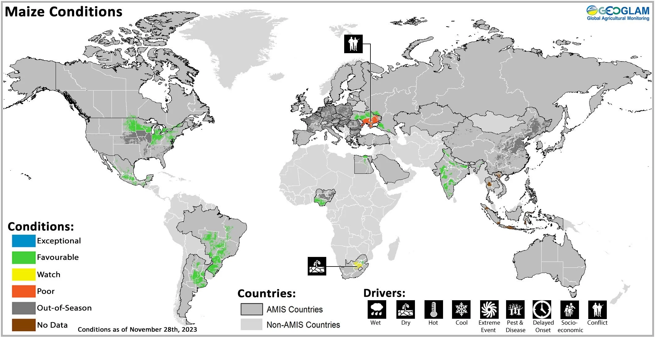
Maize crop conditions over main growing areas are based upon a combination of national and regional crop analyst inputs along with earth observation data. Crop condition information is based upon information as of November 28th. Where crops are in other than favourable conditions the climatic drivers responsible for those conditions are displayed. For detailed description of the pie chart please see box at the bottom of the page.
Maize: In the US, harvesting is wrapping up in the northern states under favourable conditions. In Mexico, harvesting is ongoing for the Spring-Summer season (larger season) with a reduction in total sown area compared to last year. Sowing of the Autumn-winter season (smaller season) is beginning. In Canada, harvesting is wrapping up under favourable conditions. In India, conditions are favourable as the harvesting of the Kharif (larger season) crop wraps up and the sowing of the Rabi (smaller season) crop begins. In Ukraine, harvesting is wrapping up under favourable conditions away from the conflict zones. In the Russian Federation, harvesting is wrapping up. In Brazil, sowing of the spring-planted crop (smaller season) has slowed down due to adverse weather and the prioritization of soybean management. A reduction in the total sown area is expected for the spring-planted crop compared to last year. In Argentina, recent rains have improved conditions for the early-planted crop (larger season) in Buenos Aires, Entre Ríos, Santa Fe and, to a lesser extent, Córdoba. Additionally, the rains have also generated favourable conditions for the sowing of the late-planted crop (smaller season). In South Africa, sowing is ongoing under dry conditions in the western half of the main producing region.
Rice Conditions
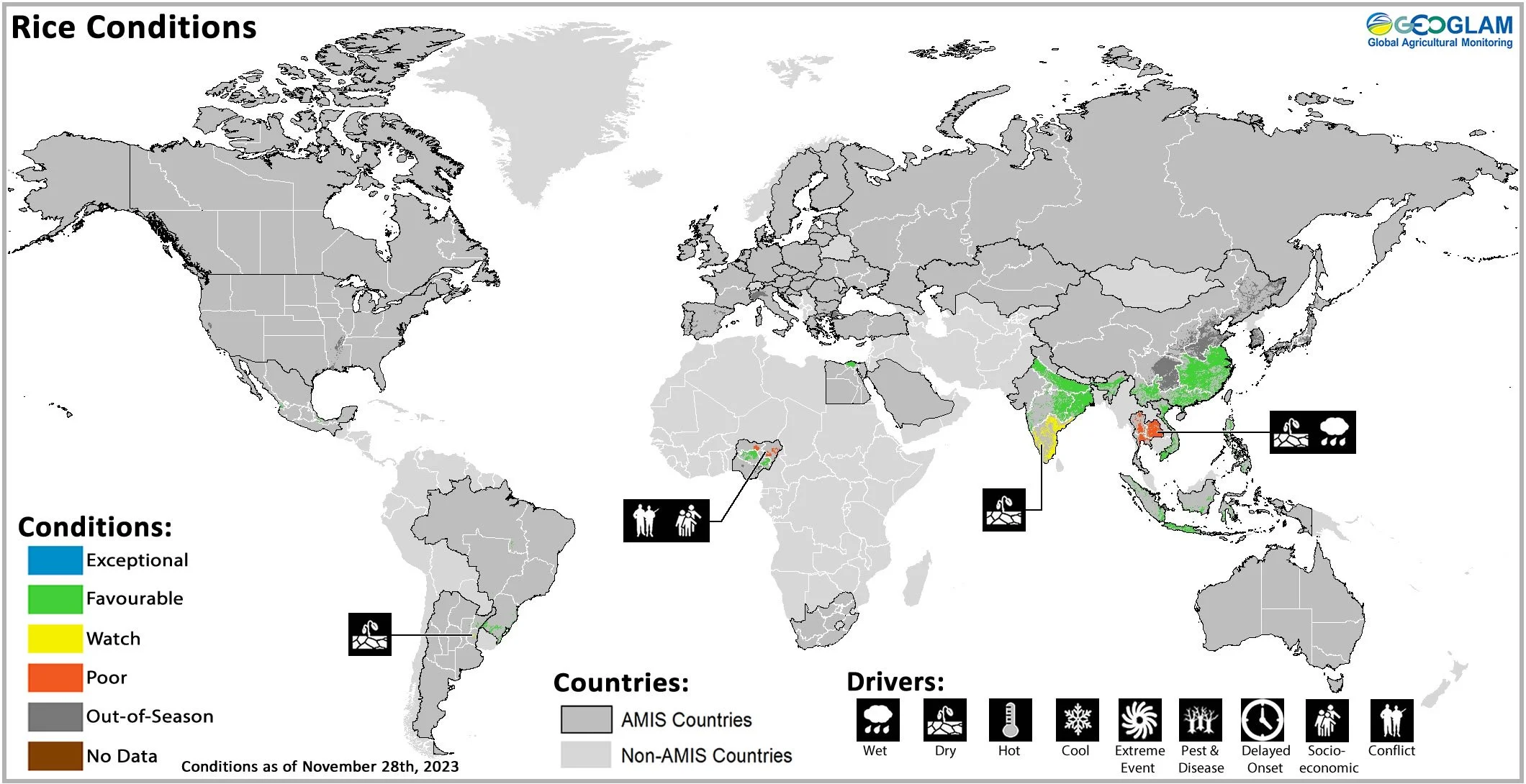
Rice crop conditions over main growing areas are based upon a combination of national and regional crop analyst inputs along with earth observation data. Crop condition information is based upon information as of November 28th. Where crops are in other than favourable conditions the climatic drivers responsible for those conditions are displayed. For detailed description of the pie chart please see box at the bottom of the page.
Rice: In China, harvesting is wrapping up for the late-season crop under favourable conditions. In India, harvesting of the Kharif season crop is wrapping up in the northern and central states, while ongoing in the southern and eastern states. In Indonesia, dry-season rice harvesting is wrapping up with good yields, but with a reduction of total harvested area. Wet-season rice sowing is continuing into its second month under favourable conditions. In northern Viet Nam, harvesting of the main wet-season rice is wrapping up under favourable conditions. In the south, harvesting of the other wet-season (autumn-winter and seasonal) rice is ongoing under favourable conditions as the sowing of dry-season rice begins. In Thailand, harvesting of wet-season rice is ongoing with poor yields due to early in-season drought followed by damages from floods. In the Philippines, wet-season rice sown in July to August is beginning to be harvested under favourable conditions with little damage reported from the passage of typhoon “Jenny”. In Brazil, sowing is progressing with an increase in the total sown area expected compared to last year.
Soybean Conditions

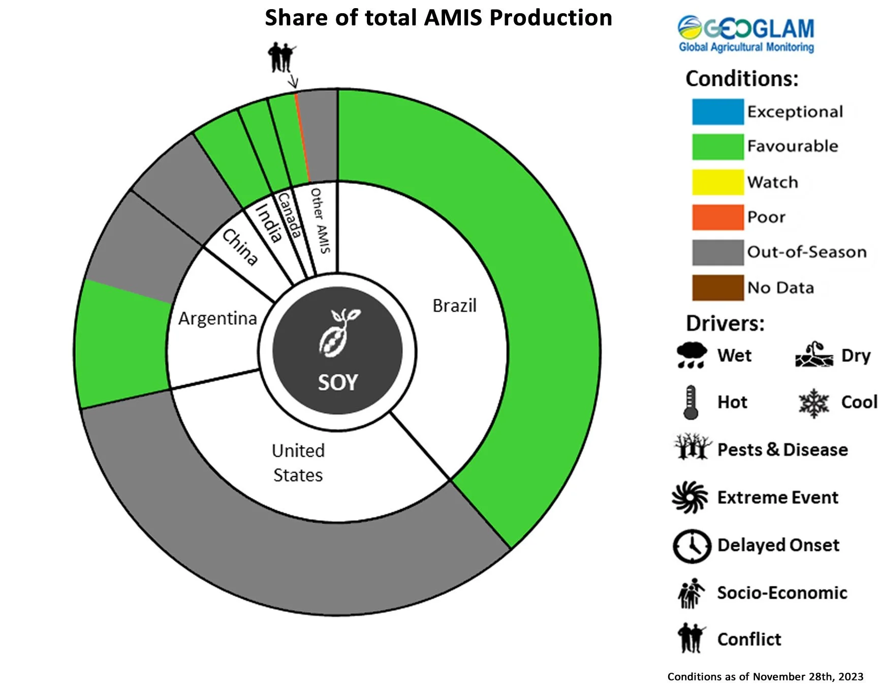
Soybean crop conditions over main growing areas are based upon a combination of national and regional crop analyst inputs along with earth observation data. Crop condition information is based upon information as of November 28th. Where crops are in other than favourable conditions the climatic drivers responsible for those conditions are displayed. For detailed description of the pie chart please see box at the bottom of the page.
Soybeans: In Canada, harvesting is wrapping up under favourable conditions with an anticipated increase in harvested area compared to last year. In India, harvesting is wrapping up under favourable conditions. In Ukraine, harvesting is wrapping up under favourable conditions away from the conflict zones. In Brazil, sowing is continuing under generally favourable conditions despite excess rainfall in the South region and a lack of rain in other producing regions. An increase in total sown area is expected compared to last year. In Argentina, after receiving some rainfall in recent weeks, sowing is accelerating across most growing areas. However, due to the earlier dry conditions and remaining drought in some places, a significant proportion of the early-planting crop (typically larger season) is being shifted to the late-planted crop (typically smaller season).
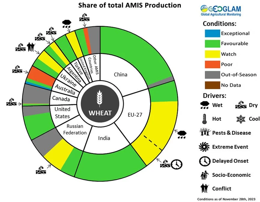
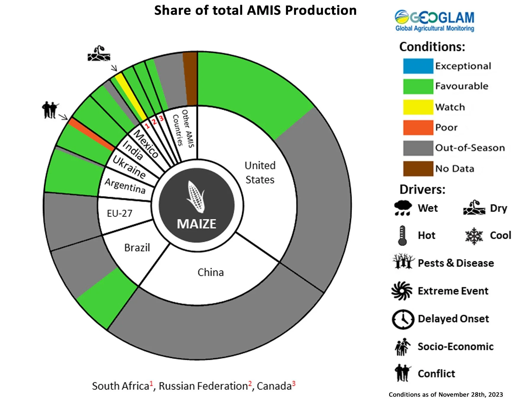
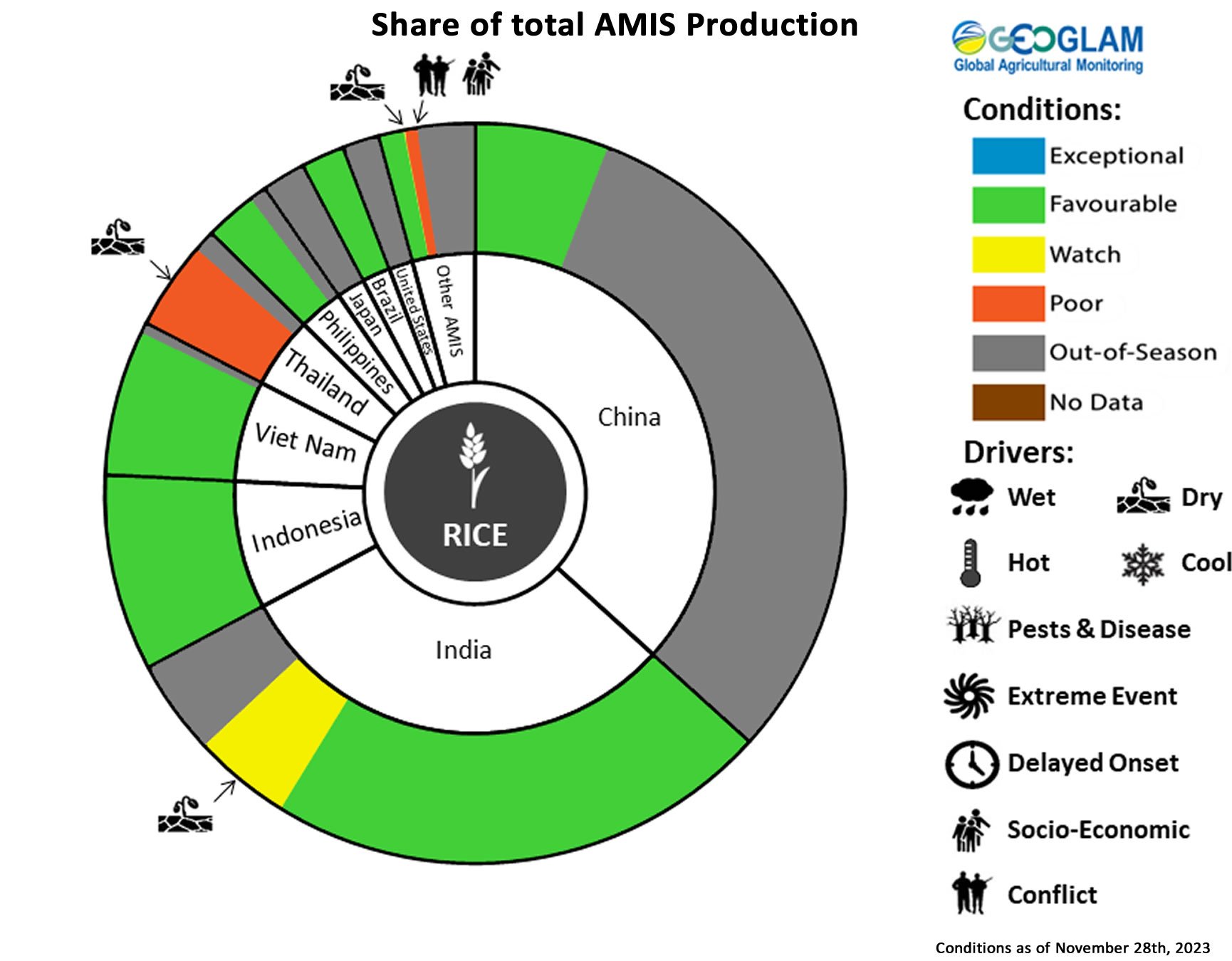
Pie chart description: Each slice represents a country's share of total AMIS production (5-year average). Main producing countries (representing 95 percent of production) are shown individually, with the remaining 5 percent grouped into the “Other AMIS Countries” category. The proportion within each national slice is coloured according to the crop conditions within a specific growing area; grey indicates that the respective area is out of season. Sections within each slide are weighted by the sub-national production statistics (5-year average) of the respective country. The section within each national slice also accounts for multiple cropping seasons (i.e., spring and winter wheat). When conditions are other than’ favourable’, icons are added that provide information on the key climatic drivers affecting conditions.
Information on crop conditions in non-AMIS countries can be found in the GEOGLAM Crop Monitor for Early Warning, published December 7th
Climate Influences: Strong El Niño Advisory and Intense Positive IOD
The ongoing El Niño is developing into a strong event and will likely maintain its strength into early 2024, possibly even becoming a historically strong event (35 percent chance). El Niño conditions will likely continue into March to May 2024 (88 percent chance) and transition to ENSO-neutral by May to July (55 percent chance), according to the North America forecast.
El Niño events tend to enhance precipitation in Central Asia, southern North America, south-eastern South America, east and southern East Africa, and south-eastern China. Drier-than-average conditions tend to occur in Central America, northern South America, parts of the northern U.S. and Canada, Southern Africa, Northern China, the Maritime Continent, and Australia.
The ongoing strong positive Indian Ocean Dipole (IOD) event will likely weaken in December but last into January, according to the Australian Bureau of Meteorology. The combination of positive IOD and El Niño conditions have led to intense rain and severe flooding in East Africa and dry conditions in Australia and the Maritime Continent.
Globally, temperatures during 2023 have been the warmest on record, and the warming influence of El Niño will likely continue this upward trend. Warmer temperatures will exacerbate rainfall deficits.
Source: UCSB Climate Hazards Center
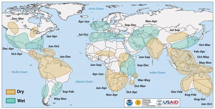
Location and timing of likely above- and below-average precipitation related to El Niño events. Based upon observed precipitation during 22 El Niño events since 1950, wet and dry correspond to a statistically significant increase in the frequency of precipitation in the upper and lower thirds of historical values, respectively. Statistical significance at the 95% level is based on the resampling of precipitation during neutral El Niño-Southern Oscillation conditions. Source: FEWS NET & NOAA & CHC
Global Two-week Forecast of Areas with Above or Below-Average Precipitation
The two-week forecast (Figure 1) indicates a likelihood of above-average rainfall over eastern Ontario and Quebec in Canada, the southeast US, southeast Mexico, southern Peru, southern Brazil, northern Uruguay, eastern Argentina, Gabon, southern Republic of the Congo, the Democratic Republic of the Congo, Uganda, Rwanda, Burundi, western Tanzania, northern Angola, northeastern Madagascar, northern Kazakhstan, central and eastern regions of the Russian Federation, western China, the Democratic Republic of Korea, the Republic of Korea, Myanmar, Viet Nam, Laos, southern Thailand, and the central Philippines.
There is also a likelihood of below-average rainfall over northern Canada, the western US, northwest Mexico, eastern Venezuela, southern and eastern Guyana, Suriname, southern French Guiana, northern and central Brazil, southern Chile, Czechia, southern Poland, southern and western Ukraine, Romania, Serbia, southern Russian Federation, Sierra Leone, southern Angola, Namibia, southern Zambia, northern Zimbabwe, central Mozambique, western South Africa, northeast Iran, eastern Turkmenistan, Uzbekistan, Afghanistan, Tajikistan, southern Kyrgyzstan, northern Pakistan, northwest India, Sir Lanka, northern Bangladesh, Indonesia, southern Papua New Guinea, and northern Australia.

Figure 1: IRI SubX Precipitation Biweekly Probability Forecast for 9 – 22 December 2023, issued on 1 December 2023. The forecast is based on statistically calibrated tercile category forecasts from three SubX models. Source: IRI Subseasonal Forecasts Maproom
Argentina Outlook
The 5 to 11 December precipitation anomaly forecast (left) indicates a likelihood of above-average rainfall over southern Santa Fe, Entre Rios, southern Cordoba, and northern Buenos Aires. During the same period, below-normal temperatures are expected over Santiago del Estero, southern Chaco, northern Cordoba, northern Santa Fe, Corrientes, and Entre Rios.
The 12 – 18 December precipitation anomaly forecast (centre) shows a likelihood of above-average rainfall over most agricultural areas except for southern Santa Fe, southern Entre Rios, eastern Cordona, and northern Buenos Aires. During the same period, above-average temperatures are likely over most agricultural areas except northern Santa Fe and Santiago del Estero.
The long-term December-January-February 2023/2024 precipitation anomaly forecast (right) indicates a likelihood of above-average rainfall over most agricultural areas with the highest likelihood over Entre Rios, Corrientes, and Misiones. During the same time, temperatures are likely to be near average across most of the main agricultural areas, with a likelihood of above-average temperatures in the north.

Left: 5 - 11 December 2023 forecast precipitation anomaly in mm. Centre: 12 – 18 December 2023 forecast precipitation anomaly in mm. Images from the National Meteorological Service of Argentina. Right: December-January-February 2023/2024 forecast rainfall anomaly. Image from the National Meteorological Service of Argentina.
Brazil Outlook
The December 2023 precipitation anomaly forecast (left) indicates a likelihood of below-average rainfall over northern and eastern Pará, Tocantins, northern Goiás, Maranhão, southern Piauí, Bahia, northern Minas Gerais, Espirito Santo, central Rio Grande do Sul, and central Mato Grosso. During this time, temperatures are likely to be above-average across all of Brazil, except for Rio Grande do Sul.
The long-term November-December-January 2023/2024 precipitation probability forecast (right) indicates a high likelihood of below-average rainfall across much of northern Brazil. Additionally, some areas in western Mato Grosso and central Rio Grande do Sul with a likelihood of below-average precipitation. The rest of Brazil is likely to see above-average precipitation. During this time, all of Brazil except for southern Rio Grande do Sul is likely to experience above-average temperatures.
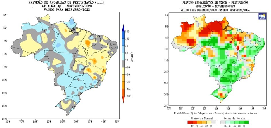
Left: December 2023 precipitation anomaly forecast, issued in November 2023. Right: November-December-January 2023/2024 precipitation probability forecast, issued in November 2023. Images from the National Institute of Meteorology