Crop Monitor for AMIS
Report Information
No. 137: Published April 2nd 2026
Conditions as of March 28th
To access all reports, please visit the Archive.
Please visit the Referencing Guidelines page for information on how to cite the Crop Monitor reports and products.
Overview
At the end of March, overall conditions are positive for wheat, maize, rice, and soybeans. In the northern hemisphere, winter wheat is emerging from dormancy and starting spring growth, while spring wheat sowing is beginning in some areas. For maize, harvesting is ongoing in South America and starting in India for the Rabi crop. Sowing has begun in China for spring maize and in the southeastern US. Rice conditions are favourable across Asia as sowing begins in China, and the harvest begins in India for the Rabi crop. For soybeans, conditions are generally favourable to exceptional in the Southern Hemisphere as harvest progresses in Brazil.
Global crop condition map synthesizing information for all four AMIS crops as of March 28th. Crop conditions over the main growing areas for wheat, maize, rice, and soybean are based on a combination of national and regional crop analyst inputs and earth observation data. Crops in conditions other than favourable are displayed on the map with their crop symbols.
Crop Conditions at a Glance
Wheat – In the northern hemisphere, winter wheat regrowth is beginning, with some areas of concern in parts of Europe and in North America.
Maize – Harvesting is ongoing in South America and starting in India for the Rabi crop. Sowing has begun in China for spring maize and in the southeastern US
Rice – Conditions are favourable across Asia as sowing begins in China and harvest begins in India for the Rabi crop.
Soybeans – In the southern hemisphere, harvesting progresses in Brazil as crops in Argentina and South Africa begin harvesting next month.
Forecasts at a Glance
Climate Influences – La Niña conditions were present during March 2026. Neutral ENSO conditions are expected during April and May, with El Niño likely to develop shortly after. According to the March 2026 NOAA CPC ENSO outlook, El Niño criteria will likely be met during June to August 2026, and the event will persist through the end of 2026.
India - The April outlook indicates likely above-average precipitation across most of the country, along with near-average maximum temperatures and above-average minimum temperatures.
United States– The April outlook indicates likely above-average precipitation over the Southern Great Plains, the Midwest, and the Northeast, while below-average precipitation over the West Coast and Southeast.
Wheat Conditions
Wheat crop conditions over the main growing areas are based on national and regional crop analyst inputs and earth observation data. Crop condition information is based on information as of March 28th. Where crops are in conditions other than favourable, the climatic drivers responsible for those conditions are displayed. Crop Season Specific Maps can be found in Appendix 2.
In the EU, winter wheat has resumed vegetative growth under mostly favourable conditions; however, there are concerns in Spain due to waterlogging and in the Baltic states and Poland due to below-average rainfall. In Türkiye, conditions are favourable for winter wheat. In Ukraine, winter wheat has resumed regrowth earlier than normal due to the warm weather in March. Low soil moisture levels in the south are a developing concern. In the Russian Federation, winter wheat has broken dormancy in the south and is under favourable conditions. In Kazakhstan, winter wheat is under favourable conditions. In China, winter wheat is out of dormancy, and spring wheat sowing is beginning. In India, the harvest is in the early stages under generally favourable conditions despite recent unseasonal rain and hail damage in several northern states. In the US, concerns persist for winter wheat due to persistent drought and exposure to earlier and recent cold weather. Spring wheat sowing is beginning in the Pacific Northwest, with an expected reduction in total sown area compared to last year. In Canada, winter wheat continues in mixed conditions as winter moisture remains insufficient across most areas.
For detailed description of the pie chart please see box at the bottom of the page.
Maize Conditions
Maize crop conditions over the main growing areas are based on national and regional crop analyst inputs and earth observation data. Crop condition information is based on information as of March 28th. Where crops are in conditions other than favourable, the climatic drivers responsible for those conditions are displayed. Crop Season Specific Maps can be found in Appendix 2.
Maize: In Brazil, the harvesting of the spring-planted crop (smaller season) is ongoing under favourable to exceptional conditions, especially in the South Region. Sowing of the summer-planted crop (larger season) is wrapping up with an increase in total sown area compared to last season. In Argentina, the harvest of early-planted crops (larger season) continues under mixed conditions due to variability in early rainfall. The late-planted crops (smaller season) are in the grain-filling stages under favourable conditions supported by recent rainfall. In Mexico, conditions are favourable for the autumn-winter season (smaller season). In South Africa, favourable to exceptional conditions continue across most provinces, supported by earlier, timely rains. In India, the harvest for the Rabi crop (smaller season) is ongoing under favourable conditions. In Indonesia, the sowing of the wet-season crop wraps up, as harvesting of earlier sown crops continues. In the US, earlier than normal sowing is beginning in parts of the southeast region. In China, sowing of spring-maize is beginning in the southwest.
For detailed description of the pie chart please see box at the bottom of the page.
Rice Conditions
Rice crop conditions over the main growing areas are based on national and regional crop analyst inputs and earth observation data. Crop condition information is based on information as of March 28th. Where crops are in conditions other than favourable, the climatic drivers responsible for those conditions are displayed. Crop Season Specific Maps can be found in Appendix 2.
Rice: In China, sowing has begun for early double-crop rice (smallest season). In India, the harvest is beginning for the Rabi crop as sowing wraps up for the Summer crop. In Bangladesh, the Boro crop (largest season) is under favorable conditions. Sowing of the Aus crop (smallest season) is beginning. In Indonesia, harvesting of wet-season rice continues with good yields due to sufficient water and sunlight during the growing period. In Vietnam, conditions are favorable as winter-spring (dry-season) rice harvest begins in the south, and sowing continues in the north. In Thailand, dry-season rice is in the grain-filling and harvesting stages, with yields expected to improve compared to last season. In the Philippines, dry-season rice conditions are favorable as crops sown in November and December are starting to be harvested. In Brazil, the harvest is progressing.
For detailed description of the pie chart please see box at the bottom of the page.
Soybean Conditions
Soybean crop conditions over the main growing areas are based on national and regional crop analyst inputs and earth observation data. Crop condition information is based on information as of March 28th. Where crops are in conditions other than favourable, the climatic drivers responsible for those conditions are displayed. Crop Season Specific Maps can be found in Appendix 2.
Soybeans: In Brazil, the harvest is proceeding slightly ahead of normal under favorable conditions. In the Central-West region, conditions are exceptional due to mostly good weather throughout this season. In Argentina, rainfall across much of the agricultural area has improved crop conditions for both the early-planting crop (larger season), which is nearing harvest, and the late-planted crop (smaller season), which is in a critical growth stage. In South Africa, conditions are favourable to exceptional, with good yields expected across most provinces.
For detailed description of the pie chart please see box at the bottom of the page.
Pie chart description: Each slice represents a country's share of total AMIS production (5-year average). Main producing countries (representing 95 percent of production) are shown individually, with the remaining 5 percent grouped into the “Other AMIS Countries” category. The proportion within each national slice is coloured according to the crop conditions within a specific growing area; grey indicates that the respective area is out of season. Sections within each slice are weighted by the sub-national production statistics (5-year average) of the respective country. The section within each national slice also accounts for multiple cropping seasons (i.e., spring and winter wheat). When conditions are other than’ favourable’, icons are added that provide information on the key climatic drivers affecting conditions.
Information on crop conditions in non-AMIS countries can be found in the GEOGLAM Crop Monitor for Early Warning.
Climate Influences: Waning La Niña and El Niño Watch
La Niña conditions were present during March 2026. Neutral ENSO conditions are expected during April and May, with El Niño likely to develop shortly after. According to the March 2026 NOAA CPC ENSO outlook, El Niño criteria will likely be met during June to August 2026 (62 percent chance), and the event will persist through the end of 2026 (83 percent chance for October to December 2026). While long-range forecasts made at this time of year can be unreliable, El Niño events can have widespread, global impacts, including a likely warming effect on global temperatures.
Abnormally hot temperatures occurred during March 2026 in portions of western and eastern Australia, El Salvador, western and central India, southern Madagascar, northwestern Mexico, South Africa, and the southwestern United States. During late March through mid-April 2026, above-average temperatures are forecast in South Africa, the eastern Sahel region, southern-central South America, across central, northern, and eastern Asia, western Australia, northern Mexico, and the United States. Below-average temperatures are forecast in northern Africa, central and eastern Canada, and the Middle East.
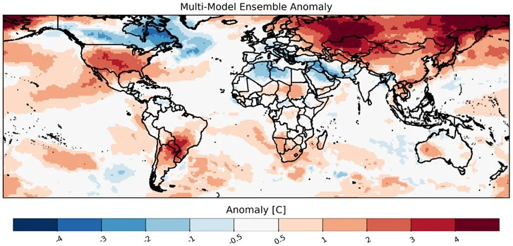
Maximum temperature forecast anomaly for the next 30 days starting on 26 February 2026, from three Subseasonal Consortium (SubC) models. SubC data accessed from the IRI Data Library. Map source: UCSB Climate Hazards Center
Global Two-week Precipitation Forecast
The two-week forecast (Figure 1) shows a chance of above-average precipitation over the southern and northern Midwest of the US, northeastern and southwestern Mexico, eastern Nicaragua, Costa Rica, eastern Panama, northern Colombia, Venezuela, northern Guyana, northern Suriname, northern French Guiana, southwestern Peru, northern Chile, northeastern Brazil, southern Italy, eastern Serbia, southwestern Romania, Bulgaria, North Macedonia, Greece, western and southern Türkiye, northern Syria, northern and western Iraq, northeastern and southwestern Iran, Qatar, the United Arab Emirates, eastern Oman, western Yemen, central Saudi Arabia, Jordan, northern and central Egypt, northern Libya, northern Algeria, Burkina Faso, northern Ghana, Togo, Benin, Nigeria, southern Chad, northern Cameroon, the northern Central African Republic, southern Sudan, northern South Sudan, northwestern Ethiopia, northwestern Angola, central South Africa, central Mozambique, northeastern Tanzania, southern Kazakhstan, Uzbekistan, western Kyrgyzstan, western Tajikistan, eastern Turkmenistan, Afghanistan, Pakistan, western and northcentral India, Nepal, Bangladesh, southern China, and the northeastern Russian Federation.
There is also a risk of below-average precipitation over northeastern Canada, the western US, central Bolivia, Paraguay, southern and southeastern Brazil, northern Argentina, central Chile, Ireland, the United Kingdom, northern Portugal, northwestern Spain, France, Switzerland, Belgium, the Netherlands, western Germany, Denmark, southern Norway, central Sweden, Finland, Estonia, Latvia, northern Belarus, the northwestern Russian Federation, northwestern Romania, eastern Hungary, Slovakia, northcentral Saudi Arabia, southern Ethiopia, southern Somalia, Kenya, Uganda, southern South Sudan, Rwanda, Burundi, northern Tanzania, northern Madagascar, northern Mongolia, northwestern and northeastern China, the Democratic People's Republic of Korea, southern and northern Japan, the Philippines, southern Viet Nam, Cambodia, Thailand, eastern Myanmar, Malaysia, northern and eastern Indonesia, Papua New Guinea, and northern and eastern Australia.
Figure 1: IRI SubX Precipitation Biweekly Probability Forecast for 4 – 17 April, issued on 27 March 2026. The forecast is based on statistically calibrated tercile category forecasts from three SubX models. Source: IRI Subseasonal Forecasts Maproom
India Outlook
The April 2026 outlook indicates likely above-average precipitation over the country, with average to above-average precipitation over most parts of the country except the Northeast and Northwest. During this time, the maximum temperatures for April are likely to be near average across most of the country, with areas of likely above-average maximum temperatures over the Northeast, Northwest, and parts of the central regions. With the highest likelihood over Jharkhand, northern Chhattisgarh, and northern Odisha. Minimum temperatures for April are likely to be above-average across most of the country except for over Telangana and northern Andhra Pradesh. The likely above-average temperatures, along with likely below-average precipitation during April, will most likely maintain or worsen the drought situation in the Northeast and Northwest regions. Conversely, the above-average rainfall over the northern and central regions may hinder Rabi crop harvesting.
Top: April 2026 precipitation anomaly forecast. Bottom Left: April 2026 maximum temperature probability forecast. Bottom Right: April 2026 minimum temperature probability forecast. Maps from the India Meteorological Department
United States Outlook
The April 2026 precipitation forecast indicates likely above-average precipitation over the Southern Great Plains north-eastward over the Middle and Upper Mississippi Valley and the eastern portions of the Central and Northern Great Plains, Great Lakes region, Northeast, Ohio Valley, and Upper Mid-Atlantic region, while below-average over the south-central Rockies, portions of the central High Plains region, and the southeast over northern Florida, Georgia, and South Carolina. During the same time, temperatures are likely to be above average over most of the country except for the northern states.
The impacts of April’s forecasted weather are the likely continuation of drought over the western US and the Southeast, while drought is likely to expand over parts of Arizona, Nevada, Colorado, and western Kansas. At the same time, drought conditions are likely to improve or be removed across parts of Texas, Oklahoma, Louisiana, Arkansas, Iowa, Illinois, Indian, Ohio, Minnesota, and Pennsylvania.
Upper Left: April 2026 precipitation outlook issued on 31 March 2026. Upper Right: April 2026 temperature outlook issued on 31 March 2026. Bottom: April 2026 drought outlook released on 31 March 2026. Maps from NOAA CPC and NOAA/National Weather Service, National Centers for Environmental Prediction, and Climate Prediction Center..