
Crop Monitor for Early Warning
Report Information
No. 120: Published October 1st 2026
Conditions as of September 28th
For access to all reports, please visit the Archive.
Please visit the Referencing Guidelines page for information on how to cite the Crop Monitor reports and products.
Overview
In East Africa, prolonged rainfall deficits since around April and high temperatures resulted in below average yields in many areas, including main producing regions in Ethiopia and western Kenya.
In West Africa, agro-climatic conditions remain mostly favourable for ongoing cropping activities with some localized areas of dry conditions rainfall deficits along parts of the Sahel.
In the Middle East & North Africa, rice prospects remain favourable in Egypt, Iraq, and Iran, and land preparation is beginning for the upcoming 2026/27 wheat season.
In Southern Africa, winter wheat prospects have degraded in the main producing region of South Africa due to recent dry impacts. Elsewhere, in Zimbabwe and Zambia wheat prospects remain favourable.
In Central & South Asia, the 2025/26 spring wheat harvest is underway with generally favourable conditions with some areas of dryness.
In Southeast Asia, conditions are generally favourable for dry-season rice and maize in the south, while drought is negatively impacting wet-season crops in Thailand and Cambodia, and heavy rains are negatively impacting parts of the Philippines, Vietnam and Myanmar.
In Central America & the Caribbean, harvesting of Primera season crops is complete, and below average yields resulted across the region due to prolonged dry spells and high temperatures since the start of the season.
Crop Conditions at a Glance
Crop condition map synthesizing information for all Crop Monitor for Early Warning crops as of September 28th. Crop conditions over the main growing areas are based on a combination of inputs including remotely sensed data, ground observations, field reports, national, and regional experts. Regions that are in other than favourable conditions are labeled on the map with a symbol representing the crop(s) affected.
EAST AFRICA: Harvesting of main season cereals is complete or nearing completion in the south, while main season crops are in vegetative to reproductive stage in the north. Record dry conditions and high temperatures are expected to negatively impact yields in Sudan, South Sudan, Ethiopia (Meher season), Somalia, Kenya, northern Uganda, Burundi and Rwanda (See Regional Alert Pg. 7). Conversely, the October to December rainfall season is expected to be above average (See Seasonal Forecast Alert Pg. 8).
WEST AFRICA: Harvesting of main season cereals is complete along the south while crop development continues along the Sahel. Overall cropping prospects remain mostly favourable in non-conflict affected areas, however, there are some concerns due to localized rainfall deficits in parts of the Sahel.
MIDDLE EAST & NORTH AFRICA: Land preparation for the 2026/27 wheat season is underway, and planting will mostly commence in October. Rice prospects remain favourable in Egypt, Iraq, and Iran.
SOUTHERN AFRICA: Land preparation for the 2026/27 main season is underway, and planting will mostly commence in October. Below-normal rainfall is expected for the start of the season from October 2026 to January 2027 due to the strengthening El Niño (See Seasonal Forecast Alert Pg. 11). Wheat continues to develop under mixed conditions due to developing dry impacts in the main producing region of South Africa.
CENTRAL & SOUTH ASIA: Spring wheat harvesting is underway and overall prospects remain favourable however there are some areas of concern in Kazakhstan, Tajikistan and Kyrgyzstan due to recent dry conditions.
SOUTHEAST ASIA: In the south, conditions are generally favourable for dry-season rice and maize harvesting. In the north, conditions are mixed for wet-season rice and maize development as drought may negatively impact outputs in Thailand and Cambodia, while recent heavy rains impacted crops in parts of the Philippines, Myanmar and Vietnam.
CENTRAL AMERICA & CARIBBEAN: Harvesting of Primera season cereals is complete and extended dry spells and high temperatures this season negatively impacted yields for both large and small-scale farmers, particularly for maize crops in Honduras and Nicaragua. Dry conditions have continued through the start of the Segunda/Postrera season in September and October to December rainfall is forecast to be below normal corresponding with the forecast strong El Niño (See Regional Outlook Pg. 18).
Global Climate Outlook: Two-week forecast of areas of above or below-average precipitation
The two-week forecast (Figure 1) shows a chance of above-average precipitation over the southwest US, northwest and central Mexico, southern Guatemala, southwest Honduras, western Ecuador, south and southeast Brazil, eastern Paraguay, central Chile, central west Argentina, Greece, eastern Türkiye, Georgia, Armenia, Syria, central and northwestern Iraq, northeastern and eastern Iran, eastern Egypt, northern Libya, southern Tunisia, central and northeastern Algeria, northern and southern Mauritania, southern and central Mali, Senegal, The Gambia, Guinea-Bissau, Guinea, northern Côte d'Ivoire, Burkina Faso, southwestern Niger, eastern Ethiopia, Somalia, eastern Kenya, northeastern Tanzania, southern Angola, Namibia, western Botswana, Kyrgyzstan, Tajikistan, northeastern Afghanistan, northern Pakistan, eastern Myanmar, northern Laos, northern and eastern Thailand, northern Viet Nam, north China, and the northern Philippines.
There is also a risk of below-average precipitation over northwestern and northern Canada, the central Mississippi Valley in the US, northern Honduras, Haiti, the Dominican Republic, central and northern Colombia, eastern Ecuador, central Peru, Venezuela, Guyana, Suriname, French Guiana, northern Brazil, northern and southern Bolivia, northern Argentina, southern Chile, the United Kingdom, northwestern Spain, northern France, Belgium, the Netherlands, northwestern Germany, Denmark, southern Norway, southern Sweden, Poland, Lithuania, Latvia, Estonia, Belarus, Ukraine, the western Russian Federation, Moldova, northeastern Romania, north central Türkiye, southern Yemen, northern and western Ethiopia, southern Sudan, South Sudan, the eastern Central African Republic, western Gabon, the southern Republic of the Congo, the western and southern Democratic Republic of the Congo, Uganda, western Kenya, Rwanda, Burundi, northern and western Tanzania, northeastern Zambia, northern Malawi, northern Madagascar, eastern South Africa, Eswatini, western Kazakhstan, central and eastern India, Nepal, Bhutan, Bangladesh, northern Sri Lanka, northeastern and southwestern China, northern Japan, northern Myanmar, southern Thailand, central Malaysia, Indonesia, Papua New Guinea, northern and central Australia, and northern New Zealand.
Figure 1: IRI SubX Precipitation Biweekly Probability Forecast for 3 – 16 October 2026, issued on 25 September 2026. The forecast is based on statistically calibrated tercile category forecasts from three SubX models. Source: IRI Subseasonal Forecasts Maproom
Climate Influences: El Niño Present and forecast to develop into a very strong event by September 2026 to January 2027
El Niño conditions are present and strengthening. The event will likely be very strong from September 2026 to January 2027 (> 90% chance, according to the September 2026 NOAA ENSO outlook) and rank as one of the strongest since 1950. El Niño conditions are forecast through April 2027 (80% chance).
El Niño events tend to enhance rainfall in parts of Asia (in Central Asia, southwestern Asia, and eastern China), southern North America, southeastern South America, southern Europe, eastern and southern East Africa. Drier-than-average conditions tend to occur across Central America, the Caribbean, northern South America, Southern Africa, the Maritime Continent, and Australia.
Positive Indian Ocean Dipole (IOD) conditions are forecast during October to December 2026. Positive weekly IOD values from the Bureau of Meteorology indicate the event is developing. A positive IOD tends to enhance the drying influence of El Niño in Australia and the Maritime Continent and substantially increase the chances of a wet and intense East Africa short rains season.
August 2026 was one of the warmest months ever recorded for global temperatures, according to the Copernicus Climate Change Service Climate Bulletin. The very strong El Niño will continue to increase the likelihood of extreme conditions.
During late September through early October 2026, abnormally hot temperatures are forecast in active crop development areas of the southeastern United States, eastern Mexico, Central America, Haiti, central Brazil, East Africa, southwestern Iran, southern and northern Pakistan, southern and northern India, Bangladesh, Myanmar, southern Indonesia, and the Philippines (Figure 1)
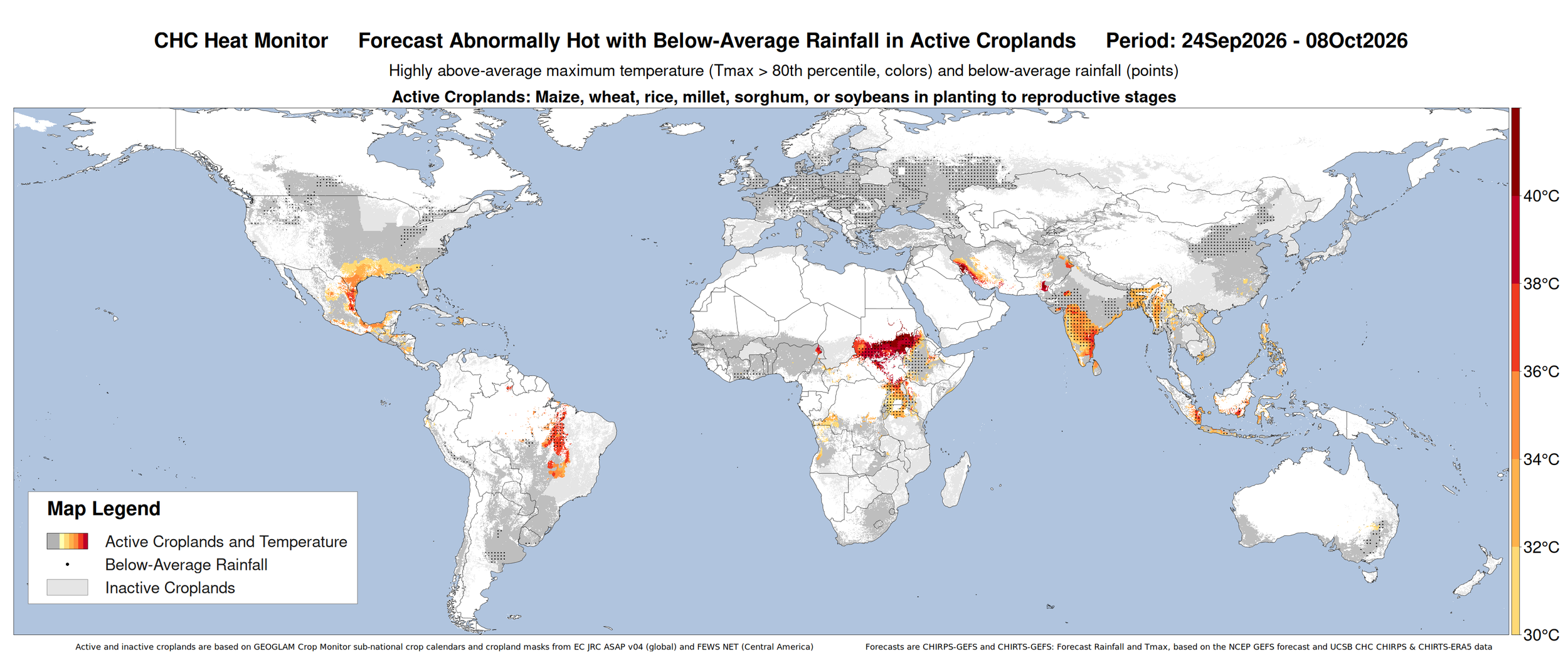
Figure 1: CHC AgriHeat Forecast for September 24 to October 8, 2026. Forecast 15-day average maximum temperatures are shown where these will be abnormally hot (Tmax > 80th percentile and > 30 °C) and in active crop growing areas. Areas with forecasted below-average rainfall for this period are also identified. Based on the 15-day CHIRTS-GEFS and CHIRPS-GEFS forecasts from August 27, 2026. From UCSB Climate Hazards Center.
East Africa
Crop condition map synthesizing Maize 1 crop conditions as of September 28th. Crop conditions over the main growing areas are based on a combination of inputs including remotely sensed data, ground observations, field reports, national, and regional experts. Conditions that are other than favourable are labeled on the map with their driver.
Across northern East Africa, harvesting of first season cereals finalized in bimodal regions of southern South Sudan, while main season cereals are mostly in the vegetative to reproductive stage across Sudan, unimodal regions of South Sudan, Eritrea, Ethiopia (Meher season), and Yemen. Conditions have been downgraded to poor across Sudan, South Sudan, and much of Ethiopia due to delayed and generally inadequate rainfall outcomes for the June to September season as well as ongoing conflict in Sudan and hotter than normal conditions in South Sudan. The June to September 2026 rainfall season was exceptionally poor in northern and western East Africa and ranked as the driest on record across large areas of South Sudan, southern Sudan, northern and eastern Uganda, western and northwestern Kenya, and parts of southwestern, western, northern and central Ethiopia (See Regional Alert Pg. 7). Additionally, dry concerns remain across Eritrea and conditions have been downgraded to poor in Yemen due to ongoing dryness. Antecedent dry and hot conditions are also impacting the start of second season planting in bimodal regions of southern South Sudan.
Across southern East Africa, harvesting of main season cereals is complete in bimodal regions of Uganda, Kenya, Somalia (Gu season), and United Republic of Tanzania while harvesting of main season cereals is just beginning in unimodal regions of northern Uganda and unimodal regions in the western half of Kenya. Failure outcomes resulted in southern Somalia due to persistent dry and hot seasonal conditions. Additionally, persistent deficits since around April and high temperatures are expected to result in poor yield outcomes elsewhere in Somalia as well as in Karamoja region in northeastern Uganda and throughout Kenya. Planting of second season maize is just beginning in bimodal regions of Uganda,Tanzania, Burundi and Rwanda with some concern due to dry conditions. However, above-normal October to December (OND) 2026 rainfall is forecast in Ethiopia, Somalia, Kenya, Uganda, central and southern South Sudan, Rwanda, Burundi, and Tanzania due to the effects of El Niño and positive IOD and this also raises the risks of heavy and damaging rainfall events and flooding especially in the eastern Horn of Africa (See Seasonal Forecast Alert Pg. 8).
Crop condition map synthesizing Maize 2 conditions as of September 28th. Crop conditions over the main growing areas are based on a combination of inputs including remotely sensed data, ground observations, field reports, national, and regional experts. Conditions that are other than favourable are labeled on the map with their driver.
Northern East Africa & Yemen
In Sudan, crops are in the vegetative to reproductive stage, and conditions have been downgraded to poor due to delayed onset below-average rainfall outcomes for the June to September season. While irrigation is typically used along the Nile, the area under production is limited this year, and production expectations are well below the previous year. Additionally, ongoing conflict continues to disrupt agricultural activities throughout the country. In South Sudan, planting of second season maize and sorghum crops is just beginning in bimodal regions with concern due to antecedent dry conditions. As of July, new conflict was reported between the government and opposition forces across the Upper Nile and Jonglei states, which is likely to limit land access and reduce the planted area. In Eritrea, crops are in the vegetative to reproductive stage and delayed and below-average rains continue to impact cropping activities, particularly in the centre and west. In Ethiopia, Meher season cereals are in the vegetative to reproductive stage, and conditions have been downgraded to poor due to rainfall delays and deficits for the June to September Kiremt season, including in the main producing highlands region. Severe rainfall deficits have resulted in drought conditions across northern, eastern, and central regions of the country. Conversely, in the west, recent rainfall has improved cropping conditions however, concern remains. The ongoing El Niño event is expected to continue dry conditions during the remainder of the June to September Kiremt rainfall season, which accounts for more than 70 percent of national crop production. This will likely be followed by heavy rains and increased flooding risk between October and December. Historically, El Niño events have suppressed Kiremt rains in the centre, north, northeast, and east, while increasing the likelihood of heavy rains and flooding in southern and southeastern lowland areas later in the year (See Climate Influences Pg 4, Regional Alert Pg. 7, and Seasonal Forecast Alert Pg. 8). In Yemen, harvest has completed for wheat crops while sorghum harvest is underway. Dry conditions continue to negatively impact crop development and are expected to continue through October (See Regional Alert Pg. 7).
Crop condition map synthesizing Sorghum 1 conditions as of September 28th. Crop conditions over the main growing areas are based on a combination of inputs including remotely sensed data, ground observations, field reports, national, and regional experts. Conditions that are other than favourable are labeled on the map with their driver.
Southern East Africa
n Somalia, land preparation is underway for the upcoming Deyr season. Heavy El Niño-induced rains are expected between October and December, increasing the risk of widespread flooding for the start of the Deyr season (See Climate Influences Pg. 4 and Regional Alert Pg. 8). According to recent extended outlook estimates, with an intensifying El Niño and a likely positive Indian Ocean Dipole, substantial rainfall is likely to support above-normal maize and sorghum production overall but also raise the chances of negative impacts, especially along the Juba and Shabelle Rivers. In Kenya, harvesting is underway in the unimodal and major producing western half of the country. Erratic rains and prolonged deficits since April as well as high temperatures are expected to result in poor yield outcomes across most areas, particularly in the major producing western half of the country. According to recent maize yield forecast estimates produced under the Kenya ADAPT project in partnership with the Ministry of Agriculture in Kenya, maize yields are forecast to be up to 36 percent below average in some major producing counties in the west, based on the GEOCIF crop yield forecast model. The October to December short rains season is expected to be above-average and generally well distributed (See Seasonal Forecast Alert Pg. 8). The short rains season is particularly important in the bimodal eastern and southeastern areas, where it contributes more than 40 percent of annual rainfall. However, above average and heavy rains could also result in flooding in areas. In Uganda, harvesting of first season cereals complete in bimodal regions of the centre and south, while harvesting is ongoing in the north. Despite drier than normal conditions this season, bimodal regions have been upgraded to favourable. These areas typically receive high rainfall, so even reduced totals were adequate for crop development, though production may still be lower than usual. Conversely, in Karamoja region located in the northeast along with areas in the northwest poorly distributed and below-average rains from April to July below average yields. In Burundi, harvesting of Season B rice crops is complete with favourable yields expected while planting is underway for Season A maize crops and there is some concern due to antecedent dry conditions. In bimodal regions of the north and northeast of the United Republic of Tanzania, harvesting of Masika season cereals finalized in August under favourable conditions despite minor deficits in parts of the west.
For detailed description of the pie chart please see description box on the bottom of the page.
Regional Alert: Extreme dry June to September 2026 rainfall season
The June to September 2026 rainfall season was exceptionally poor in northern and western East Africa. An outlook for June 1st to September 30th, 2026, shows drier-than-average conditions prevailed across Sudan, South Sudan, Uganda, western Kenya, northwestern Somalia, and western, central, and northern Ethiopia with seasonal totals expected to be less than 30 to 75 percent of average (Figure 1 middle-left). The season was exceptionally dry, ranking as the driest on record across large areas of South Sudan, southern Sudan, northern and eastern Uganda, western and northwestern Kenya, and parts of southwestern, western, northern and central Ethiopia (Figure 1 middle-right).
Below-average conditions persisted into late August to mid-September across much of the region, limiting opportunities for recovery from earlier seasonal deficits. However, recent above-average rainfall brought localized improvements to moisture conditions in parts of central Ethiopia (Figure 1-left).
El Niño-driven severe dry conditions reduced pasture and surface water availability and are likely to result in below-average crop yields in many locations across the region. Poor rainfall and prolonged dry spells reduced moisture available to crops during key phenological stages, with seasonal rainfall deficits of 100 to more than 300 mm observed across northeastern Uganda, western and North Rift Kenya, Kiremt-receiving areas of central, eastern, and northern Ethiopia, parts of northern, central and eastern South Sudan, and southeastern Sudan. Record high maximum temperatures during JJAS 2026 were also observed in the rainfall deficit areas (Figure 1-right) compounding seasonal moisture stress. More recently well-above-normal temperatures, with anomalies exceeding 3 °C, further exacerbated dry conditions in southeastern Sudan, including in key crop growing areas of Sennar, Blue Nile, and Gedaref states, as well as parts of central and northern South Sudan, including Unity, Warrap, and Bahr el Ghazal.


Hotter-and drier-than-normal conditions are forecast to continue through September across southern Sudan and parts of northern South Sudan, where crops are in reproductive to maturation stages. The poor 2026 growing season is particularly concerning given the already severe food insecurity in Sudan and South Sudan. Below-average crop production could further constrain food availability and livelihoods, worsening food insecurity in affected areas.

Figure 1. Left, middle-left and middle-right panels are CHC Early Estimates, which compare the August 21st to September 20th, 2026 (Left), June 1st to September 30th, 2026 (Middle-left) and June 1st to September 30th (Middle-right) precipitation totals to the 1996–2025 CHIRPS averages for the same accumulation period. These panels use CHIRPS3 Preliminary for September 1–20, 2026. A bias-adjusted NCEP GEFS forecast (CHIRPS3-GEFS) is used for the 15-day forecast from September 21st. Right: Average daily maximum temperatures for June 1st to September 18th, 2026.
Source: UCSB Climate Hazards Center
Seasonal Forecast Alert: Forecast above-average rains and flood concerns in the eastern Horn during October to December 2026
Above-normal October to December (OND) 2026 rainfall is forecast in Ethiopia, Somalia, Kenya, Uganda, central and southern South Sudan, Rwanda, Burundi, and Tanzania. IGAD Climate Prediction and Applications Centre (ICPAC), National Meteorological and Hydrological Services, NMME, C3S, CHC, and WMO multi-model ensemble show agreement.
El Niño and positive IOD tend to enhance OND rains, raising the risks of heavy and damaging rainfall events especially in the eastern Horn of Africa. A very strong El Niño is expected to persist during September 2026 to January 2027. Models also predict positive Indian Ocean Dipole (IOD) conditions during OND 2026, driven by very warm sea surface temperatures in the western Indian Ocean. The IOD has been neutral, and positive weekly IOD values from the Bureau of Meteorology since mid-September indicate the forecast positive IOD is developing.
The September forecast for OND 2026 El Niño and the Indian Ocean Dipole strength is compared to observed values of past years in Figure 2 (left). It highlights seven years that are within range of the 2026 forecast and the frequency of highly above-average OND rainfall during those years (middle-left). The ECMWF probabilistic forecast for OND 2026 rainfall tercile, from early September, confidently predicts 70 to 90 percent chances of above-normal OND 2026 rainfall in these areas (middle-right).
The forecast rains are expected to support pasture regeneration and replenishment of surface waters across pastoral areas. Heavy and persistent rains also increase flood risks in riverine, urban, and flash-flood prone areas, as well as risks of landslides, displacement, disease outbreaks, and transportation disruptions. Associated with past rainfall outcomes and seasonal rainfall forecasts (Figure 2 middle), areas of highly elevated risks of flash flooding or riverine floods include southern Somalia and the Juba River and Shabelle River areas and northeastern and southeastern Kenya and the Tana River basin. Due to the potential for impacts like the 2023 and 1997 El Ninos, the Intergovernmental Authority on Development (IGAD) broadcast a High-Level Call to Action to steepen preparations to protect people and resources.
Above-average rains will likely begin during late September to mid-October in the eastern Horn, according to the SubC subseasonal forecasts from September 23rd (right) and the ECMWF. Drier-than-average conditions in western and northern areas may continue into early October. The ECMWF forecast from September 22nd indicates wetter conditions expanding into central and western Kenya, western Ethiopia, Uganda, Rwanda and Burundi in mid to late October.
The extremely low rainfall in South Sudan during June to September 2026 led to a decline in national flooded extent between August and September. National flood extent is forecast to decrease through October, with a small rebound in November, based on a FEWS NET outlook. Uganda’s Ministry of Water and Environment warned that if above-average seasonal rains occur in the Lake Victoria basin, the resulting higher Nile River flow will raise downstream flood risks including for the Sudd wetland region. Outcomes will depend on the extremity of rains and water management. The forecast odds of a wetter-than-normal OND 2026 in western areas, including Lake Victoria basin, are 1.5 to 2 times greater than normal, based on the September ECMWF forecasts. These are lower than comparable forecasts before the high-impact OND 2019 season, likely due to the late development of the IOD in 2026. Close monitoring of rainfall conditions is recommended throughout the OND 2026 season.
Figure 2. October to December 2026: Forecast El Niño and positive Indian Ocean Dipole, historical frequency of highly above-average rainfall, and 3-month and 30-day rainfall forecasts. Left: The current ENSO/Relative ONI (RONI) and Indian Ocean Dipole (IOD) forecast for OND 2026, compared to historical observations (scatterplot), and historical rainfall tercile outcomes (filled colors) in eastern East Africa (EEA; 8.5N-4.5S, 38E-50E). The September NMME and ECMWF mean OND 2026 forecasts for RONI and IOD are shown with a range of values within a 95% confidence interval (large and small red triangles, respectively), post forecast bias-correction using historical 1991–2025 forecasts. The most relevant (to this forecast) historical years are identified, based on these intervals for RONI and IOD (black outlines). Left-Middle: Using the seven years identified by the OND 2026 RONI and IOD forecasts (left), this map shows the frequency of observed OND rainfall in highly above-average or below-average categories (> 80th percentile and < 20th percentile, respectively), based on CHIRPS v3 data. Middle-right: ECMWF SEAS5 probability forecast for OND 2026 rainfall tercile, September initial conditions, from NOAA PSL C3S Monthly to Seasonal Forecasts. Right: SubC multi-model 30-day rainfall tercile probability forecast for Sep. 23 to Oct. 22, 2026. Colors show the dominant category forecast by five Subseasonal Consortium models, using terciles identified from 1999-2016 hindcasts. From UCSB CHC SubC. SubC data acquired from the IRI Data Library.
Source: UCSB Climate Hazards Center
West Africa
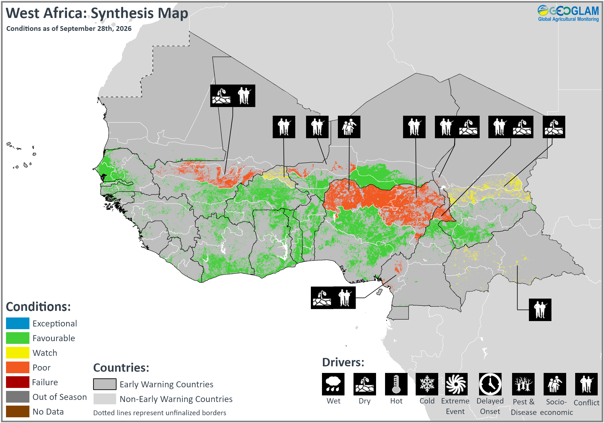
Crop condition map synthesizing crop conditions as of September 28th. Crop conditions over the main growing areas are based on a combination of inputs including remotely sensed data, ground observations, field reports, national, and regional experts. Crops that are in other than favourable conditions are labeled on the map with their driver.
In southern West Africa, harvesting of main season cereals is complete or nearing completion in Sierra Leone, Liberia, Côte d’Ivoire, Ghana, Togo, Benin, Nigeria, and Cameroon, while planting and development continue in Guinea and the Central African Republic. Planting and development of the second season cereals continue in Côte d’Ivoire, Ghana, Togo, Benin, and Nigeria. Along the Sahel, harvesting of main season cereals is underway in Senegal, Guinea-Bissau, Mali, Burkina Faso, Niger, and Chad, while crops continue to develop in Mauritania and Gambia. Agro-climatic conditions remain generally favourable for ongoing cropping activities despite localized deficits in parts of the Sahel resulting in below-average vegetation conditions and reduced water availability for crops. However, short-term forecasts of above-normal precipitation toward the end of September and early October could provide brief relief in affected areas, though a full recovery is not expected.
In southern and eastern Chad, conditions have improved from earlier deficits and are under favourable conditions. In bimodal areas along the Gulf of Guinea, average to above-average production is expected for the main season harvest following adequate rainfall outcomes this season. Additionally, ongoing conflict continues to adversely affect agricultural outcomes in central Mali, northern Burkina Faso, western Niger, the Lac region in Chad, northeastern Nigeria, northern and southwestern Cameroon, and the Central African Republic, and socio-economic issues relating to inter-communal conflict continue to impact northwestern Nigeria. In Burkina Faso, localized late and irregular rainfall at the beginning of the season and longer dry spells forecast between August and October could negatively impact yields and production. In Niger, delayed, erratic, and below-average rainfall resulted in lower-than-normal seeding coverage in localized areas with varying stages of crop development. However, regular rains received since the beginning of August have improved growing conditions. In Chad, several regions experienced a delayed start to the season with below-average rainfall. However, recent rainfall improvements have supported crop development. In the Central African Republic, planted areas are close to average in the main producing central and southern regions. While below-average rains received in the Vakaga region in the north could reduce yields, forecast above-average rainfall between August and October across most of the country is expected to support production prospects. However, insecurity and limited land access continue to constrain production outcomes, and a fuel shortage in July resulted in a sharp increase in fuel prices and compounded already high transportation costs.
Middle East & North Africa
Across the Middle East and North Africa, winter wheat harvesting finalized in July with generally favourable yields expected, as a dry start to the season was followed by rainfall improvements from late 2025, except in northwestern Libya and southern Iraq, where yields were likely impacted by seasonal dryness and irrigation restrictions, respectively. Throughout the subregion, wheat cropping is now out of season, and planting will mostly begin in October for the 2026/27 season.
In Egypt, summer-planted rice and maize crops are in the vegetative to reproductive stage while planting of Nili season (Nile flood) rice continues, and overall cropping prospects remain favourable. Rice harvesting has finalized in Iran under favourable conditions while harvesting in underway in Iraq, where production has been permitted for this year, and conditions remain favourable.
Southern Africa
Crop condition map synthesizing wheat conditions as of September 28th. Crop conditions over the main growing areas are based on a combination of inputs including remotely sensed data, ground observations, field reports, national, and regional experts. Crops that are in other than favourable conditions are labeled on the map with their driver.
Across Southern Africa, land preparation is underway for the 2026/27 main season, and planting will begin across Angola, Zambia, South Africa, Lesotho, and eSwatini in October. Current models indicate moderately high chances of below-normal rainfall across much of the region from October 2026 to January 2027, in association with the ongoing strong El Niño (See Climate Influences Pg.4 and Seasonal Forecast Alert Pg. 11). According to recent extended outlook estimates, for the 2026/2027 maize harvest, the developing El Niño event makes poor yield outcomes likely in Zimbabwe and South Africa. Regional total production of maize and sorghum during past El Niño events has been about 10 to 15 percent below normal, and deficits of over 40 percent are possible.
Below-normal October to December 2026 rainfall is forecast across southern Angola, southern Zambia, Zimbabwe, southern Malawi, central and southern Mozambique, Namibia, Botswana, and most of South Africa. Many of these areas are forecast to remain drier-than-normal through March 2027 (Seasonal Forecast Alert Pg. 11). Conversely, normal to above-normal October 2026 to March 2027 rains are forecast over most of the DRC, northwestern Angola, northern Zambia, northern Malawi, and northern Mozambique (See Seasonal Forecast Alert Pg. 11).
In the Democratic Republic of the Congo, harvesting of second season maize complete, while planting and development of main season cereals continues. Despite below-average rainfall received from May to July in the north and centre, previous rainfall surpluses maintained adequate soil moisture levels. However, ongoing armed conflict in the east continues to disrupt food production and supply and cause population displacements.
Winter wheat crops continue to develop across Zambia, Zimbabwe, South Africa, and Lesotho under mixed conditions, as recent dry conditions have degraded yield prospects in the main producing Western Cape. Average to above average production is expected in Zambia and Zimbabwe due to good antecedent soil moisture and adequate reservoir levels, which have benefitted irrigation water availability and an increase in planted area in Zimbabwe. In South Africa, widespread above-normal rainfall during late summer and autumn resulted in above-normal soil moisture and sufficient irrigation water availability over the interior. Conversely, dry conditions during July and August negatively affected crops in the main dryland production region located in the southwest.
Seasonal Forecast Alert: Elevated drought risk during the 2026-2027 main cropping season
Below-average October 2026 to March 2027 rainfall is anticipated across much of southern Africa, associated with expectations of sustained strong El Niño conditions.
Consistent with this, the Southern Africa Regional Climate Outlook Forum (SARCOF-33) indicates an increased likelihood of below-normal seasonal rains across central and southern areas. To begin the season, the SARCOF predicts below-normal October to December 2026 rainfall across southern Angola, southern Zambia, Zimbabwe, southern Malawi, central and southern Mozambique, Namibia, Botswana, and most of South Africa. Many of these areas are forecast to remain drier-than-normal through March 2027 (Figure 1 left and middle-left). Normal to above-normal October 2026 to March 2027 rains are forecast over most of the DRC, northwestern Angola, northern Zambia, northern Malawi, and northern Mozambique. In Madagascar, the SARCOF-33 predicts mixed conditions with a tendency for below-normal seasonal rains in western areas.
The C3S, NMME and WMO multi-model forecasts have similar regional outlooks indicating 40 to 50 percent probabilities of below-normal OND 2026 rainfall across Zimbabwe, Zambia, central-southern Malawi, Botswana, Mozambique, southwestern Madagascar and eastern half of South Africa. These also show below-normal rains are likely through March 2027 across many southern areas, with mixed conditions in the northern areas.
Overall hotter- and drier-than-normal conditions could pose challenges for establishment of rainfed crops in some areas, based on forecast especially low near-surface soil moisture levels during November 2026 to January 2027. The NASA FLDAS-Forecast system predicts surface soil moisture levels in the driest one third of historical forecasts in central South Africa, western Madagascar, southern Zambia, northeastern Namibia, and across much of Zimbabwe, Botswana, and Angola (Figure 1 middle-right). Variable rainfall onset dates have occurred in central and southern parts of the region during previous moderate-to-strong El Niños, indicating that rainfall observations and short-range forecasts may be best relied upon for that information.
Based on past El Niño events, the odds of moderate-to-severe drought tend to be higher when a negative Subtropical Indian Ocean Dipole (SIOD) mode is also present and disrupts moisture patterns in the southwestern Indian Ocean and Mozambique Channel region. As of September, model SIOD forecasts are trending negative, though a large spread across models and low skill at this lead prevents a confident SIOD outlook. Hotter-than-normal temperatures typically occur during moderate-to-strong El Niños during December to March (Figure 1-right). Associated with the forecast of a very strong 2026-2027 El Niño and regional atmospheric responses, dynamical models confidently predict much higher than normal temperatures during the November 2026 to April 2027 crop growing season– indicating these will often reach above the 90th percentile (> 70 percent chances). During the 2023-2024 El Niño, a mid-season dry spell with record-high temperatures developed over central Southern Africa. As of August 2026, global temperatures narrowly surpassed the previous record-high conditions in 2023, signaling that compounding risks of heat and moisture stress on crops are a hazard to watch for again, during the 2026-2027 El Niño.

In southern Madagascar, as well as portions of Angola, Zimbabwe, central Mozambique, South Africa, Lesotho, moderately above-average rainfall is forecast during September 24th to October 8th. 15-day rainfall totals in some of these areas may reach up to 25 to 50 mm, with higher amounts in southwestern Madagascar and northern Angola, based on the CHIRPS-GEFS from September 24th.


Figure 1. 3-month SARCOF-33 rainfall outlooks for the 2026/2027 season, NASA soil moisture forecast for Nov 2026 to Jan 2027, and historical seasonal December to March temperatures during moderate-strong El Niño. Left and middle-left: Rainfall outlooks for October to December 2026 and January to March 2027, from the 33rd SOUTHERN AFRICA REGIONAL CLIMATE OUTLOOK FORUM (SARCOF-33). The SARCOF-33 was produced by climate experts at the SADC National Meteorological and/or Hydrological Services (NMHSs) and the SADC Climate Services Centre (CSC), using model forecasts and a consensus procedure, during 25 to 28 August 2026, in Swakopmund, Namibia. Middle-right: Surface soil (0-10 cm) moisture percentile outlook for November 2026 to January 2027 from the NASA’s FLDAS-Forecast system. The FLDAS forecast uses CHIRPS2 and MERRA-2 reanalysis data through August 2026 and forecasted meteorological conditions for September 2026 to January 2027 from the North American Multi-Model Ensemble (NMME) and the NCEP CFSv2 model. Right: Frequency of below-normal and above-normal December to March 2m maximum temperatures during moderate-to-strong El Niño years, based on CHIRPSv3 rainfall data during 8 years (1982, 1986, 1991, 1994, 1997, 2009, 2015, 2023). From the ENSO Explorer, an online research tool developed by the University of Botswana (UB) RAMP Lab, https://enso.ubramplab.org/.
Source: UCSB Climate Hazards Center
Central & South Asia
Crop condition map synthesizing spring wheat conditions as of September 28th. Crop conditions over the main growing areas are based on a combination of inputs including remotely sensed data, ground observations, field reports, national, and regional experts. Crops that are in other than favourable conditions are labeled on the map with their driver.
In Central & South Asia, winter wheat harvesting finalized last month across southern Kazakhstan, Kyrgyzstan, Tajikistan, Uzbekistan, and Turkmenistan, and final yields were favourable following a generally stable growing season. In Afghanistan, the wheat harvest is expected to be completed by early-October, marking the close of the 2025/26 wheat season. Overall, the season will conclude under generally favorable conditions, with wheat production expected to be above average. Spring wheat harvesting is underway in Kazakhstan, Kyrgyzstan, and Tajikistan, and there is concern in some localized areas due to recent dryness. Planting for the 2026/27 winter wheat season will mostly begin in October. Historically, many El Niño events have been associated with above-average precipitation in Afghanistan and parts of Central Asia, and above-average wheat production has been recorded during several of these events. Current forecasts indicate that El Niño conditions are likely to favor above-average precipitation across much of Central Asia during the upcoming 2026/27 growing season. If these wetter-than-average conditions materialize during key crop-development periods, improved soil moisture, and irrigation water availability would support favorable crop conditions. This could contribute to higher yields and production for both rainfed and irrigated wheat.
In Kazakhstan, there is some concern in the northeast due to dry and hot conditions and below average vegetation conditions are present despite recent rainfall improvements. In southern Tajikistan and northern Kyrgyzstan, there are localized areas of concerns due to recent dry conditions.
In Afghanistan, overall wheat yields for the 2025/26 season are expected to be better than last year and near-average to above-average. Second season maize and rice crops continue to develop under favourable conditions. For the upcoming 2026/27 wheat season, the strengthening El Niño event is expected to bring above-average rainfall and improved water availability across the country. Additionally, according to the recent Extended Outlook estimates, El Niño events typically have a stronger positive impact on rainfed wheat production than on irrigated wheat. Irrigated wheat is generally less sensitive to wet-season precipitation performance because of its greater reliance on irrigation water. Therefore, while the expected El Niño conditions and above-average precipitation would support favorable growing conditions for both rainfed and irrigated wheat, the positive production response is expected to be more pronounced for rainfed wheat. However, ongoing insecurity in the Middle East has driven sharp increases in fertilizer prices. Farmers unable to afford adequate inputs for the upcoming 2026/27 winter wheat season are likely to reduce application rates, cultivate smaller areas, or forego planting. In Pakistan, Kharif season rice and main season maize and millet crops are in advanced reproductive to maturity stages, with harvesting beginning in some early-producing areas and expected to expand during October and November. Conditions are generally favourable for standing crops, however there is some concern due to earlier dry conditions and localized floods.
Southeast Asia
Crop condition map synthesizing rice conditions as of September 28th. Crop conditions over the main growing areas are based on a combination of inputs including remotely sensed data, ground observations, field reports, national, and regional experts. Crops that are in other than favourable conditions are labeled on the map with their driver.
In southern Southeast Asia, planting of dry-season rice is nearing completion, and crops are mostly in the harvesting stage. While total planted areas is slightly decreased from last season, the yield is expected to be favourable with sufficient water and sunlight received during the growing period. Additionally, harvesting is underway for maize crops. Yields are expected to be generally favourable, supported by adequate irrigation water and sufficient sunlight. In Malaysia, newly sown wet-season maize is in the early vegetative stage under favourable growing conditions.
In northern Southeast Asia, planting of wet-season rice is almost complete, and the total planted area is expected to slightly decrease. Most planted wet-season rice is now at panicle formation to harvest stage and growing conditions are slightly poor due particularly in Thailand, where prolonged dry spells in July combined with an outbreak of rice blast disease negatively affected rice crops, and in Cambodia, Myanmar, and the Philippines due to recent heavy rains and flooding and replanting efforts are underway.
Elsewhere, including Sri Lanka, Nepal, Bangladesh, and the Democratic People’s Republic of Korea, conditions remain generally favourable. According to recent extended outlook estimates, El Niño events tend to decrease rice production in Cambodia, Sri Lanka, Indonesia, and Thailand through a combination of decreased planted areas and yields. The effects on Indonesia are most reliable and are consistent with current observations and seasonal climate forecasts. Rice is the only crop where widespread impacts on harvested area from El Niño are apparent in the historical record.
Crop condition map synthesizing maize conditions as of August 28th. Crop conditions over the main growing areas are based on a combination of inputs including remotely sensed data, ground observations, field reports, national, and regional experts. Conditions that are other than favourable are labeled on the map with their driver.
In Indonesia, planting of dry-season rice is now complete and the total planted area is estimated at 5.1 million hectares, which is 2.7 percent below the same period last year. Crop conditions are generally favourable, supported by rainfall received in July and August. September is also the third month of the dry-season rice harvest. The harvested area is estimated at 3.1 million hectares with a favourable yield despite less precipitation during the growing period. Additionally, the total sown area of dry-season maize is approximately 1.26 million hectares, slightly higher compared to last year. Growing conditions remain favourable due to adequate irrigation water availability. In Malaysia, harvesting of dry-season rice has reached approximately 90 percent of the planted area. The remaining standing crops are mostly at the late maturity stage and are expected to be harvested in the coming weeks, and overall crop conditions remain favourable. Additionally, most dry-season maize fields are at the maturity to harvesting stage under favourable conditions. Furthermore, land preparation of wet-season rice is ongoing and planting is underway and has reached 5 percent of the targeted area under favourable conditions. Newly planted wet season maize is at early vegetative stage and conditions are favourable. In Brunei, dry-season rice harvesting is 30 percent complete. While weather conditions have been sufficient, current yields are below average due to widespread damage from pests. Land preparation for wet-season rice is now underway under favourable conditions. In the Philippines, wet-season rice planted in April to May is in harvesting stage. Heavy rains and strong winds from the enhanced southwest monsoon and tropical cyclones in early August damaged crops and yield is expected to be lower than last year due to unstable weather conditions. Additionally, wet-season maize planted from April to June is currently in ripening to harvest stage and yields are expected to decrease particularly in Luzon and Visayas provinces due to southwest monsoon and tropical cyclone damage during the crops reproductice to grain filling stage. In Thailand, wet-season rice crops are in young panicle forming stage and a combination of prolonged dry spells in some regions along with an outbreak of rice blast disease, negatively affected rice growth and development. Rainfall in August in the north and northeast was near normal supporting crop growth and helping reduce rice blast disease. However, overall rice production has declined mainly due to a reduction in planted area and lower levels of crop maintenance driven by low rice prices and rising costs of fertilizers, pesticides and fuel. Wet-season maize is currently at ripening stage and the planted area of wet-season maize is expected to decline by about 1 percent due to rising production costs. Production and yield are also expected to decrease due to below normal and uneven rainfall during flowering stage in July and August. In northern Viet Nam, wet-season (summer-autumn) rice crops are in the young panicle formation to grain filling stage stage and the yield is forecast to decrease slightly due to Tropical Cyclone Narra in late August and heavy rainfall in mid-September. Wet-season maize is in harvesting stage and planted area is down 1.8 percent from the previous year however, yield conditions are improved from last year due to well distributed rainfall. In south Vietnam wet-season (summer-autumn) rice is at harvesting stage and yields are expected to remain similar to last year. Meanwhile, other wet-season rice crops, including autumn-winter and seasonal rice, are at the grain filling to harvesting stages under favourable growing condition. Wet-season maize in the south is in harvesting stage and planted area is down 1 percent from the previous year. In lowland areas of Laos, wet-season rice crops are in the early young panicle-forming stage and planting is almost completed. Conditions are generally favourable however yields are expected to be slightly below last year due to heavy rainfall in August and earlier impacts from Tropical Storm Maysak and subsequent weather systems which resulted in recurring flooding. Upland rice is in young panicle forming to grain filling stage, and yield is expected to be favourable. Throughout the country, the planted area of wet-season maize has progressed to 40 thousand hectares, covering 38 percent of the national plan. Crops are in the early vegetative stage, and overall field conditions remain favourable however yields are expected to decreased from last year due to flooding in regions. In Myanmar, planting of wet-season rice is complete and total planted areas reached 5.42 million hectaries accounting for 90 percent of the national plan. Planting was slightly slower than last year due to heavy monsoon rains and widespread flooding with continuous heavy rain during this month. Most planted wet season rice is now at panicle formation to grain filling stages and there is concern due to the recent heavy rains and flooding. It is reported that about 60 thousand hectares of planted areas have been affected by the floods, and about 37 thousand hectares has been damaged. Replanting is being carried out for those damaged fields. Wet-season maize planting has reached 98 percent of the national target. Despite localized heavy rain causing some damage, crop development has advanced smoothly from the flowering stage to the ripening stage. Harvesting is now underway across major producing areas under favourable conditions. In Cambodia, wet-season rice planting has completed and total planted area is 3 million hectares. Uneven rainfall distribution this season has adversely impacted agricultural crop growth. Severe rains caused flooding followed by drought in some provinces that has damaged rice fields. Production is estimate to be 23 percent lower than last year. Conversely, wet season maize is in reproductive to harvesting stage and yield conditions remain favourable due to good weather conditions and sufficient water supply.
In Sri Lanka, harvesting of Yala season rice (40 percent of annual rice output) and Yala season maize (10 percent of annual maize output) is just beginning under favourable conditions and will finalize in October. According to USDA, rice production is forecast to increase to a record 3.7 million tonnes, 15 percent higher than last year and 19 percent above the five year average due to a sharp rise in fertilizer imports. In Nepal, maize harvesting is complete and production prospects are generally favourable despite dry weather in June that resulted in localized losses in some southern areas. Additionally, on-time paddy planting in mid-May was followed by dry weather conditions in June that slowed planting activities and negatively impacted crop emergence in some areas. Outputs will depend on weather conditions through the October to December harvesting period. In Bangladesh, planting of Aman season rice (35 percent of annual rice production) continues under favourable conditions. While the flooding in May and July resulted in localized losses for newly planted crops and damaged seedbeds, most affected areas were replanted, and weather conditions remain favourable across most producing areas. Fertilizer shortages are continuing across the country and remain a concern for the ongoing cropping seasons. In the Democratic People’s Republic of Korea, maize harvesting is complete while harvesting is underway for rice crops, and overall growing conditions remain favourable. Crop biomass is above-average in all provinces due to abundant rainfall received, particularly in July. In the southern rice bowl area of South and North Hwanghae, heavy rainfall in July resulted in localized flooding. A reported 3,000 hectares of farmland were flooded in Sinuiju city and Yuiju county. Singye county was also impacted by flash flooding, though there have been no assessments of flooded farmland.
For detailed description of the pie chart please see description box on the bottom of the page.
Central America & Caribbean
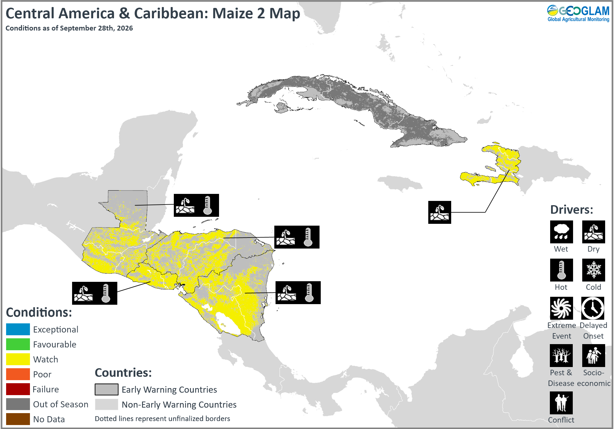
Crop condition map synthesizing Maize 1 (Primera season) conditions as of September 28th. Crop conditions over the main growing areas are based on a combination of inputs including remotely sensed data, ground observations, field reports, national, and regional experts. Conditions that are other than favourable are labeled on the map with their driver.
In Central America, harvesting of Primera season maize and bean crops is complete across Guatemala, El Salvador, Honduras, and Nicaragua and maize and bean conditions have been downgraded to poor in all areas due to extended dry spells and high temperatures this season which resulted in delayed Primera season planting and hampered crop development, particularly in the Dry Corridor region. The conditions are expected to reduce yields for both large-scale and subsistence farmers. Many subsistence farmers reported losses above 75 percent, and some crops died in the early stages due to erratic rainfall performance.
Land preparation is underway for the Segunda/Postrera season. The extended dry spells, high temperatures, and erratic rains are affecting the start of the season, and farmers are awaiting improved moisture conditions. Below-normal October to December 2026 rainfall and above average temperatures are forecast is forecast by the September outlooks corresponding with the forecast very strong El Niño conditions and a below-normal Atlantic Hurricane season (See Regional Outlook Pg 18.).
In Guatemala, El Niño-induced dry conditions and the onset of the canícula period (mid-summer dry spell) resulted in deterioration of Primera crops, particularly in the Dry Corridor. Additionally, irregular rains and high temperatures resulted in several disruptions to agricultural activities, including planting delays, non-planting, crop stress and wilting, and replanting. Conversely, localized parts of the Northern Transversal Strip and Alta Verapaz located in the north received abundant rains in mid-July that resulted in localized flooding and crop damage. Furthermore, a state fuel subsidy imposed during May and June in response to supply chain disruptions ended in early July, resulting in transportation cost increases. In Honduras, poor rainfall and prolonged dry spells during the growing season resulted in below average Primera season production. Most areas experienced severe rainfall deficits in July, coinciding with the onset of the canícula dry spell period that exacerbated moisture stress. The government declared a state of drought on August 19 across several municipalities, and a red alert has been declared due to significant crop losses. Conversely, localized flooding in Gracias a Dios and Olancho departments located in the east disrupted agricultural activities. Furthermore, high fertilizer prices resulted in increased production costs during the planting period and limited input use among subsistence farmers, contributing to below-average yields. High fertilizer prices are also expected to increase production costs for the upcoming Postrera season and continue to drive up costs of transportation, electricity, and water. In Haiti, harvesting of Printemps season maize and bean crops and main season rice crops finalized in August, while harvesting of main season rice continues, and overall conditions are favourable. Despite erratic rainfall reported during the Printemps season, irrigation systems supported crop production. Additionally, planting of Été season maize and bean crops continues, and while irrigation systems are supporting the start of the season, below-average and erratic rainfall are resulting in reduced water availability. In Cuba, planting and development of main season rice continue, and conditions are favourable despite persisting energy shortages this year that resulted in hampered plantings.
For detailed description of the pie chart please see description box on the bottom of the page.
Regional Outlook: Erratic rainfall to be followed by warmer and drier-than-normal conditions
Following the extremely poor performance of Primera 2026 rainfall season, there were substantial rainfall deficits between August 1st and September 20th, across much of Guatemala, southern and central Honduras, western Nicaragua, as well as in parts of El Salvador and southern Haiti (Figure 1-left). Rainfall totals were average to above average in northern Honduras, central and northern Haiti, eastern and southeastern Nicaragua, and parts of northern Guatemala. Hot days occurred more often and over more locations than usual, in Haiti and in Central America’s Pacific coast and Gulf of Fonseca areas, and in northwestern Guatemala, northern El Salvador, eastern Honduras, southwestern and northeastern Nicaragua. Average maximum temperatures for that period were record-high in Haiti and western Central America (Figure 1 middle-left).

SubC models and the ECMWF forecast a transition from near-average to above-average rainfall (e.g. in Guatemala) during late September–early October to increasingly drier conditions after that, in Central America. Heavy rains are possible during late September over portions of northwest Nicaragua and the mountains of Honduras and Guatemala, according to the NWS National Hurricane Center, and these will raise concerns for life-threatening flash flooding and landslides. During mid-September, central regions of Honduras were impacted by flooding from intense rainfall. The SubC ensemble largely maintains a drier-than-average outlook in the southern Caribbean region, indicating possibility of rainfall deficits developing in eastern and southern Central America and southern Haiti from late September through October.

Below-normal October to December 2026 rainfall is confidently forecast by the September outlooks from C3S, NMME, and WMO multimodel ensembles, in Honduras, Nicaragua, eastern Guatemala, eastern El Salvador, and southern Central America (> 70 percent chances) (Figure 1-right). Above-average temperatures are forecast across the region throughout late September to mid-October, based on the September 24th SubC. A high likelihood of temperatures reaching above 90th percentile levels will continue during October to December 2026. The outlooks correspond to forecasts of very strong El Niño conditions and a below-normal Atlantic Hurricane season.


Figure 1. Season precipitation and average maximum temperature anomalies, and 15-day and 3-month forecasts of precipitation anomalies.
Left: A CHC Early Estimate, which compares August 1st to September 20th, 2026 precipitation total to the 1996–2025 CHIRPS average for the same accumulation period. This uses CHIRPS3 Preliminary for September 1–20, 2026. Middle-Left: Average daily maximum temperatures for August 1st to September 19th, 2026. Middle-Right: Forecast next 15-day precipitation anomaly for September 24th to October 8th, from the CHIRPS3-GEFS forecast, which is a bias-corrected (to CHIRPS v3) version of the NCEP GEFS ensemble mean. Right: Multi-model ensemble forecast for the probability of below-normal, normal, and above-normal rainfall for October to December, 2026, rainfall based on September initial conditions, ECMWF SEAS5 and 6 NMME models, and a 1991-2020 baseline of model hindcasts. NMME data is from the IRI Data Library; ECMWF data is from Copernicus. Figure from CHC ECMWF and NMME.
Source: UCSB Climate Hazards Center
Pie Chart Description: Each slice represents a country’s share of total regional production. The proportion within each national slice is colored according to the crop conditions within a specific growing area; grey indicates that the respective area is out of season. Sections within each slide are weighted by the sub-national production statistics (5-year average) of the respective country. The section within each national slice also accounts for multiple cropping seasons (i.e. spring and winter wheat) and are a result of combining totals from multiple seasons to represent the total yearly national production. When conditions are other than favourable icons are added that provide information on the key climatic drivers affecting conditions.
Information on crop conditions in the main production and export countries can be found in the Crop Monitor for AMIS, published September 3rd, 2026.
Sources and Disclaimers: The Crop Monitor assessment is conducted by GEOGLAM with inputs from the following partners FEWS NET, JRC, WFP, ARC, AFSIS, MESA, ICPAC, FAO GIEWS, Applied Geosolutions and UMD. The findings and conclusions in this joint multi-agency report are consensual statements from the GEOGLAM experts, and do not necessarily reflect those of the individual agencies represented by these experts.