
Special Report
Report Information
El Niño 2026-2027: Regional Outlooks
Published October 16th, 2026
For access to all reports, please visit the Archive.
Please visit the Referencing Guidelines page for information on how to cite the Crop Monitor reports and products.
Highlights
El Niño is present, continuing to strengthen, and is forecast to persist through April 2027.
The current event is forecast to peak between October and December as a very strong event, often referred to as a "Super El Niño," with the potential to be the strongest on record.
Already, below-average yields have occurred across East Africa and Central America's main seasons due to El Niño-driven dry conditions.
In Southern Africa, the risk of drought is elevated during the 2026-2027 main cropping season.
After an extremely dry June to September 2026 rainfall season in East Africa, above-average rains are forecast, raising flood concerns in the eastern Horn.
After periods of erratic rainfall in Central America and the Caribbean, warmer, drier-than-normal conditions are expected to follow.
Below-average rainfall across parts of South and Southeast Asia is expected to continue.
Current Situation
El Niño conditions are now present and are likely to continue into 2027. Since April 2026, sea surface temperatures in the Niño 3.4 region of the tropical Pacific have risen rapidly. The latest weekly Relative Niño-3.4 index value was +0.9°C as of June 15th, according to the NOAA CPC. The June NOAA CPC forecast indicates that El Niño will continue to strengthen over the coming months, and there is a 63% chance of a very strong event (Index ≥ 2.0°C) at its peak from November 2026 to January 2027 (Figure 1).
Regional Outlooks for Areas of Concern
Southern Africa: Elevated drought risk during the 2026-2027 main cropping season
Below-average rainfall is expected across much of southern Africa from October 2026 to March 2027, driven by sustained strong El Niño conditions. Consistent with this, the Southern Africa Regional Climate Outlook Forum (SARCOF-33) indicates an increased likelihood of below-normal seasonal rains across central and southern areas. At the start of the season, SARCOF predicts below-normal October to December 2026 rainfall across southern Angola, southern Zambia, Zimbabwe, southern Malawi, central and southern Mozambique, Namibia, Botswana, and most of South Africa. Many of these areas are forecast to remain drier-than-normal through March 2027 (Figure 1 left and middle-left). Normal to above-normal October 2026 to March 2027 rains are forecast over most of the DRC, northwestern Angola, northern Zambia, northern Malawi, and northern Mozambique. In Madagascar, SARCOF-33 predicts mixed conditions, with a tendency toward below-normal seasonal rains in western areas.
The C3S, NMME, and WMO multi-model forecasts show similar regional outlooks indicating 40 to 50 percent probabilities of below-normal OND 2026 rainfall across Zimbabwe, Zambia, central-southern Malawi, Botswana, Mozambique, southwestern Madagascar, and the eastern half of South Africa. These also show below-normal rains are likely through March 2027 across many southern areas, with mixed conditions in the northern areas.
Overall, hotter- and drier-than-normal conditions could pose challenges for establishment of rainfed crops in some areas, based on the forecast of especially low near-surface soil moisture levels during November 2026 to January 2027. The NASA FLDAS-Forecast system predicts surface soil moisture levels in the driest one-third of historical forecasts in central South Africa, western Madagascar, southern Zambia, northeastern Namibia, and across much of Zimbabwe, Botswana, and Angola (Figure 1 middle-right). Variable rainfall onset dates have occurred in central and southern parts of the region during previous moderate-to-strong El Niños, indicating that rainfall observations and short-range forecasts may be best relied upon for that information.
Based on past El Niño events, the odds of moderate-to-severe drought tend to be higher when a negative Subtropical Indian Ocean Dipole (SIOD) mode is also present and disrupts moisture patterns in the southwestern Indian Ocean and Mozambique Channel region. As of September, model SIOD forecasts are trending negatively, though a large spread across models and low skill at this lead prevents a confident SIOD outlook.
Hotter-than-normal temperatures typically occur during moderate-to-strong El Niños during December to March (Figure 1-right). Associated with the forecast of a very strong 2026-2027 El Niño and regional atmospheric responses, dynamical models confidently predict much higher than normal temperatures during the November 2026 to April 2027 crop growing season, indicating these will often reach above the 90th percentile (> 70 percent chance). During the 2023-2024 El Niño, a mid-season dry spell with record-high temperatures developed over central Southern Africa. As of August 2026, global temperatures narrowly surpassed the previous record-high conditions in 2023, signaling that compounding heat and moisture stress on crops is a hazard to watch for again during the 2026-2027 El Niño.

October began with above-average rainfall in some areas—such as southern Madagascar, southern Mozambique, and portions of northern Zimbabwe and Zambia. During October 14th to 28th, drier-than-average conditions are forecast across southeastern Angola, Zambia, Zimbabwe, Botswana, central and southern Mozambique, central and eastern South Africa, Lesotho, eSwatini, and southern Madagascar.


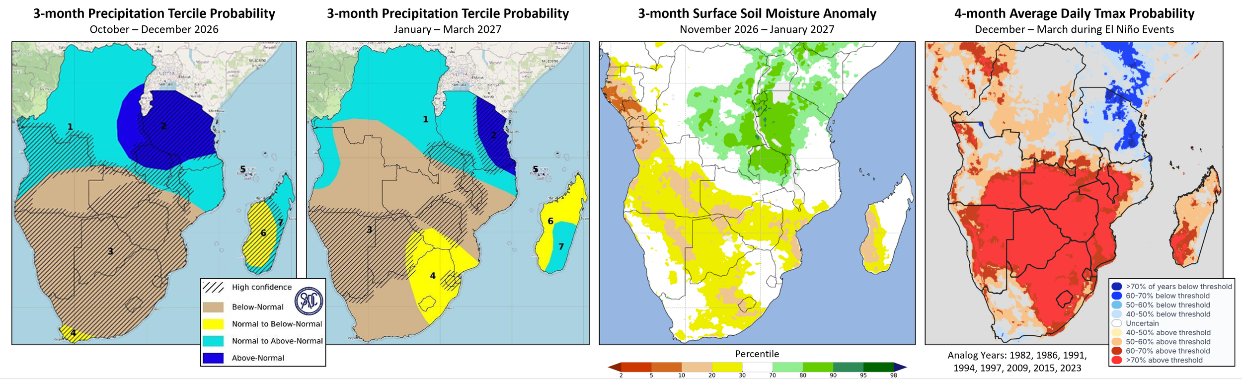
Figure 1. 3-month SARCOF-33 rainfall outlooks for the 2026/2027 season, NASA soil moisture forecast for Nov 2026 to Jan 2027, and historical seasonal December to March temperatures during moderate-strong El Niño. Left and middle-left: Rainfall outlooks for October to December 2026 and January to March 2027, from the 33rd SOUTHERN AFRICA REGIONAL CLIMATE OUTLOOK FORUM (SARCOF-33). The SARCOF-33 was produced by climate experts at the SADC National Meteorological and/or Hydrological Services (NMHSs) and the SADC Climate Services Centre (CSC), using model forecasts and a consensus procedure, during 25 to 28 August 2026, in Swakopmund, Namibia. Middle-right: Surface soil (0-10 cm) moisture percentile outlook for November 2026 to January 2027 from NASA’s FLDAS-Forecast system. The FLDAS forecast uses CHIRPS2 and MERRA-2 reanalysis data through August 2026 and forecasted meteorological conditions for September 2026 to January 2027 from the North American Multi-Model Ensemble (NMME) and the NCEP CFSv2 model. Right: Frequency of below-normal and above-normal December to March 2m maximum temperatures during moderate-to-strong El Niño years, based on CHIRPSv3 rainfall data during 8 years (1982, 1986, 1991, 1994, 1997, 2009, 2015, 2023). From the ENSO Explorer, an online research tool developed by the University of Botswana (UB) RAMP Lab, https://enso.ubramplab.org/. Source: UCSB Climate Hazards Center
East Africa: Extreme dry June to September 2026 rainfall season driven by El Niño
The June to September (JJAS) 2026 rainfall season was exceptionally poor in northern and western East Africa, driven by the strengthening El Niño. During June 1st to September 30th, 2026, drier-than-average conditions prevailed across Sudan, South Sudan, Uganda, western Kenya, northwestern Somalia, and western, central, and northern Ethiopia, with seasonal totals less than 30 to 75 percent of average in many areas (Figure 2 middle-left).
JJAS 2026 rainfall was consistent with El Niño-based outlooks (for example, the June 2026 ‘What the 2026 El Niño may mean for Ethiopia’s June - September Kiremt Rainy Season’). Still, the season also featured unusually high heat and extreme rainfall deficits. The season ranked among the driest on record across large areas of South Sudan, northern and eastern Uganda, western and northwestern Kenya, and parts of southwestern, western, northern, and central Ethiopia and southern Sudan (Figure 2 middle-right). Record-high maximum temperatures during JJAS 2026 were observed in rainfall-deficit areas (Figure 2-right), compounding seasonal moisture stress.
El Niño-driven severe dry and hot conditions reduced pasture and surface water availability and are likely to result in below-average crop yields in many locations across the region. In Ethiopia, El Niño-driven dry conditions often negatively impact Kiremt season growing areas in the central-northern highlands, where large populations reside, and below-normal rains can have substantial impacts on crop production, and in the arid northeast where JJAS rains are crucial for grazing conditions and water resources. Across western and northern East Africa, poor rainfall and prolonged dry spells reduced moisture available to crops during key phenological stages, with seasonal rainfall deficits of 100 to more than 300 mm observed across northeastern Uganda, western and North Rift Kenya, Kiremt-receiving areas of central, eastern, and northern Ethiopia, South Sudan, and southern Sudan. Below-average rainfall during late August and mid-September across much of the region limited opportunities for crops to recover from earlier deficits (Figure 2- left). Portions of central Ethiopia received above-average rainfall late in the season. Extreme heat continued to worsen dry conditions in southeastern Sudan during that time, including key crop-growing areas of Sennar, Blue Nile, and Gedaref states, as well as parts of central and northern South Sudan, including Unity, Warrap, and Bahr el Ghazal. In Ethiopia, the October to December rainfall season has begun with well-distributed and above-average rains in southern and eastern areas—also an El Niño outcome—with hopes for a more beneficial season during OND 2026 and limited crop losses if untimely rains impact crop harvesting.

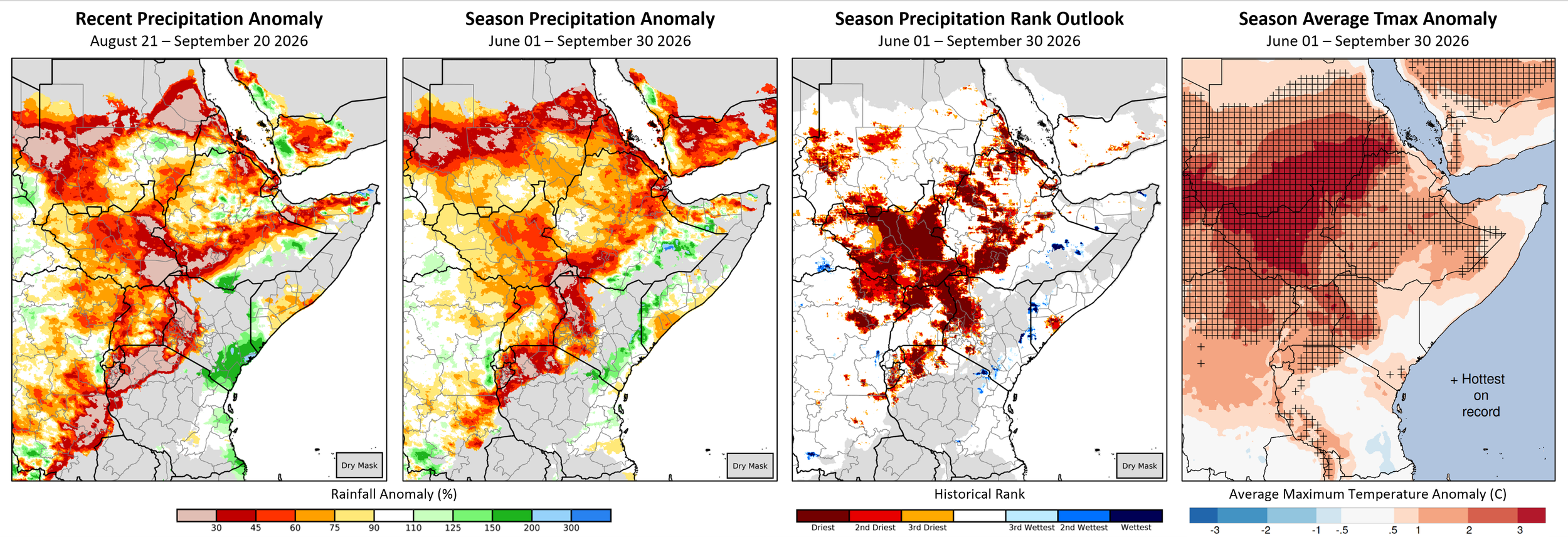
Figure 2. June to September 2026 rainfall and temperatures. Left and middle panels: CHC Early Estimates, which compare the August 21st to September 20th (Left) and June 1st to September 30th (middle panels) 2026 precipitation totals to the 1996–2025 CHIRPS averages for the same accumulation periods, based on percent of average and historical rank. Data: CHIRPS v3. Right: Average daily maximum temperatures for June 1st to September 30th, 2026. Data: CHIRTS-ERA5, a bias-corrected version of ECMWF ERA5. Source: UCSB Climate Hazards Center
October to December: Forecast above-average rains and flood concerns in the eastern Horn
El Niño and positive Indian Ocean Dipole (IOD) conditions tend to enhance October-to-December (OND) rains, raising the risk of heavy and damaging rainfall events, especially in the eastern Horn of Africa. These conditions are forecast during OND 2026. The positive IOD event is largely driven by very warm sea surface temperatures in the western Indian Ocean. Weekly IOD values from the Bureau of Meteorology have been positive since mid-September 2026, with the latest value of +0.88 °C, as of October 11th.
Figure 3 (left) compares the October forecast for OND 2026 El Niño and the Indian Ocean Dipole strength to past observations, highlighting four years that are within range of the 2026 forecast: 1982, 1997, 2015, and 2023. All of these produced above-normal rains in the eastern Horn. Above-average rains are expected to support pasture regeneration and replenishment of surface waters across pastoral areas. Heavy and persistent rains also increase flood risks in riverine, urban, and flash-flood-prone areas, as well as risks of landslides, displacement, disease outbreaks, and transportation disruptions.
The risks of flash flooding or riverine floods are highly elevated in southern Somalia and the Juba River and Shabelle River areas and northeastern and southeastern Kenya and the Tana River basin. These areas have frequently experienced highly above-average rainfall in past years (Figure 3 middle-left), and models strongly indicate above-normal OND 2026 rains (Figure 3 middle-right). Due to the potential for impacts like the 2023 and 1997 El Niños, the Intergovernmental Authority on Development (IGAD) broadcast a High-Level Call to Action to strengthen preparations to protect people and resources.
In southern Somalia, southern and southeastern Ethiopia, and eastern Kenya, above-average rains have already been observed during late September to early October. A CHC Early Estimates outlook indicates extreme rainfall surpluses for October 1st to 25th (Figure 3-right). FAO SWALIM issued a flood advisory along the Juba and Shabelle Rivers on October 13th, with a high risk of flooding at Jowhar where bankfull levels were expected in the coming days. During mid-to-late October, above-average rains are forecast in eastern parts of Somalia, while drier conditions are forecast in eastern Kenya, as of October 15th.

Leading up to the OND 2026 rainfall season, the higher-than-normal chances of above-normal rainfall in Ethiopia, Somalia, Kenya, Uganda, central and southern South Sudan, Rwanda, Burundi, and Tanzania were indicated by the Greater Horn of Africa IGAD Climate Prediction and Applications Centre (ICPAC) and National Meteorological and Hydrological Services’ regional climate outlook for OND 2026 and other multi-model ensemble forecasts. October initial condition OND forecasts maintain that outlook primarily in equatorial, eastern, and southern East Africa. In the north-west region, the forecast points to drier conditions as the rainfall season ends, which is consistent with the dry pattern observed in recent months.
In South Sudan, the extremely low rainfall during June to September 2026 led to a decline in national flooded extent between August and September. National flood extent is forecast to decrease through October, with a small rebound in November, based on a FEWS NET outlook. Uganda’s Ministry of Water and Environment warned that if above-average seasonal rains occur in the Lake Victoria basin, the resulting higher Nile River flow will raise downstream flood risks, including for the Sudd wetland region. Outcomes will depend on the extremity of rain and water management. Close monitoring of rainfall conditions is recommended throughout the OND 2026 season.
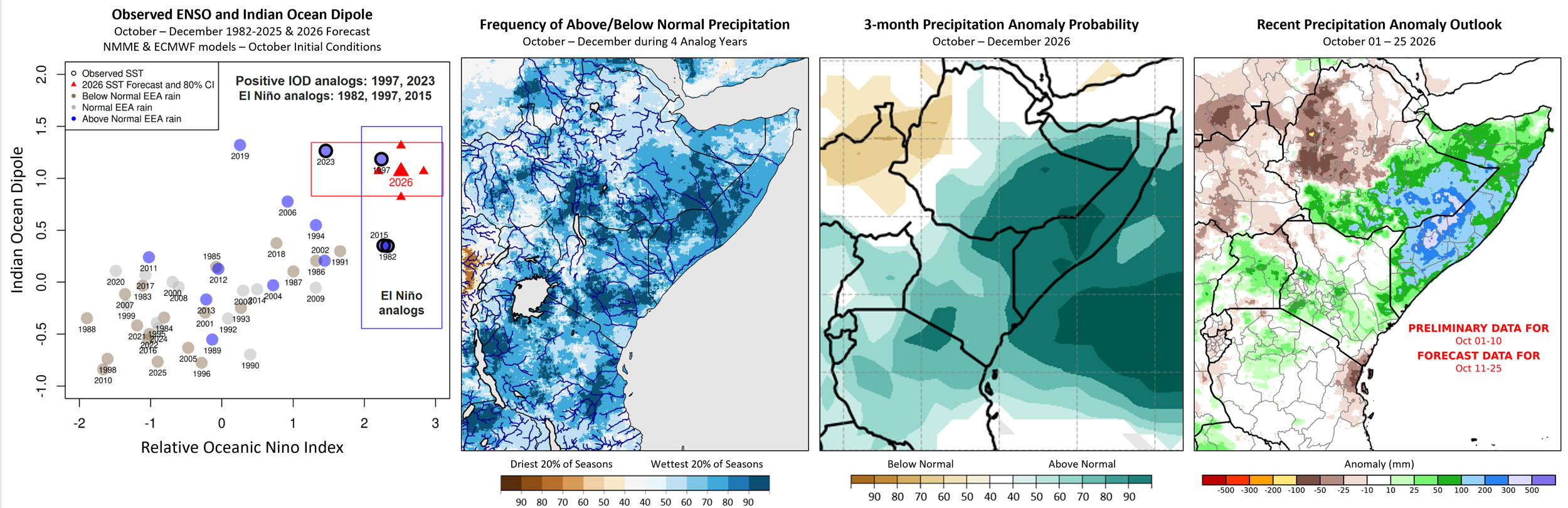
Figure 3. October to December 2026: Forecast El Niño and positive Indian Ocean Dipole, historical frequency of highly above-average rainfall, a 3-month rainfall forecast, and a recent rainfall anomaly outlook. Left: Current ENSO/Relative ONI (RONI) and Indian Ocean Dipole (IOD) forecast for OND 2026, compared to historical observations (scatterplot), and historical rainfall tercile outcomes (filled colors) in eastern East Africa (EEA; 8.5N-4.5S, 38E-50E). The October NMME and ECMWF mean OND 2026 forecasts for RONI and IOD are shown with a range of values within an 80% confidence interval (large and small red triangles, respectively), post-forecast bias-correction using historical 1991–2025 forecasts. The most relevant (to this forecast) historical years are identified, based on these intervals for RONI and IOD (black outlines). Left-middle: Using the four years identified by the OND 2026 RONI and IOD forecasts (left), this map shows the frequency of observed OND rainfall in highly above-average or below-average categories (> 80th percentile and < 20th percentile, respectively), based on CHIRPS v3 data. Middle-right: ECMWF and NMME multi-model ensemble probability forecast for OND 2026 rainfall tercile, October initial conditions, from UCSB CHC MME. Right: A CHC Early Estimate comparing recent precipitation totals to the historical CHIRPS average (1996-2025). The right panel shows the precipitation anomaly (mm) for October 1st to 25th, 2026, using CHIRPS preliminary data for October 1st to 10th and a 15-day CHIRPS-GEFS forecast from October 11th. Source: UCSB Climate Hazards Center
Central America and the Caribbean: Erratic rainfall to be followed by warmer and drier-than-normal conditions
After the extremely poor Primera 2026 rainfall season driven by El Niño, much of Guatemala, southern and central Honduras, western Nicaragua, El Salvador, and parts of southern Haiti experienced substantial rainfall deficits between August 1st and September 20th (Figure 4, left). Rainfall totals were average- to above-average in northern Honduras, central and northern Haiti, eastern and southeastern Nicaragua, and parts of northern Guatemala. Hot days occurred more often and over more locations than usual in Haiti and along Central America’s Pacific coast and Gulf of Fonseca areas, and in northwestern Guatemala, northern El Salvador, eastern Honduras, and southwestern and northeastern Nicaragua. Average maximum temperatures were record-high in Haiti and western Central America during that period (Figure 4 middle-left).

Dry conditions during the August to September planting period raised major concerns about negative impacts on El Salvador’s main bean cropping season, prompting a six-month state of national emergency as of October 7th, following crop losses of 20-30 percent during the first season (OCHA Oct. 12th update).
During late September–early October, a change in weather brought heavy rains to Guatemala, eastern, central, and western Honduras, and western Nicaragua (Figure 2 middle-right). In mid-September, intense rainfall flooded central Honduras. Concerns remain that recent heavy, irregular rainfall has not benefited the Segunda cropping season. During October 15th to 21st, above-average rains are forecast in northern Guatemala and northeastern Nicaragua. 30-day rainfall totals will likely be below normal across central and southern Central America and the Caribbean, based on the October 14th ECMWF.


Models continue to forecast moderate to high chances of below-normal October to December 2026 rainfall in Honduras, Nicaragua, eastern Guatemala, eastern El Salvador, and southern Central America, based on October initial conditions (Figure 4-right). Above-average temperatures are forecast across the region throughout late October to early November, based on the October 14th SubC. A high likelihood of temperatures reaching above 90th percentile levels will continue during October to December 2026. The outlooks correspond to forecasts of very strong El Niño conditions and a below-normal Atlantic Hurricane season.


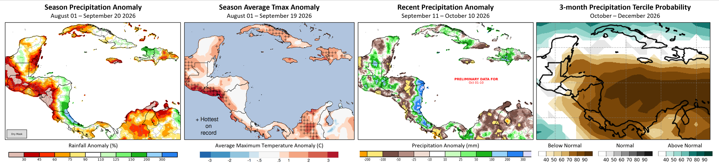
Figure 4. Precipitation and average maximum temperature anomalies for the start of the season, precipitation in recent weeks, and a 3-month precipitation tercile forecast. Left: A CHC Early Estimate comparing the August 1st to September 20th, 2026, precipitation total to the 1996–2025 CHIRPS average for the same accumulation period. Data: CHIRPS v3. Middle-Left: Average daily maximum temperatures for August 1st to September 19th, 2026. Middle-Right: Precipitation anomaly during September 11th to October 10th, 2026, using preliminary data for October. Right: Multi-model ensemble forecast for the probability of below-normal, normal, and above-normal rainfall for October to December 2026, based on October initial conditions, ECMWF SEAS5 and 7 NMME models, and a 1991-2020 baseline of model hindcasts. NMME data is from the IRI Data Library; ECMWF data is from Copernicus. Figure from CHC, ECMWF, and NMME. Source: UCSB Climate Hazards Center
South/ Southeast Asia: Below-average rainfall across parts of South and Southeast Asia is forecast to continue
The Southwest Monsoon season in India began with below-average May to June 2026 rainfall across western, central, and central-northern areas, according to CHIRPS data. Drier-than-average conditions continued during the peak and latter half of the season, July to September (JAS) 2026, in western, central-western, and southern India (Figure 5-left). JAS rains in extreme eastern locations were also below average. Wetter conditions, with above-average JAS rainfall, occurred in central-eastern and north-eastern areas. In central-western and parts of southern India, the drier-than-average season led to extreme JAS rainfall deficits, with record-low JAS 2026 totals in some areas, based on historical 1981-2025 CHIRPS data. Record-high JAS 2026 temperatures also occurred in southern India, according to ERA5 reanalysis data for the same period.


Rainfall was below average in northern Thailand, central and southern Vietnam, central and southern Philippines, northern and eastern Myanmar, and Indonesia during July to September 2026 (Figure 5-left), and from April 1st to October 5th. In late September, storms brought intense rain to southeastern areas. In Thailand, recent floods have impacted an estimated four million people and damaged 270,000 hectares of farmland. Hotter and drier-than-average conditions are forecast across central and southern India, Bangladesh, and across Southeast Asia during October 7th to 21st (Figure 5 middle-left). The ECMWF 30-day forecast for October 7th to November 5th (Figure 5 middle-right) indicates below-normal 30-day rainfall totals in central-western India and in northern and southern Southeast Asia. In the Philippines, rainfall is forecast to remain below average in October and likely continue into next year, based on El Niño expectations and consistent model rainfall forecasts.


The ECMWF 30-day forecast predicts wetter-than-normal conditions in extreme southern and northern India, northern Pakistan, and central Asia. Seasonal precipitation forecasts, based on October initial conditions, point to wetter-than-normal conditions for November 2026 to January (NDJ) 2027 in these areas, as well as in portions of Myanmar, Thailand, and northwestern Indonesia.
South Asia and Southeast Asia will very likely see highly above-average temperatures into next year. During JAS 2026, average maximum temperatures bypassed 1981-2025 extremes in southern Pakistan, southern India, Malaysia, the southern Philippines, and across much of Indonesia. In Indonesia, the dry-season peak from July to September 2026 was much drier and hotter than normal, with extreme lows in rainfall and highs in maximum temperatures. The ECMWF forecasts below-average rainfall and hot conditions to continue in Indonesia during October. Models indicate mixed rainfall conditions for November 2026 to January 2027.


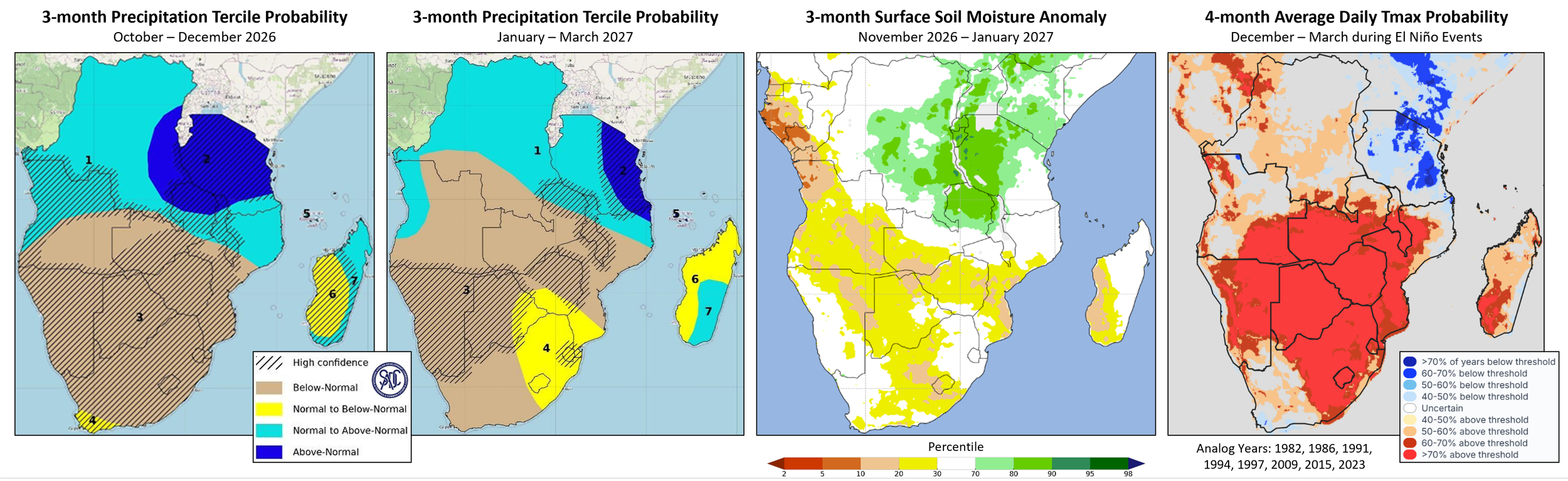
Figure 5. July to September 2026 rainfall anomalies, a 15-day hot and dry forecast, a 30-day precipitation forecast, and a 3-month precipitation forecast. Left: July 1st to September 30th, 2026, percent of average rainfall, compared to the 1996–2025 CHIRPS3 average, from UCSB CHC Early Estimates. Data: CHIRPS v3. Middle-left: Forecast 15-day average maximum temperatures for October 7th to 21st, 2026, shown where these will be abnormally hot (Tmax > 80th percentile and > 30 °C). Stippling shows locations where below-average rainfall is forecast for this period. Based on the 15-day CHIRTS-GEFS and CHIRPS-GEFS forecasts from August 27, 2026. From the UCSB CHC Heat Monitor. Middle-right: 30-day rainfall tercile probability forecast for October 5th to November 3rd, 2026. Based on the ECMWF IFS-SUBS-0.4 system forecast from October 5th, and a past 20-year baseline of model hindcasts. Right: 3-month rainfall tercile probability forecast for November 2026 to January 2027. Based on ECMWF SEAS5 and 7 NMME models, using October initial conditions and a 1991-2020 baseline of model hindcasts. NMME data is from the IRI Data Library; ECMWF data is from Copernicus. Source: UCSB Climate Hazards Center
References and Data Sources:
Prepared in Collaboration with:

Disclaimer: The Crop Monitor special report is produced by GEOGLAM with inputs from the following partners (in alphabetical order): Climate Hazards Center UCSB, NASA Harvest, and the University of Maryland. The findings and conclusions in this joint multi-agency report are consensual statements from the GEOGLAM experts and do not necessarily reflect those of the individual agencies represented by these experts. GEOGLAM accepts no responsibility for any application, use, or interpretation of the information contained in this report and disclaims all liability for direct, indirect, or consequential damages resulting from the use of this report.