Crop Monitor for Early Warning
Report Information
No. 115: Published May 7th, 2026
Conditions as of April 28th
For access to all reports, please visit the Archive.
Please visit the Referencing Guidelines page for information on how to cite the Crop Monitor reports and products.
Overview
In East Africa, conditions are mostly favourable for Belg season cereals in Ethiopia and main season cereals across the subregion, except in Rwanda, Burundi, Uganda, and Somalia due to recent rainfall delays and deficits.
In West Africa, agro-climatic conditions remain favourable for the 2026 to 2027 main season cereals, though conflict remains a concern in affected areas.
In the Middle East & North Africa, winter wheat continues to develop under mostly favourable conditions following improved rains, except in parts of Libya, Iraq, and Iran.
In Southern Africa, harvesting of main season cereals continues under mixed conditions, with ongoing concern regarding tropical cyclone and flooding impacts, dry conditions, and ongoing conflict in affected areas.
In Central & South Asia, conditions remain favourable for winter wheat crop development and the start of spring wheat planting.
In Southeast Asia, conditions are generally favourable for wet-season rice and maize in the south and dry-season rice and maize in the north, though conflict in Cambodia is expected to reduce dry-season rice production.
In Central America & the Caribbean, there is concern for the start of the Primera season in Guatemala due to rainfall deficits and high temperatures.
Crop Conditions at a Glance
Crop condition map synthesizing information for all Crop Monitor for Early Warning crops as of April 28th. Crop conditions over the main growing areas are based on a combination of inputs including remotely sensed data, ground observations, field reports, national, and regional experts. Regions that are in other than favourable conditions are labeled on the map with a symbol representing the crop(s) affected.
EAST AFRICA: Belg season cereals are developing favourably across Ethiopia, and conditions are mostly favourable for planting and development of main season cereals across the subregion, except in Rwanda, Burundi, parts of Uganda, and Somalia where recent rainfall delays and deficits may negatively impact crops. Forecasts indicate an elevated chance of below-normal rainfall for the June to September period (See Regional Outlook Pg. 6).
WEST AFRICA: Planting of main season maize and rice is underway along the Gulf of Guinea while harvesting of second season rice is nearing completion in Mali and Mauritania, and agro-climatic conditions remain favourable despite slight rainfall deficits in some areas.
MIDDLE EAST & NORTH AFRICA: Winter wheat continues to develop under mostly favourable conditions as early season deficits were followed by generally good rains in most areas. However, concern remains in parts of Libya, Iraq, and Iran, and escalating regional violence continues to disrupt production across parts of the Middle East.
SOUTHERN AFRICA: Harvesting of main season cereals continues under mixed conditions, with ongoing dry concerns in parts of Angola, eastern Zimbabwe, southern Mozambique, eastern South Africa, and southern Madagascar. Planting of winter wheat is just beginning under favourable conditions.
CENTRAL & SOUTH ASIA: Winter wheat crops continue to develop under favourable conditions, and planting of spring wheat is underway with a favourable start to the season. In Afghanistan, conditions are favourable despite below-average October 2025 through April 2026 rains.
SOUTHEAST ASIA: In the south, harvesting of wet-season rice and maize is underway, while planting of dry-season rice continues. In the north, harvesting of dry-season rice and maize is underway, and sowing of wet-season rice has started in southern Viet Nam. Overall conditions are favourable, though ongoing conflict in Cambodia is expected to reduce dry-season rice production.
CENTRAL AMERICA & CARIBBEAN: Land preparation for the Primera season is underway, and planting is just beginning in Guatemala with concern regarding below-normal rains and high temperatures that are forecast to continue (See Seasonal Forecast Alert Pg. 17). In Cuba, severe fuel shortages since January are negatively impacting ongoing agricultural activities.
Global Climate Outlook: Two-week forecast of areas of above or below-average precipitation
The two-week forecast (Figure 1) shows a chance of above-average precipitation over central Mexico, northern and northeast Brazil, southern Norway, southwestern Sweden, Estonia, eastern Latvia, northeastern Lithuania, central Russia, southern South Sudan, northern and western Uganda, eastern and central Democratic Republic of the Congo, northern Angola, northcentral South Africa, western Kazakhstan, northwestern Turkmenistan, western Uzbekistan, southern China, Indonesia, and eastern Australia.
There is also a risk of below-average precipitation over central and western Canada, western Cuba, southern Guatemala, Honduras, eastern El Salvador, western Nicaragua, southern Costa Rica, northern Colombia, Venezuela, Guyana, southeastern Bolivia, Paraguay, southern Brazil, Uruguay, northern and central Argentina, southern Chile, Portugal, Spain, southern Italy, southern Albania, southern Greece, northern Russian Federation, western Türkiye, Syria, northern Morocco, northern Algeria, southern Senegal, The Gambia, Guinea-Bissau, Guinea, Sierra Leone, Liberia, southern Mali, western and southern Burkina Faso, northern Nigeria, southeastern Chad, western Ethiopia, northeastern Tanzania, northern Madagascar, western South Africa, northern and eastern Kazakhstan, central Uzbekistan, southern Mongolia, northern and southwestern China, central India, Myanmar, Thailand, Laos, Viet Nam, Cambodia, southern Japan, and the central and southern Philippines.
Figure 1: IRI SubX Precipitation Biweekly Probability Forecast for 4 – 17 April, issued on 27 March 2026. The forecast is based on statistically calibrated tercile category forecasts from three SubX models. Source: IRI Subseasonal Forecasts Maproom
Climate Influences: El Niño forecast to develop during May to July 2026
Neutral ENSO conditions are present. El Niño conditions are confidently forecast from mid-2026 to early 2027. El Niño conditions may develop soon—during May to July 2026 (61 percent chance)—and could become a moderate or strong event. According to the April 2026 NOAA CPC ENSO outlook, there is an 87 to 92 percent chance of El Niño conditions from July 2026 to January 2027.
El Niño events tend to enhance rainfall in Central Asia, southern North America, south-eastern South America, southern Europe, eastern and southern East Africa, and southern and eastern China. Drier-than-average conditions tend to occur in Central America, the Caribbean, northern South America, parts of western and northern East Africa, the Sahel region, Southern Africa, India, Northern China, the Maritime Continent, and Australia.
Global temperatures for March 2026 were the fourth warmest on record, according to the Copernicus Climate Change Service Climate Bulletin. The likelihood of extreme conditions during the coming year will increase as El Niño warms global temperatures.
During April 2026, abnormally hot conditions occurred in Southeast Asia—especially in Thailand, Laos, Cambodia, and Vietnam—as well as in West Africa in Benin, Burkina Faso, and Nigeria, and in El Salvador and Mexico. During May 2026, above-average temperatures are forecast in West Africa, East Africa, central Southern Africa and Madagascar, central and northern Asia, Southeast Asia, eastern Australia, western Canada, the western United States, northwestern Mexico, Central America, the Caribbean, and northern and central South America.
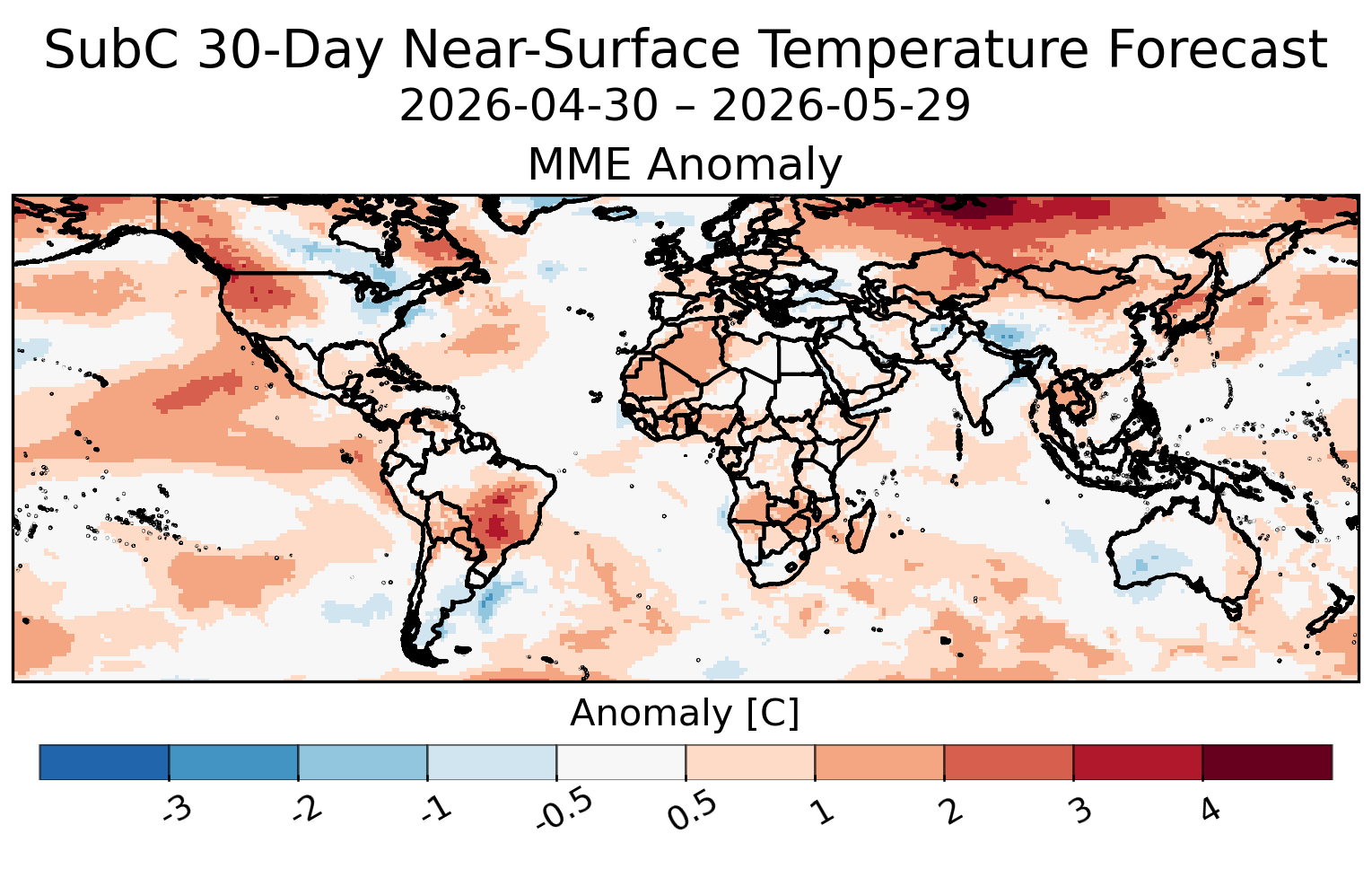
Figure 1. Average temperature anomaly forecast for the next 30 days starting on 30 April 2026, from five Subseasonal Consortium (SubC) models. SubC data accessed from the IRI Data Library. Map source: UCSB Climate Hazards Center.
East Africa
Crop condition map synthesizing Maize 1 crop conditions as of April 28th. Crop conditions over the main growing areas are based on a combination of inputs including remotely sensed data, ground observations, field reports, national, and regional experts. Conditions that are other than favourable are labeled on the map with their driver.
Across northern East Africa, winter wheat harvesting finalized in Sudan under poor conditions due to ongoing conflict. Belg season maize crops are in the vegetative to reproductive stage in Ethiopia, while planting of main season cereals is underway in South Sudan and Yemen, and overall conditions are favourable with normal crop development.
Across southern East Africa, planting and development of main season cereals is underway across Uganda, Kenya (long rains), Somalia (Gu season), Rwanda, Burundi, and the United Republic of Tanzania. Growing conditions are mostly favourable, with recent rainfall improvement across unimodal central and southern areas in the United Republic of Tanzania. Conversely, recent drier than normal conditions are causing concern in Rwanda, Burundi, and central and western bimodal areas of Uganda. While current impacts on crop biomass are mixed in Rwanda and Burundi, production shortfalls are likely if below-average rainfall continues. In Somalia, antecedent dry and hot conditions were followed by a delayed onset of the April to June Gu rains (See Regional Outlook Pg. 6).
The season has been categorized by an extremely early rainfall onset by up to a month in some areas, including in Kenya, Rwanda, Burundi, parts of the United Republic of Tanzania, and some southern Belg cropping areas in Ethiopia. Extreme rains in March resulted in flooding and landslides across Kenya, parts of Uganda, southern United Republic of Tanzania, and Ethiopia. Conversely, a dry spell in April then impacted many of these same areas, though the earlier rains mitigated much of the negative impacts. Throughout west and northern areas of East Africa, below-normal rainfall is forecast during the June to September period, consistent with patterns in similar El Niño years (See Climate Influences Pg. 3 and Regional Outlook Pg. 6).
Crop condition map synthesizing Maize 2 conditions as of April 28th. Crop conditions over the main growing areas are based on a combination of inputs including remotely sensed data, ground observations, field reports, national, and regional experts. Conditions that are other than favourable are labeled on the map with their driver.
Northern East Africa & Yemen
In Sudan, harvesting of winter wheat finalized in April with below-average yields expected due to ongoing conflict. In South Sudan, planting of first season cereals is just beginning under favourable conditions. In Ethiopia, Belg season maize crops are in the vegetative to reproductive stage for harvest from June, and overall growing conditions remain favourable across the country with above-average cumulative rains across the Belg cropping areas (See Regional Outlook Pg. 6). In Yemen, sorghum planting continues under favourable agro-climatic conditions. The rainy season began earlier than usual, with low-intensity rainfall recorded from March 20, followed by intensification from March 27 that triggered severe flooding and affected more than ten governorates. While the rains were generally beneficial for cropping activities, protracted conflict and related challenges continue to limit production potential.
Crop condition map synthesizing Sorghum 1 conditions as of April 28th. Crop conditions over the main growing areas are based on a combination of inputs including remotely sensed data, ground observations, field reports, national, and regional experts. Conditions that are other than favourable are labeled on the map with their driver.
Southern East Africa
In Somalia, planting of Gu season cereals is just beginning with concern due to delayed rainfall onset, as well as antecedent dry conditions during October to December 2025 and a hotter than normal January to February 2026 period. Light to moderate rainfall occurred during mid-March, signalling the approach of the April to June Gu rains, and some farmers began dry planting cereals in late March. However, dry conditions persisted across most areas, and seasonal rainfall as of late April has been less than 30 to 45 percent of average across most areas, except localized areas in the southwest and northwest. Mixed rainfall conditions are forecast through mid-May, which may bring average to localized above-average rainfall. However, this will only partly improve seasonal rainfall totals, and poor distribution will remain a concern (See Regional Outlook Pg. 6). During past years with similar El Niño conditions, sorghum yields were normal to below normal in the major producing sorghum regions. In Kenya, second season rice crops are in the vegetative to reproductive stage under favourable conditions in rice-growing areas of the centre and west. Additionally, planting of long rains maize and sorghum crops continues throughout the country under favourable conditions despite mixed rainfall outcomes over the last month. The March to May rains began early with above-average amounts, and average to above-average precipitation is expected to continue through May. However, the expected shift to El Niño conditions in the coming months increases the probability of below-average long rains between June and September in unimodal and major producing regions in the western half of the country (See Climate Influences Pg. 3 and Regional Outlook Pg. 6). In Uganda, planting and development of main season cereals is underway across the country, and there is concern in some bimodal areas, including in the centre and west, where recent dry conditions are hindering crop establishment. However, forecast average March to May cumulative rains in bimodal areas are expected to benefit production, particularly among smallholder farmers. In Rwanda and Burundi, Season B maize crops are in the vegetative to reproductive stage, and conditions have been downgraded to watch due to recent drier than normal outcomes over the last month. However, impacts on crop biomass are currently mixed. Additionally, planting of Season B rice continues in Burundi under favourable conditions. In the United Republic of Tanzania, Masika (bimodal regions) and Msimu (unimodal regions) crops are in the vegetative to reproductive stage across the country, and overall conditions are favourable. In central and southern unimodal rainfall areas, recent rains mitigated prior concerns regarding erratic rainfall outcomes between November 2025 and January 2026. However, some flooding was reported in the south.
For detailed description of the pie chart please see description box on the bottom of the page.
Regional Outlook: Poor rainfall distribution during late March to mid-April 2026, drought continues in Somalia, and a forecast El Niño event brings risks to the region
Several weeks of below-average rains during late March to mid-April 2026 raise concerns about potential negative crop impacts during early crop development stages. During March 26th to April 25th, 2026, these forecast poor rainfall conditions (see the April 2026 East Africa Regional Alert) resulted in moderate-to-severe rainfall deficits in Uganda, Rwanda, Burundi, Tanzania, portions of central and south eastern Ethiopia, and in most areas of Kenya and Somalia. Preliminary estimates show less than 30 to 60 percent of average rainfall between late March and mid-April 2026 (Figure 1 top-left). Rainfall was above average elsewhere– in central-southern and northern South Sudan, southern Sudan, northern, central-western and central-eastern Ethiopia, northeastern Kenya, and in localized areas of southeastern Ethiopia and southwestern Somalia. Rainfall totals for March 1st to May 10th will likely be average to above average across most areas, due in large part to abnormally wet conditions during March. February was also wetter than average. Rainfall deficits for March 1st to May 10th will likely persist in Burundi, southwestern and central Uganda, southeastern Ethiopia and south-central and eastern Somalia (Figure 1 top-middle).
In Somalia, following a failed October to December 2025 Deyr season and a hot and dry January to March 2026, pasture resources deteriorated, many water resources dried up, and agricultural production was severely hampered. As of April 25th, NDVI shows that vegetation conditions remain below average and many water points in central-southern Somalia are near dry. A late rainfall onset in central Somalia and poor rainfall amounts and distribution in southern and central Somalia are likely to hamper recovery of agricultural, pasture and water resources. Severe drought continues to deepen humanitarian needs with at least 2 million Somalis estimated to be facing acute (IPC 4) levels of hunger (OCHA, April 6th 2026).
In Somalia, seasonal rains have been less than 30 to 45 percent of average across most areas, except localized areas in the southwest and northwest where rains were above average. Forecast mixed rainfall conditions, which may bring average to localized above-average rainfall during April 30th to May 14th (Figure 1 top-right), will only partly improve seasonal totals and poor distribution will remain a concern. Opportunities for more substantial improvement to seasonal rains typically decline after mid-May, for example, in Hiraan and Bay regions which typically receive peak rainfall during late April-early May. Forecast warmer-than-normal May 2026 temperatures may accelerate the drying of soils after rain events.
In other areas with recent rainfall deficits (Figure 1 top-left), above-average rainfall during late April and forecast above-average amounts during early May are expected to improve conditions. However, the variable timing of rains, characterized by a very wet and early start to the season, and much drier than average conditions during late March to mid-late April, could have negatively impacted some crops. Despite the early April rainfall deficits, current conditions across Kenya are favourable due to enhanced rainfall in late April and earlier above average soil moisture that helped sustain the crops through the dryspell.
Above-average rains are forecast in western and northern Kenya, southern, central, and eastern Ethiopia, Rwanda, Burundi, northwestern Tanzania, Uganda and parts of central and northern Somalia during April 30th to May 14th (Figure 1 top-right). Associated with forecast wetter-than-average conditions are elevated risks of flooding. Recently, prolonged heavy rains produced floods and landslides in Mbeya, southwestern Tanzania where at least 20 people lost their lives and about 600 were displaced (Reliefweb). In Kenya, heavy rains in late April destroyed property and displaced families in Nairobi, Kwale and Mombasa. In response to rising river levels across Kenya and forecasted continued enhanced rainfall across the central Highlands, the Kenya Meteorological Services Authority (KMSA) has issued a flood alert for Garissa and Tana River counties within the first week of May.
Due to potential negative impacts of El Niño on rainfall during the June to September 2026 season, the transition of seasonal rains into northern East Africa will need to be monitored. Rainfall conditions throughout May 2026 are uncertain. There is low agreement among subseasonal SubC multi-model ensemble and ECMWF forecasts from April 30th. Neither agrees with ICPAC’s earlier and largely above-normal May 2026 rainfall forecast. Above-average temperatures are forecast across much of East Africa during May 2026.
There will be elevated chances of below-normal June–September 2026 rains in western and northern areas, according to seasonal climate model forecasts including the WMO (Figure 1 bottom-left), C3S, and CHC MME forecasts from April. The outlook is consistent with the drying effects of many recent El Niño years (Figure 1 bottom-right). Current ENSO neutral conditions are forecast to transition to El Niño during May to July (61 percent chance). El Niño conditions are conducive for above-normal rainfall during the short rains/Deyr 2026 season. NMME models indicate above-normal rainfall in eastern Ethiopia and Somalia beginning in September 2026 and across East Africa during September to November 2026.
Figure 1. The Top-left and Top-middle panels are CHC Early Estimates, which compare the March 26th to April 25th, 2026 (Top-left) and March 1st to May 10th (Top-middle) precipitation totals to the 1996–2025 CHIRPS averages for the same accumulation period. These panels use CHIRPS3 Preliminary for April 1–25, 2026. A bias-adjusted NCEP GEFS forecast (CHIRPS3-GEFS) is used for the 15-day forecast from April 26th. Top-right: Forecast next 15-day precipitation anomaly for April 30th to May 14th, from the CHIRPS3-GEFS forecast. Bottom-left: WMO multi-model ensemble probability forecast of June to September (JJAS) 2026 precipitation terciles, based on April initial conditions. Bottom-right: The frequency of below-normal JJAS rainfall during years with concurrent El Niño conditions (1982, 1987, 1991, 1994, 1997, 2002, 2004, 2015, 2023), relative to 1991–2020 CHIRPS v3 terciles. In areas with orange to dark red colors, below-normal rains occurred in four to nine years (40 to 100%). Gray areas are typically dry during JJAS (mean rainfall < 50 mm). From UCSB CHC.
Source: UCSB Climate Hazards Center
West Africa
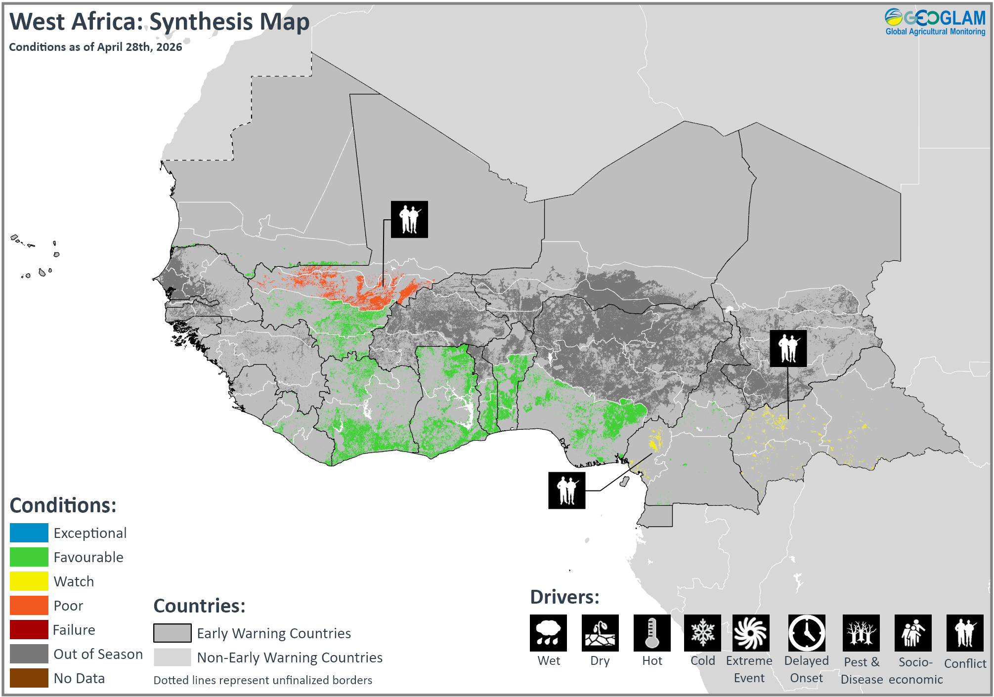
Crop condition map synthesizing crop conditions as of April 28th. Crop conditions over the main growing areas are based on a combination of inputs including remotely sensed data, ground observations, field reports, national, and regional experts. Crops that are in other than favourable conditions are labeled on the map with their driver.
In southern West Africa, planting of main season maize and rice is underway along the Gulf of Guinea, including in Liberia, Côte d’Ivoire, Ghana, Togo, Benin, Nigeria, Cameroon, and the Central African Republic. Along the Sahel, harvesting of second season rice is nearing completion in Mali and Mauritania. Agro-climatic conditions remain favourable throughout the subregion. However, agricultural activities in central Mali, southwestern Cameroon, and the Central African Republic continue to be impacted by persistent conflict. According to the CHIRPS rainfall totals from March 1 to April 15, the southern part of the subregion from Liberia to the Central African Republic received above-average rainfall, ranging from 75 mm to more than 200 mm, with localized areas receiving more than 300 mm in southern Liberia, southern Côte d’Ivoire, southwestern Ghana, southeastern Nigeria, and southwestern Cameroon. However, there is a slight-to-moderate deficit in central and western Liberia, southern Nigeria, southern Cameroon, and southwestern Central African Republic.
In Togo, forecasts for the 2026/27 growing season indicate generally beneficial rains in southern areas, with some potential dry spells. Additionally, the government has strengthened production support in the form of input provision, credit access, advisory support, and the expansion of planned agricultural development zones. In Cameroon, a timely arrival of rains in March likely supported planting activities in March and April, and seasonal forecasts indicate average rains through May that are expected to support crop establishment and development. Additionally, a newly established government agricultural support program provides subsidized inputs, including fertilizers, herbicides, and improved seeds, to smallholder and subsistence farmers. Ongoing conflict in the northwest and southwest regions is expected to continue undermining productive capacity, and elevated input prices are likely to constrain agricultural activities.
Additionally, according to the Regional System for the Prevention and Management of Food Crises (PREGEC) key message updated in March 2026, the final results of the 2025/26 agricultural season show an estimated cereal production of 80.4 million tonnes, representing a 4 percent increase compared to the previous season and a 7 percent increase compared to the five-year average. Average per capita cereal production remained stable, with a slight 1 percent increase compared to last year and equivalent to the past five-year average.
Middle East & North Africa
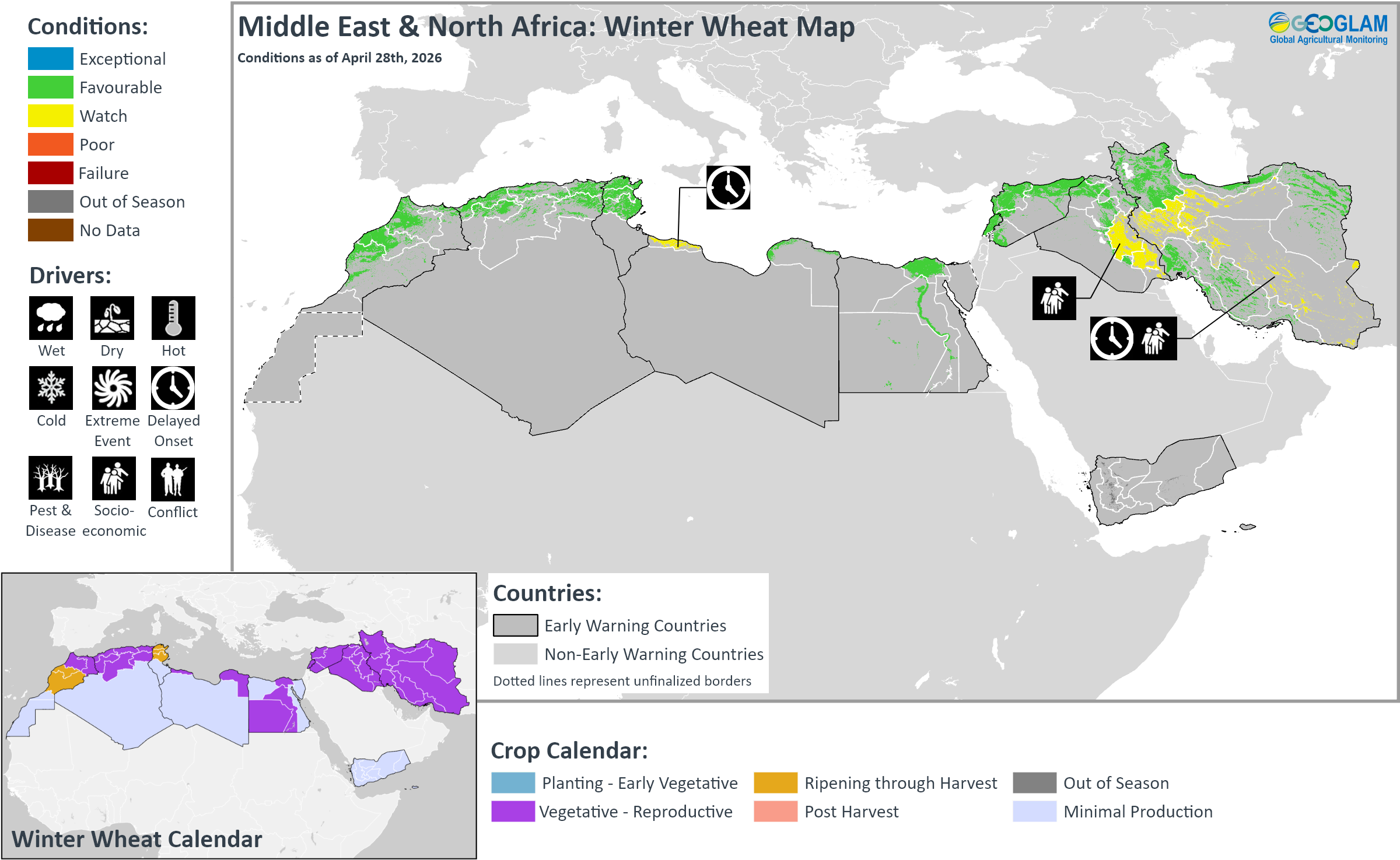
Crop condition map synthesizing Winter Wheat conditions as of April 28th. Crop conditions over the main growing areas are based on a combination of inputs including remotely sensed data, ground observations, field reports, national, and regional experts. Crops that are in other than favourable conditions are labeled on the map with their driver.
Across the Middle East and North Africa, winter wheat continues to develop across Morocco, Algeria, Tunisia, Libya, Egypt, Lebanon, Syria, Iraq, and Iran, and harvesting is just beginning in some areas. Growing conditions are mostly favourable with recent improvements in northern Morocco, Algeria, and northwestern Syria. However, early-season dry conditions continue to negatively affect crop performance in northwestern Libya and parts of central Iran. In southern Iraq, crop biomass remains below average due to a government decision to limit the area of cultivation using surface water. Furthermore, escalating regional conflict and related supply chain disruptions continue to impact parts of the Middle East. Flooding at the end of March also impacted parts of Syria, Iraq, and Iran, though the overall impact on crops is expected to be minimal.
In Morocco, a drier than normal start to the season from October to mid-November 2025 was followed by a shift to improved rains at the end of November and in December 2025 and January 2026 across the country and in February 2026 in the north. Total rainfall since October 2025 is the highest of the last 25 years in the centre and northwest of the country (from Tadla Azizal and Chaouia to Tanger-Tétouan). Crop biomass is now above average in all regions, including in the east (Tadla Azilal, Maknes, and Oriental) where cereal growth was initially delayed. However, prolonged flooding in February damaged crops in localized areas of Gharb and Tanger Tetouan. Harvesting is expected to begin in May in the west, which was less affected by delayed growth, and overall cereal prospects are favourable. In Algeria, northwestern areas experienced low rainfall in October and November 2025 that resulted in delayed winter cereal growth. However, improved moisture conditions from December 2025 benefitted winter cereals. Crop biomass is now average to above average in Tiaret, an important cereal-producing region where initial crop growth was delayed, as well as in Saida and Tissemlit. In the northeast, beneficial rains since the start of the season have resulted in well above-average cereal biomass (from Medea to the Tunisian border). In Tunisia, conditions remain favourable for winter cereals with above-average crop biomass in all producing governorates, including in the east (Zaghouan, Ben Arous, and Nabeul) where crop biomass was initially well below average. The season began with rainfall deficits during October and November 2025 that delayed the start of cereal growth, particularly in the east. However, rainfall improvements since December 2025 through April 2026 have supported the normal development of winter cereals. Harvesting is expected to start at the end of May for barley and in June for wheat. In Libya, barley and wheat harvesting is just beginning under mixed conditions. There is concern in the northwest (from Az Zawia to Misurata), likely due to a reduction of the sown area, while conditions around Banghazi remain favourable, except in Darna. In Egypt, winter wheat crops are in the vegetative to reproductive stage for harvest from May, while sowing of summer-planted rice is just beginning, and overall conditions remain favourable.
In Syria, a dry start to the season was followed by rainfall improvements from December 2025, and cumulative rains since October are now above average in all governorates, including in the main producing Hassakeh governorate. However, heavy rains from mid-March and early April resulted in widespread flooding across northern areas (Aleppo, Idleb, Ar-Raqqa, Al-Hasakeh, and Deir-ez-Zor) and damaged 600 hectares of wheat in southern Aleppo and Idleb. Overall biomass is above average, including in the northwest (Aleppo, Idleb, Hama, and Homs), where initial crop growth was strongly delayed. Overall wheat production is forecast at 2.5 million tons, supported by improved agricultural indicators and upgraded grain storage infrastructure. In Iraq, barley harvesting is underway while wheat harvesting will commence in May, and overall prospects are favourable. A drier than normal start to the season in October and November 2025 was followed by rainfall and moisture improvement since December 2025 through April 2026 across the country. Crop biomass is above average in the main producing northern areas, while biomass is well below average in the south (Babil, Qadissiya, Wassit, Thi-Qar, and Missan) due to the government’s decision to reduce the area irrigated with surface water by 50 percent. Only Najaf shows above-average crop biomass due to modern irrigation development. Additionally, the government approved rice cultivation this year for some provinces, including Najaf, Diwaniyah, Muthanna, and Kifl, and planting is expected to begin soon. In Iran, a drier than average start to the season in October and November 2025 was followed by abundant rains and moisture improvement from December 2025 to early February 2026, and cumulative rainfall since October is near to above average. The good rains combined with above-average temperatures since February have benefitted cereal growth and replenished reservoirs, which were at very low levels in November 2025. In the northwest (from the Iraqi border to Tehran and from Zanjan to Lorestan), dry conditions returned from mid-February to early March, when rainfall was 50 percent below normal, but this was followed by a shift back to good rains from mid to late-March. Overall biomass is mixed, with average to above-average biomass in the main wheat-producing northern provinces (West and East Azerbayejan and Ardebil in the northwest, Golestan and Khorasan in the northeast) and in the main wheat-producing central-southern provinces (Khuzestan and Fars). Conversely, biomass is below average in the centre (Hamedan, Markazi, Semnan, Esfahan, and Kordestan), likely due to dry conditions at the start of the season, which possibly reduced sowings. Furthermore, since February 28, 2026, the country has experienced a sharp and sustained escalation in hostilities, and the security situation remains highly volatile.
Southern Africa
Crop condition map synthesizing maize conditions as of April 28th. Crop conditions over the main growing areas are based on a combination of inputs including remotely sensed data, ground observations, field reports, national, and regional experts. Crops that are in other than favourable conditions are labeled on the map with their driver.
Across Southern Africa, harvesting of main season cereals is underway in all countries, including Angola, Namibia, Botswana, Zimbabwe, Zambia, Malawi, Mozambique, Madagascar, South Africa, Lesotho, and eSwatini, and will continue through May and into early June in some areas. Yield prospects remain mixed, with ongoing concern in parts of central and eastern Madagascar regarding the impacts of tropical cyclones in January and February. In Mozambique, erratic rains, including periods of heavy rains and flooding as well as a severe dry spell, could result in production declines in parts of the south and centre. In parts of west and central Angola, eastern Zimbabwe, and southern Madagascar, erratic rains resulted in rainfall deficits that could impact cropping outcomes. In eastern South Africa, dry conditions in February had a negative impact on yellow maize production, though overall maize production at the national level is expected to be above average. Furthermore, concern remains in the conflict-affected areas of Cabo Delgado region in Mozambique and Kivu region in the Democratic Republic of the Congo. Elsewhere, conditions are favourable with near-normal yields expected, and well-above-average yields are possible in the Eastern Cape, Free State, and North West regions of South Africa. Additionally, planting of winter wheat is just beginning in Zimbabwe, South Africa, and Lesotho under favourable conditions.
In Angola, deficits are particularly concerning in parts of the northwest and west, which recorded some of the lowest January, February, and March rains on the CHIRPS record. Conversely, western areas received heavy rains in early April that resulted in localized flooding but also helped to improve vegetation conditions and water reserves. However, it is too late in the season for significant crop improvement, and production outcomes are likely to be below average in parts of the centre and west. In Botswana, severe flooding between March 15 and 19 affected multiple areas of the Central district, though yield prospects remain favourable. In Zimbabwe, the 2025/26 season was mixed, with southern parts of the country receiving above-normal rainfall while northern parts received generally normal rainfall. A significant mid-season dry spell beginning around January 25 and lasting through mid-February 2026 resulted in crop wilting at critical physiological stages, particularly in parts of the east. However, strong performance elsewhere in the country is expected to offset these losses. In Malawi, most areas received above-average rainfall during the October 2025 to March 2026 rainy season. However, localized dry spells of three to four weeks impacted southern areas between January and February 2026, leading to average cumulative rainfall in those areas. Conversely, heavy rain in mid-March resulted in flash flooding in parts of the centre and south, resulting in some localized crop damage. Despite the dry spells and flooding impacts, overall harvest at the national level is expected to be average. In Mozambique, severe flooding in January in the southern part of the country was followed by a prolonged 40-day dry spell in February and March with high temperatures, and then a shift back to heavy rains in March that triggered localized flooding in the south and central areas. The sequential climatic shocks resulted in crop and livestock losses across parts of the south and central regions. Preliminary data indicate that 449,000 hectares of crops, representing 4.9 percent of the planted area, were affected, including maize, beans, and vegetables, particularly in Gaza, Maputo, and Sofala provinces. Additionally, limited seed availability and degraded soil conditions are further hindering replanting efforts. The 2025/26 harvest is expected to be near average, though quantities will vary at the subnational level, with below-average amounts expected in the south, mixed amounts in the centre, and above-average amounts in the north. Atypical dry conditions are expected to persist through September. Furthermore, conflict in Cabo Delgado continues to result in limited agricultural engagement. In Madagascar, the Grand South region experienced cumulative rainfall deficits from early February to late April and atypically high temperatures since January, which led to one of the driest seasons on record, damaging short-cycle maize and bean crops. Additionally, in cyclone-affected areas along the northwest and eastern coast, prolonged flooding and widespread crop destruction present uncertainties for yield outcomes. Cyclone Fytia made landfall on the northwest coast of Madagascar on 31 January, flooding approximately 25,000 hectares primarily in Boeny and southern Sofia regions. Cyclone Gezani followed on 10 February, making landfall near Toamasina on the east coast and flooding approximately 14,000 hectares, with impacts concentrated in Alaotra Mangoro and extending into Atsinanana and Analamanga regions. Conversely, rice crops are in the vegetative to reproductive stage under favourable conditions despite rainfall deficits received in some areas. In South Africa, conditions are mostly favourable to exceptional following above-normal rain during the summer growing season. However, in some eastern areas, particularly in the southern half of Mpumalanga, dry conditions in February had a negative impact on yellow maize production. The aggregate output of the 2026 maize crops is forecast at an above-average level between 16.8 million tonnes and 17.1 million tonnes, which would represent the third largest maize harvest on record. Generally conducive weather outcomes supported growing conditions this season, despite an extended dry spell in January followed by heavy downpours in February. Overall yields are expected to be near average, with well-above-average amounts possible in the Eastern Cape, Free State, and North West. Planting of winter wheat is just beginning, and above-normal rainfall in April over the summer and winter rainfall areas will support planting activities. However, plantings may be impacted by dry weather outcomes later in the season and an increase in input costs. Below-average cumulative rains are forecast during key crop development stages from July to August in the Western Cape, which produces about half the national output, and temperatures are also expected to be above average. Furthermore, the costs of inputs such as fuel and fertilizer have increased, which may discourage farmers from expanding the planted area. Most fuel and fertilizer inputs are imported and account for nearly half of grain production costs across the country. Early estimates project 486,400 hectares of planted wheat for the 2026 production season, representing a 5.97 percent decrease from 517,300 hectares planted in 2025. This would represent the lowest planted area since 2015 as farmers shift towards more profitable crops. In Lesotho, favourable rains have supported growing conditions for staple foods, with a likely above-average harvest. The rains have also supported pasture regeneration, improving household income access. In the Democratic Republic of the Congo, main season sorghum and second season maize are at varying stages of development, with harvesting underway in the centre and southeast. Agro-climatic conditions remain favourable, and forecast average rains through June are expected to support normal crop development, except in the eastern provinces experiencing escalating conflict.
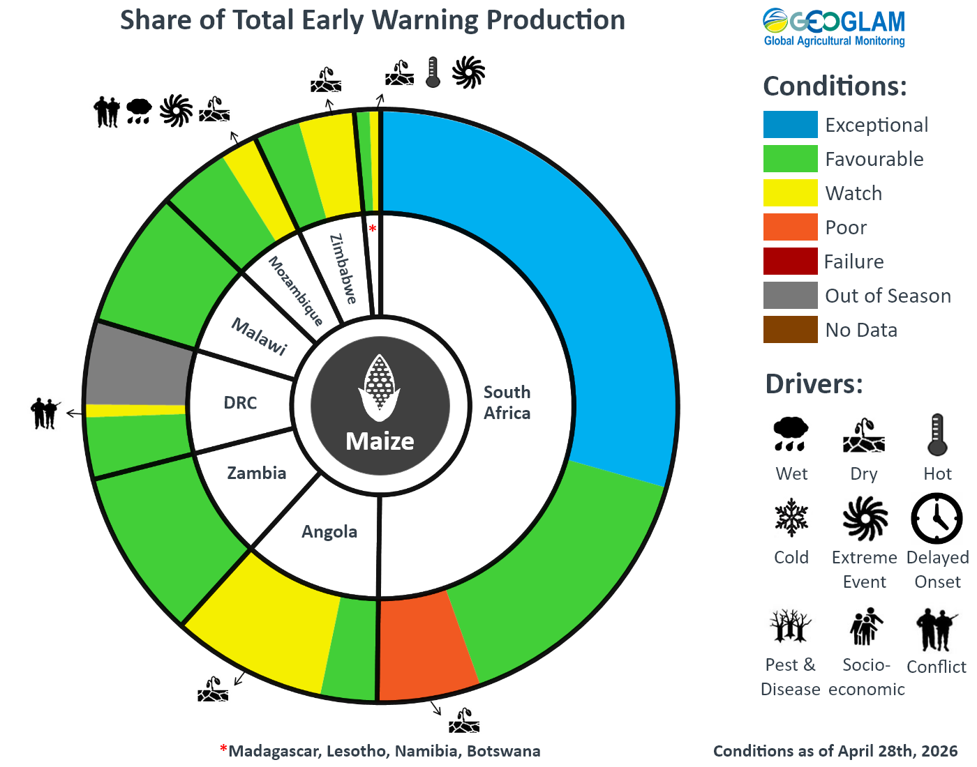
For detailed description of the pie chart please see description box on the bottom of the page.
Central & South Asia
Crop condition map synthesizing wheat conditions as of April 28th. Crop conditions over the main growing areas are based on a combination of inputs including remotely sensed data, ground observations, field reports, national, and regional experts. Crops that are in other than favourable conditions are labeled on the map with their driver.
In Central & South Asia, harvesting of Rabi season wheat crops is just beginning in Pakistan, while winter wheat crops continue to develop across southern Kazakhstan, Kyrgyzstan, Tajikistan, Uzbekistan, Turkmenistan, and Afghanistan, and conditions remain favourable for ongoing crop development. Additionally, planting of spring wheat is now underway across southern Kazakhstan, Kyrgyzstan, Tajikistan, Afghanistan, and Mongolia, and early season conditions are favourable.
In Afghanistan, consecutive years of drought and persistent high temperatures were followed by rainfall delays of up to two months for the start of the 2025/26 season, which negatively impacted winter rainfed wheat establishment. However, a shift to near-average precipitation from December 2025 through April 2026 resulted in significant soil moisture improvements and supported the grain-filling and maturity stages in March and April, particularly in the rainfed belt. Most areas received below-average cumulative precipitation from October 2025 through April 2026, though some localized areas received average to above-average amounts. Conversely, some areas received widespread intense precipitation during late March to early April that resulted in localized flooding. Dry conditions returned in mid-April, and below-average precipitation is forecast through mid-May. The area under winter wheat decreased due to erratic precipitation received from October to December 2025. Conversely, the area under spring wheat increased, and planting was supported by widespread, timely, and geographically well-distributed rains received in late March to early April, according to field reports. The total area under wheat this season is near normal. Conditions are favourable for both irrigated and rainfed wheat, and the overall wheat harvest is expected to be near normal. All basins have below-average snow water equivalent (SWE) levels, except in a couple of basins during February and March. This will pose a concern for the second season crop (rice, maize, and cotton), as an expected decline in surface water will increase groundwater extraction. Snow water volume (SWV) levels are mixed as rainfall received in late March to early April resulted in normal levels in some basins, while others show below-normal levels, particularly in the northeast. This year, longer cold spots throughout the season resulted in a delay in the wheat harvest by around two weeks. Harvesting of early-sown wheat is underway in the central highlands and higher elevations of the northeast, and the timing of remaining harvesting activities will depend on location and elevation and will extend through August and early September in some Central Highland areas. In Pakistan, harvesting of Rabi season wheat is underway, and overall conditions are favourable. The wheat harvest is estimated between 29 and 29.3 million tonnes, which is near average but slightly below last year due to production constraints in the Barani areas, where dry weather earlier in the season resulted in some crop losses. Land preparation for the maize season is underway, and crop performance will depend on the June to September monsoon performance. The expected El Niño could result in a weak and slow onset, which could negatively impact crop outcomes. However, flooding will likely not be as much of an issue compared to strong La Niña years.
Southeast Asia
Crop condition map synthesizing rice conditions as of April 28th. Crop conditions over the main growing areas are based on a combination of inputs including remotely sensed data, ground observations, field reports, national, and regional experts. Crops that are in other than favourable conditions are labeled on the map with their driver.
In southern Southeast Asia, wet-season rice is in the harvesting stage, and yield is expected to be favourable due to sufficient sunlight during the growing period. Additionally, the area of wet-season maize is estimated to have decreased from the previous season. Harvesting of wet-season maize is ongoing, and yield is expected to remain favourable with adequate irrigation water and sunlight during the growing period. Furthermore, planting of dry-season rice is underway with stable irrigation water supply.
In northern Southeast Asia, the total planted area of dry-season rice is expected to decrease slightly compared to the last season. April is the peak month of dry-season rice harvesting, and the overall yield is expected to be favourable due to adequate weather conditions and consistent water supply. However, ongoing conflict in Cambodia resulted in decreased production due to a decline in the planted area, particularly in the northwest. Additionally, dry-season maize is currently in the harvesting stage, and harvesting work is expected to finalize over the next month. The overall yield and production are expected to increase compared with the previous season, supported by adequate irrigation throughout the growing season. Furthermore, sowing of wet-season rice has started in southern Viet Nam.
Elsewhere in Southeast Asia, including Sri Lanka, Nepal, and Bangladesh, crops remain under mixed conditions, with recent heavy rains impacting Boro season rice in northeastern Bangladesh.
In Indonesia, April is the fourth month of wet-season rice harvesting, with an estimated harvested area of 4.5 million hectares, which is slightly lower than last year. Yields are expected to be favourable, supported by adequate irrigation and sufficient sunlight during the flowering period. Additionally, April is the fourth month of wet-season maize harvesting, with a total harvested area of 1.03 million hectares, which is 3.8 percent lower than the previous season. The yield is expected to remain favourable due to adequate irrigation water and sufficient sunlight during the growing period. April is also typically the start of dry-season rice planting. However, the planted area remains relatively small at about 0.9 million hectares. Planted crops are in the vegetative and early generative stages and are growing well due to adequate irrigation. Additionally, April is the first month of dry-season maize seeding, with a total sown area of 0.2 million hectares. Growing conditions are generally favourable due to sufficient irrigation water. In Malaysia, harvesting of wet-season rice is nearing completion, with 97 percent of the planted area harvested, and conditions remain favourable. Additionally, most wet-season maize fields are currently at the reproductive to grain-filling stages, while some later-planted areas remain at the early reproductive stage. Crop conditions are generally favourable, supported by adequate residual soil moisture from earlier rainfall, and overall maize production prospects remain stable. Furthermore, planting of dry-season rice is ongoing, with overall progress reaching 47 percent of the target area. Overall weather conditions and irrigation water supply remain stable and are supporting crop development. However, forecast below-normal rainfall in parts of Peninsular Malaysia and Sarawak may increase the risk of localized dry conditions. In Brunei, harvesting of wet-season rice is nearing completion in irrigated areas, with a current yield of 3.4 metric tons per hectare, while harvesting in rainfed areas is 80 percent complete. The final yield of wet-season rice is expected to be favourable. Planting of dry-season rice has just started, with 10 percent of the irrigated areas in the transplanting stage and the remaining area in the land preparation and seeding stage. The country is currently experiencing high solar radiation and low precipitation, though the overall cropping outlook remains favourable.
Crop condition map synthesizing maize conditions as of April 28th. Crop conditions over the main growing areas are based on a combination of inputs including remotely sensed data, ground observations, field reports, national, and regional experts. Conditions that are other than favourable are labeled on the map with their driver.
In the Philippines, dry-season rice planted from November to December 2025 is now in the harvesting stage, with more than half the planted area harvested. Yield is expected to be 4.06 metric tons, representing a 0.7 percent decrease from the previous year. However, growing conditions are generally favourable. Additionally, dry-season maize planted from November to December 2025 is in the harvesting stage. Yield is expected to be 3.77 metric tons, representing a 1.3 percent increase from the previous year. Growing conditions for dry-season maize are generally favourable. In Thailand, the planted area of dry-season rice is estimated at 1.96 million hectares, representing a 3 percent decrease compared to last year. Crops are currently in the grain-filling and harvesting stages. As of April, around 70 percent of the planted area has been harvested. Total production of dry-season rice is expected to decline, mainly due to a reduction in the planted area. However, yields are expected to improve slightly, supported by adequate weather conditions during the growing period. Additionally, the planted area of dry-season maize is estimated at 93,400 hectares, representing a 3.8 percent increase compared to last year. Dry-season maize crops are currently in the harvesting stage, and the cumulative harvested area reached 92 percent of the total planted area as of April. Total production is estimated at 5 million tons. Both maize yield and production are currently expected to increase compared with last year, supported by adequate irrigation throughout the growing season and the use of high-quality seed varieties. In northern Viet Nam, dry-season (winter-spring) rice is in the tillering to early panicle initiation stages. Yield prospects are favourable, supported by conducive weather conditions and improved irrigation availability. Additionally, dry-season maize is in the reproductive stage, and conditions have improved from the previous month as adequate rainfall is supporting normal crop development. In the south, dry-season (winter-spring) rice is being harvested. As of April, 0.6 million hectares have been harvested out of the total 1.9 million hectares planted, and the average yield is estimated at 6.9 tons per hectare. Additionally, dry-season maize is in the vegetative stage under favourable conditions. Furthermore, sowing of wet-season (summer-autumn) rice is underway along the Mekong Delta, with a planted area of 0.18 million hectares. In Laos, dry-season rice is in the grain filling to early harvesting stage. The harvested area reached 25 percent of the planted area, which is around 98 thousand hectares. The harvesting work is progressing faster than last year and is expected to finalize in May. Adequate irrigation water and conducive weather have supported harvesting. The production is expected to be about 443 thousand tons with an average yield of 4.5 tons per hectare, representing a slight decrease compared to last year. Additionally, dry-season maize is in the mid-harvesting stage, and about 62 percent of the planted area of 9.7 thousand hectares has been harvested. Overall maize growing conditions are favourable due to adequate soil moisture from late February rainfall. However, some areas are experiencing localized pest problems and rainfall shortages, which may affect yields in specific areas. Harvesting work is progressing faster than the previous year and is expected to finalize by the end of May. Dry-season maize production is expected to be 50 thousand tons, with an average yield of 5.06 tons per hectare, representing a slight increase compared to last year. In Myanmar, the planted area of dry-season rice is nearing completion with 1.05 million hectares, accounting for 92 percent of the national plan, and planted area is similar to last year. Over 450 thousand hectares of dry-season rice have been harvested, mainly in the delta region, with a favourable yield of 5.47 tons per hectare. Additionally, the sown area of dry-season maize reached 88.6 percent of the national target, which is less than the sown area of the previous year. Harvesting of dry-season maize finalized in April, and adequate weather conditions during the growing season supported favourable crop development. The final yield is reported at 4.5 tons per hectare, which is higher than last year. In Cambodia, dry-season rice is in the harvesting stage, and the final harvested area is expected to be 30 thousand hectares, representing an 8 percent decline compared to last year. Production is also expected to decrease by over 7 percent compared to last year due to a decline in the planted area related to ongoing conflict, particularly in the northwest. However, overall yield is expected to remain favourable. Additionally, harvesting of dry-season maize reached more than 90 percent of the total cultivated area. The yield is 6.0 tons per hectare, representing a slight increase compared to last year due to stable weather conditions. Furthermore, wet-season rice is in the field preparation stage, and planting will begin in May based on rainfall outcomes.
In Sri Lanka, planting of Yala season rice (40 percent of annual rice output) and Yala season maize (10 percent of annual maize output) is just beginning under favourable agro-climatic conditions. Following damage from Cyclone Ditwah, the government approved support for replanting efforts for affected field crops, fruits, vegetables, and minor export crops. The country is also experiencing prolonged and intensifying heat conditions, and high temperatures are expected to persist through at least mid-May. Related water shortages may result in reduced agricultural output. Additionally, the pricing and availability of fertilizer are an emerging concern for the upcoming Yala (April to October) and Maha (October to March) seasons and could result in reduced agricultural output. In Nepal, harvesting of winter wheat continues, while planting of main season maize and spring season rice is underway. Overall conditions are favourable, and crops in the west have recovered from recent drier than normal conditions. In Bangladesh, harvesting of winter (Rabi) season maize and Rabi season wheat finalized in April under favourable conditions. Harvesting of Boro season rice (55 percent of annual rice output) is just beginning with concern in parts of the northeast as recent heavy rainfall resulted in flooding in the haor (wetland) regions of Sylhet, Sunamganj, Moulvibazar, Habiganj, Netrokona, and Kishoreganj districts, and multiple rivers are at or above pre-monsoon danger levels. According to the Department of Agricultural Extension, 58 percent of farmers have harvested the paddy crop in the haor region, which comprises 20 percent of total Boro season rice production, and 17 percent of standing crops remain at risk of flooding. Harvesting activities are stalled in affected areas due to labour shortages and waterlogged fields that prevent machinery use. Elsewhere, harvesting prospects are favourable. Additionally, planting of summer (Kharif) season maize (15 percent of annual maize production) and Aus season rice (10 percent of annual rice production) continues under favourable conditions. In the Democratic People’s Republic of Korea, winter wheat and barley broke dormancy in March and are now in the very early stage of growth. Maize plantings began in April under drier than normal conditions, particularly in the north, including areas of Pyongan Bukto, Pyongan Namdo, and Hamgyng Namdo, which received 50 percent of normal rainfall in March. Water trucks are being dispatched to rural areas to improve irrigation of large crop fields. However, it is too early to detect whether this had any impact on crop conditions.
For detailed description of the pie chart please see description box on the bottom of the page.
Central America & Caribbean
Crop condition map synthesizing maize conditions as of April 28th. Crop conditions over the main growing areas are based on a combination of inputs including remotely sensed data, ground observations, field reports, national, and regional experts. Conditions that are other than favourable are labeled on the map with their driver.
In Central America, land preparation for the Primera season maize and bean crops is underway across Honduras, El Salvador, and Nicaragua, and planting is just beginning in Guatemala with concern for the start of the season due to erratic rains and high daytime temperatures recorded in 2026 that have intensified vegetation dryness. In addition, forecasts indicate elevated risks of below-normal rainfall in Central America and the Caribbean during May to July due to the forecast El Niño and warming trends in the region, heightening concerns for the 2026 Primera season crops (See Regional Outlook Pg. 17). Dry conditions would likely affect sowing activities for small and subsistence farmers and irrigation availability for large farmers. Furthermore, some farmers will reduce the application of agrochemicals due to increased international costs of fertilizers and pesticides. Even if normal rains are received, there will likely be negative implications for yields and market prices due to reduced agrochemical application.
In Honduras, harvesting of second season rice finalized in April, while planting of main season rice is just beginning, and overall rice conditions are favourable. However, erratic and below-average rainfall received in early 2026 continued through March and is expected to intensify during the Primera season (See Regional Outlook Pg. 17). A combination of irregular and below-average rainfall and high temperatures is expected to result in a prolonged canícula dry spell and accelerated soil‑moisture loss. These conditions may constrain Primera planting and early development, particularly for subsistence farmers in Dry Corridor areas without irrigation access.
In Haiti, main season rice is in the vegetative to reproductive stage, while planting of Printemps season beans continues. Above-average rainfall since the start of the Printemps season in March and early April is supporting normal crop development, irrigation availability, and generally average to above-average vegetation conditions. Artibonite, the main rice-growing area, received good rains that enabled sowing. However, prolonged insecurity continues to restrict access to land and agricultural labour, limiting income opportunities, and input access also remains limited due to high prices and logistical constraints. As a result of these challenges, farmers may reduce cultivated areas. In Cuba, harvesting of second season maize finalized in April while harvesting of second season rice crops (1/3 of annual rice production) is just beginning. Additionally, planting of main season rice is now underway. Despite generally favourable agro-climatic conditions, second season rice yields are expected to be below average, and there is concern for ongoing harvesting and planting activities as the country has faced a severe reduction in fuel availability since January, affecting electricity generation, transportation, and essential logistics. Due to the rise in international oil prices, the government raised the price of domestic fuel, leading to higher transportation and distribution costs and exacerbating the pressure on already high fuel prices. In Pinar del Rio, there is evidence of rotting crops in the fields and crops not being timely processed and transported to markets.
Seasonal Forecast Alert: Elevated chances of below-average rainfall and above-average temperatures
Below-average rainfall is forecast for late April to early May 2026 in portions of Central America and in the Caribbean. Below-average rainfall and above-average temperatures will likely occur throughout the next 6 months, based on seasonal climate model forecasts raising concerns for Primera season crops. During April 1st to April 25th there were minor rainfall deficits in portions of central Guatemala, northern Honduras, western El Salvador, and eastern Nicaragua. In Haiti, southern, central and northeastern areas were wetter than average. El Salvador experienced a heat wave during mid-April.
Rainfall forecasts for late April and into early May indicate that rainfall deficits may develop regionally during coming weeks. Several sub seasonal forecasts point to below-average rainfall conditions during late April to early May in southern-central Guatemala, El Salvador, Honduras, western Nicaragua, and the Caribbean. There is low confidence in the severity of impacts, due to model differences, nevertheless the below average and erratic rainfall distribution is affecting the usual SOS over many areas of Central America, especially in small and subsistence farmers of basic grains, due to the good rainfall performance in Haiti during March and early April favor a normal development of crops.. The ECMWF forecast from April 29th indicates that drier-than-average conditions could continue into mid-May. An early season rainfall anomaly outlook, which includes the 15-day forecast from April 26th and preliminary data for earlier weeks, indicates that April 1st to May 10th rainfall totals may be 25 mm to 50 mm below average across much of northern Central America and 50 to 100 mm below average in western and central-northern Guatemala, El Salvador, and western Honduras (Figure 1 middle-left). The early season rainfall amounts and distribution and forecast above-normal temperatures could lead to slow gains in soil moisture and some farmers may delay planting Primera season crops.
There will be elevated risks of below-normal rainfall in Central America and the Caribbean during May to September 2026, and beyond. This means that multiple cropping seasons could potentially experience adverse dry and hot weather conditions this year, during the 2026 Primera, Printemps, and Segunda rainfall seasons. These hazards are indicated by multiple seasonal climate forecasts, including ECMWF and NMME forecasts (Figure 1 middle-right), WMO, and C3S multi-model ensembles. Based on April initial condition forecasts, there are greater-than 50 percent chances of below-normal May to July (MJJ) 2026 rainfall in southern and eastern Guatemala, El Salvador, Honduras, Nicaragua, and central-southern Caribbean areas. Models showed more agreement (60 to 70 percent chances) of below-normal MJJ 2026 rainfall in Central America’s Pacific coast regions and in Haiti. Longer-range NMME rainfall forecasts are pessimistic through November 2026. Models are highly confident (greater than 80 percent chances) that regional temperatures during the next six months will be much warmer than normal. Higher temperatures speed the evaporation of soil moisture, and increase risks of crop stress during dry spells and from pests and disease, early appearance of pests has been reported over areas of Central America.
Expectations of El Niño conditions are the main driver of these outlooks. Warming trends in the region also contribute to the high odds of hotter-than-normal temperatures. El Niños tend to have a regional drying influence, though events can have variable impacts. During nine past years when El Niño was active during June to September (JJAS), historical rainfall data show that JJAS precipitation totals were below-normal more often in Guatemala, El Salvador, western and central Honduras, western Nicaragua, and Haiti, while drying influences were less common in eastern areas of both Honduras and Nicaragua (Figure 1 right). The NOAA CPC April 2026 official ENSO outlook predicts 61 percent chances of El Niño criteria being met during May to July 2026, and ~90 percent chances from August 2026 to January 2027.
The 2026 Atlantic Hurricane season will likely be less active than normal due to the El Niño event, according to the Colorado State University Extended Range Forecast. Associated with that forecast are lower chances of hurricane landfall in the Caribbean.
Figure 1. Recent rainfall anomaly and a forecast-based outlook, rainfall probability forecast for May to July 2026, and historical June to September rainfall during El Niño events. Left and middle-left: CHC Early Estimates, which show preliminary and preliminary + forecast rainfall for April 1st to 25th, 2026, and April 1st to May 10th, 2026, respectively. Estimated differences from the 1996-2025 average, for each time period, are shown in both. These use CHIRPS3 data. A bias-adjusted NCEP GEFS forecast (CHIRPS3-GEFS) is used for the 15-day forecast from April 26th. Middle-right: Multi-model ensemble forecast for the probability of below-normal, normal, and above-normal May to July 2026 rainfall, based on April initial conditions, ECMWF and 6 NMME models, and a 1991-2020 baseline of model hindcasts. NMME data is from the IRI Data Library; ECMWF data is from Copernicus. Right: The frequency of below-normal June-to-September rainfall during years with concurrent El Niño conditions (1982, 1987, 1991, 1994, 1997, 2002, 2004, 2015, 2023), relative to 1991-2020 CHIRPS3 terciles. In areas with orange to dark red colors, below-normal rains occurred in four to nine years (40 to 100%). From UCSB CHC. Source: UCSB Climate Hazards Center
Pie Chart Description: Each slice represents a country’s share of total regional production. The proportion within each national slice is colored according to the crop conditions within a specific growing area; grey indicates that the respective area is out of season. Sections within each slide are weighted by the sub-national production statistics (5-year average) of the respective country. The section within each national slice also accounts for multiple cropping seasons (i.e. spring and winter wheat) and are a result of combining totals from multiple seasons to represent the total yearly national production. When conditions are other than favourable icons are added that provide information on the key climatic drivers affecting conditions.
Information on crop conditions in the main production and export countries can be found in the Crop Monitor for AMIS, published May 7th, 2026.
Sources and Disclaimers: The Crop Monitor assessment is conducted by GEOGLAM with inputs from the following partners FEWS NET, JRC, WFP, ARC, AFSIS, MESA, ICPAC, FAO GIEWS, Applied Geosolutions and UMD. The findings and conclusions in this joint multi-agency report are consensual statements from the GEOGLAM experts, and do not necessarily reflect those of the individual agencies represented by these experts.