Global Crop Monitor
Report Information
No. 42: Published April 2nd 2026
Conditions as of March 28th
To access all reports, please visit the Archive.
Please visit the Referencing Guidelines page for information on how to cite the Crop Monitor reports and products.
Synthesized from the Crop Monitor for AMIS, the Crop Monitor for Early Warning, and direct submissions from individual countries.
Crop conditions over the main growing areas are based on inputs, including remotely sensed data, ground observations, field reports, and national and regional experts. Regions in conditions other than favourable are labelled on the map with a symbol representing the crop(s) affected.
Global Crop Overview
Global crop conditions at the end of March remain generally positive for wheat, maize, rice, and soybeans. For wheat, conditions are overall favourable, albeit with some areas of concern in North America, Europe, the Middle East and North Africa, and East Africa. For maize, global conditions are generally favourable; however, areas of dryness persist in western Argentina, Uruguay, and parts of Sub-Saharan Africa. For rice, overall conditions are favourable; however, there are some concerns in Cambodia, Sri Lanka, the Caribbean, and in parts of Sub-Saharan Africa. For soybeans, conditions are generally favourable in the Southern Hemisphere as harvesting continues in Brazil. The remaining crops are detailed in the CM4EW publication.
Global Climate Influences Overview
La Niña conditions were present during March 2026. Neutral ENSO conditions are expected during April and May, with El Niño likely to develop shortly after. According to the March 2026 NOAA CPC ENSO outlook, El Niño criteria will likely be met during June to August 2026 (62 percent chance), and the event will persist through the end of 2026 (83 percent chance for October to December 2026). El Niño events can have widespread, global impacts, including a likely warming effect on global temperatures.
For further details on the Global Climate Influences and Regional Climate Outlooks section.
WHEAT
Wheat crop conditions over the main growing areas are based upon a combination of national and regional crop analyst inputs, along with earth observation data. Conditions are based upon information as of March 28th.
In North America, concerns persist in the US for winter wheat due to persistent drought and exposure to earlier and recent cold weather. Spring wheat sowing is beginning in the Pacific Northwest. In Canada, winter wheat continues in mixed conditions as winter moisture remains insufficient across most areas. In Mexico, the autumn-winter season crop is under favourable conditions. In Europe, winter wheat in the EU has resumed vegetative growth under mostly favourable conditions; however, there are concerns in Spain due to waterlogging and in the Baltic states and Poland due to below-average rainfall. In the UK, conditions are favourable for the crop as spring regrowth begins. In Türkiye, conditions are favourable for winter wheat. In Ukraine, winter wheat has resumed regrowth earlier than normal due to the warm weather in March. Low soil moisture levels in the south are a developing concern. In the Russian Federation, winter wheat has broken dormancy in the south and is under favourable conditions. In Central Asia, winter wheat continues to develop in Kyrgyzstan, Tajikistan, Uzbekistan, and Turkmenistan under favourable conditions. In Kazakhstan, winter wheat conditions are favourable. Sowing of spring wheat is now underway in Kyrgyzstan and Afghanistan under favourable conditions. In South Asia, the harvest in India is in the early stages under generally favourable conditions despite recent unseasonal rain and hail damage in several northern states. In Pakistan, a sufficient supply of irrigation water has resulted in favourable vegetation conditions in the main wheat-growing areas. Additionally, recent rains have mitigated concerns regarding prior dry conditions in the northern rainfed Barani areas. In Bangladesh, conditions are favourable as harvesting begins. In Nepal, harvesting is just beginning. In East Asia, winter wheat is out of dormancy in China, and spring wheat sowing is beginning. In MENA, the early-season dry conditions negatively impacted planting activities and crop emergence in many areas and continue to cause concern in northwestern Algeria, northwestern Libya, northwestern Syria, and parts of Iran. In parts of southeastern Iraq, crop biomass is below average due to a government decision to limit the area of cultivation using surface water. Conversely, in northeastern Morocco, some areas were negatively affected by flooding in March. In Egypt, conditions are favourable, with a large increase in total sown area compared to last year due to government support. In Sub-Saharan Africa, winter wheat harvesting in Sudan is just beginning, and ongoing insecurity continues to diminish production capacity. In Tanzania, erratic rains between November 2025 and January 2026 negatively impacted crop conditions.
For detailed description of the pie chart, please see box on the bottom of the page.
MAIZE
Maize crop conditions over the main growing areas are based upon a combination of national and regional crop analyst inputs, along with earth observation data. Conditions are based upon information as of March 28th.
In South America, the harvesting in Brazil of the spring-planted crop (smaller season) is ongoing under favourable to exceptional conditions, especially in the South Region. Sowing of the summer-planted crop (larger season) is wrapping up with an increase in total sown area compared to last season. In Argentina, the harvest of early-planted crops (larger season) continues under mixed conditions due to variability in early rainfall. The late-planted crops (smaller season) are in the grain-filling stages under favourable conditions supported by recent rainfall. In Uruguay, the harvest for the early-season crop is wrapping up with below-average yields as the late-season crop is still in the grain-filling stage. In Central America & the Caribbean, conditions are favourable in Mexico for the autumn-winter season (smaller season), albeit with a reduction in total sown area compared to last year. In Cuba, harvesting of second-season maize is just beginning under oil shortages, which have resulted in power and water supply disruptions. In Haiti, sowing for the Printemps season is beginning under mixed conditions. In North America, earlier than normal sowing in the US is beginning in parts of the southeast region. In South Asia, the harvest in India for the Rabi crop (smaller season) is ongoing under favourable conditions. In Sri Lanka, harvesting of the Maha season crop (larger season) is wrapping up under mixed conditions due to the impacts of Cyclone Ditwah. In Bangladesh, the harvest for the Rabi/winter crop is ongoing. In Nepal, sowing of the main season maize continues. In Southeast Asia, the sowing of the wet-season crop in Indonesia wraps up, as harvesting of earlier sown crops continues. In Malaysia, conditions are favourable. Dry-season maize is harvesting in Cambodia, Myanmar, the Philippines, and Thailand, while the crop continues to develop in Laos. In Viet Nam, sowing of dry-season maize continues in the north and begins in the south. In East Africa, sowing in Ethiopia of the Belg/main season crop is just beginning. In Kenya, harvesting of short rains maize is wrapping up under poor to failure conditions. In Tanzania, sowing and development of the main season crop continues, and while erratic rains have impacted the Msimu season crops. Sowing is beginning across Burundi, Rwanda, Uganda, and Kenya. In West Africa, sowing of the main season crops is now underway in Liberia, Côte d’Ivoire, Ghana, Togo, Benin, Nigeria, Cameroon, and the Central African Republic. In Southern Africa, there is concern in parts of central and eastern Madagascar regarding the recent impacts of tropical cyclones, while dry concerns remain present in parts of northwestern Angola, east and southern Madagascar, and across Zimbabwe. In South Africa, favourable to exceptional conditions continue across most provinces, supported by earlier, timely rains.
For detailed description of the pie chart, please see box on the bottom of the page.
RICE
Rice crop conditions over the main growing areas are based upon a combination of national and regional crop analyst inputs, along with earth observation data. Conditions are based upon information as of March 28th.
In East Asia, sowing has begun in China for early double-crop rice (smallest season). In Central & South Asia, the harvest in India is beginning for the Rabi crop as sowing wraps up for the Summer crop. In Bangladesh, the Boro crop (largest season) is under favorable conditions. Sowing of the Aus crop (smallest season) is beginning. In Sri Lanka, harvesting of the Maha season crop (largest season) is wrapping up with concerns due to the damage caused by Cyclone Ditwah. In Nepal, sowing of second-season rice is beginning under favourable conditions. In Southeast Asia, harvesting of wet-season rice in Indonesia continues with good yields due to sufficient water and sunlight during the growing period. In Malaysia, the harvest is ongoing for wet-season rice as sowing begins for dry-season rice. In Brunei, harvesting of wet-season rice is progressing. In Vietnam, conditions are favorable as winter-spring (dry-season) rice harvest begins in the south, and sowing continues in the north. In Thailand, dry-season rice is in the grain-filling and harvesting stages, with yields expected to improve compared to last season. In the Philippines, dry-season rice conditions are favorable as crops sown in November and December are starting to be harvested. In Myanmar, sowing of dry-season rice is continuing under favourable conditions, with harvesting of earlier-planted crops beginning in the Delta region. In Cambodia, harvesting of dry-season rice is continuing. In Laos, sowing of dry-season rice has wrapped up. In the Americas, the harvest in Brazil is progressing under favourable conditions. In Uruguay, harvesting is ongoing under favourable conditions. In Mexico, the autumn-winter crop is under favourable conditions. In Cuba, the second-season rice crop is being negatively impacted by the limited availability of fuel and water supply. In Honduras, harvesting of second-season rice is nearing completion under favourable conditions. In Haiti, harvesting of second-season rice is wrapping up under mixed conditions due to overly wet weather. In Sub-Saharan Africa, harvesting of second-season rice continues in Mali under poor conditions due to conflict. In Kenya, the sowing of second-season rice continues under favourable conditions. In Tanzania, conditions are mixed due to erratic rains between November 2025 and January 2026. In Mozambique, conditions are favourable despite widespread flooding in the south and central areas. In Madagascar, conditions are mixed due to dryness across most of the country.
For detailed description of the pie chart, please see box on the bottom of the page.
SOYBEAN
Soybean crop conditions over the main growing areas are based upon a combination of national and regional crop analyst inputs, along with earth observation data. Conditions are based upon information as of March 28th.
In South America, the harvest in Brazil is proceeding slightly ahead of normal under favorable conditions. In the Central-West region, conditions are exceptional due to mostly good weather throughout this season. In Argentina, rainfall across much of the agricultural area has improved crop conditions for both the early-planting crop (larger season), which is nearing harvest, and the late-planted crop (smaller season), which is in a critical growth stage. In Uruguay, harvesting is beginning for the early-planted crop under mixed conditions due to prolonged dry weather. The late-planted crop is under favourable conditions, potentially partially compensating for lower early-planted yields. In Africa, conditions are favourable to exceptional in South Africa, with good yields expected across most provinces. An increase in total sown area is estimated compared to last year and the five-year average.
For detailed description of the pie chart, please see box on the bottom of the page.
Pie Chart Description: Each slice represents a country's share of total Global production (5-year average). Main producing countries (representing 90-95 percent of production) are shown individually, with the remaining 5-10 percent grouped into the “Smaller Producing Countries” category. The proportion within each national slice is coloured according to the crop conditions within a specific growing area; grey indicates that the respective area is out of season. Sections within each slide are weighted by the sub-national production statistics (5-year average) of the respective country. The section within each national slice also accounts for multiple cropping seasons (e.g., spring and winter wheat). When conditions are other than ‘favourable’, icons are added that provide information on the key climatic drivers affecting conditions.
Global Climate Influences
La Niña conditions were present during March 2026. Neutral ENSO conditions are expected during April and May, with El Niño likely to develop shortly after. According to the March 2026 NOAA CPC ENSO outlook, El Niño criteria will likely be met during June to August 2026 (62 percent chance), and the event will persist through the end of 2026 (83 percent chance for October to December 2026). While long-range forecasts made at this time of year can be unreliable, El Niño events can have widespread, global impacts, including a likely warming effect on global temperatures.
Abnormally hot temperatures occurred during March 2026 in portions of western and eastern Australia, El Salvador, western and central India, southern Madagascar, northwestern Mexico, South Africa, and the southwestern United States. During late March through mid-April 2026, above-average temperatures are forecast in South Africa, the eastern Sahel region, southern-central South America, across central, northern, and eastern Asia, western Australia, northern Mexico, and the United States. Below-average temperatures are forecast in northern Africa, central and eastern Canada, and the Middle East.
Source: UCSB Climate Hazards Center
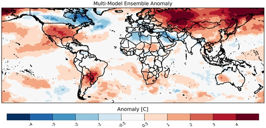
Average temperature anomaly forecast for the next 30 days starting on 26 March 2026, from four Subseasonal Consortium (SubC) models. SubC data accessed from the IRI Data Library. Map source: UCSB Climate Hazards Center.
Regional Outlooks
Both the short-term (2 weeks) and the long-term (3 months) forecasts reflect the warming global temperatures, while the long-term forecast reflects the potential switch from La Niña to El Niño.
In North America, the two-week forecast (Figures 1 & 2) indicates a likelihood of above-average precipitation over the southern and northern Midwest of the US, and northeastern and southwestern Mexico, while below-average precipitation over northeastern Canada, the western US. During the same time, temperatures are likely to be above-average over most of the central and eastern US, central and northeastern Mexico, while likely below-average over central and northeastern Canada. The long-term April-May-June 2026 forecast (Figures 3 & 4) indicates a likely above-average precipitation over central Mexico. During the same time, temperatures are likely to be above-average over the entire region, with the highest likelihood over most of the US and Mexico. For additional details, see the CM4AMIS Regional Outlook for the USA.
In Central America & the Caribbean, the two-week forecast (Figures 1 & 2) indicates a likelihood of above-average precipitation over eastern Nicaragua, Costa Rica, and eastern Panama. During the same period, temperatures are likely to be above-average over parts of southern Cuba, central Costa Rica, and eastern Panama. The long-term April-May-June 2026 forecast (Figures 3 & 4) suggests a leaning towards below-average precipitation over Haiti, the Dominican Republic, Honduras, El Salvador, Nicaragua, Costa Rica, and Panama. During this time, temperatures are highly likely to be above-average over most of the region. For additional details, see the CM4EW Regional Outlook for Central America and the Caribbean.
Figure 1: IRI SubX Precipitation Biweekly Probability Forecast for 4-17 April, issued on 27 March 2026. The forecast is based on statistically calibrated tercile category forecasts from three SubX models. Source: IRI Subseasonal Forecasts Maproom
In South America, the two-week forecast (Figures 1 & 2) indicates likely above-average precipitation over northern Colombia, Venezuela, northern Guyana, northern Suriname, northern French Guiana, southwestern Peru, northern Chile, and northeastern Brazil, while below-average precipitation over central Bolivia, Paraguay, southern and southeastern Brazil, northern Argentina, and central Chile. During this time, temperatures are likely to be above-average over western Colombia, Ecuador, western and southern Peru, southern and northern Bolivia, the majority of Brazil, Paraguay, northern and central Chile, and northern and central Argentina, and Uruguay, while below-average over central Venezuela. The long-term April-May-June 2026 forecast (Figures 3 & 4) suggests a leaning towards above-average precipitation over central and eastern Colombia, Ecuador, eastern Peru, and eastern Bolivia, while a leaning towards below-average precipitation over western Colombia. During that time, temperatures are likely to be above-average over most of the region except for northeast Brazil and northern Venezuela.
In Europe, the two-week forecast (Figures 1 & 2) indicates likely above-average over southern Italy, eastern Serbia, southwestern Romania, Bulgaria, North Macedonia, Greece, and western and southern Türkiye, while below-average precipitation over Ireland, the United Kingdom, northern Portugal, northwestern Spain, France, Switzerland, Belgium, the Netherlands, western Germany, Denmark, southern Norway, central Sweden, Finland, Estonia, Latvia, northern Belarus, the northwestern Russian Federation, northwestern Romania, eastern Hungary, and Slovakia. During this time, temperatures are likely to be above-average over the northern United Kingdom, Norway, Sweden, Finland, and northern Estonia, while below-average over southwestern Ukraine, Romania, Bulgaria, North Macedonia, Greece, and southern Türkiye. The long-term April-May-June 2026 forecast (Figures 3 & 4) indicates no major leaning toward either above or below-average precipitation. During the same period, temperatures are likely to be above-average over Europe, with the highest likelihood over Italy, Austria, Hungary, Slovakia, Belarus, Ukraine, Romania, Croatia, Slovenia, Bosnia and Herzegovina, Serbia, Albania, Kosovo, North Macedonia, Bulgaria, Greece, Türkiye, Georgia, Armenia, Azerbaijan, and the southern and western Russian Federation.
Figure 2: IRI SubX Temperature Biweekly Probability Forecast for 4-17 April, issued on 27 March 2026. The forecast is based on statistically calibrated tercile category forecasts from three SubX models. Source: IRI Subseasonal Forecasts Maproom
In MENA, the two-week forecast (Figures 1 & 2) indicates a likelihood of above-average precipitation over northern Syria, northern and western Iraq, northeastern and southwestern Iran, Qatar, the United Arab Emirates, eastern Oman, western Yemen, central Saudi Arabia, Jordan, northern and central Egypt, northern Libya, and northern Algeria, while below-average precipitation is likely over northcentral Saudi Arabia. During this time, temperatures are likely to be below-average over central Algeria, Tunisia, Libya, central Egypt, Jordan, Syria, Iraq, northern and eastern Saudi Arabia, and southeastern Iran. The long-term April-May-June 2026 forecast (Figures 3 & 4) indicates a leaning towards above-average precipitation over Syria, Iraq, Jordan, Saudi Arabia, Yemen, Oman, and Iran. During this time, temperatures are likely to be above-average over the entire region, except for western Morocco.
In Sub-Saharan Africa, the two-week forecast (Figures 1 & 2) indicates likely above-average precipitation over Burkina Faso, northern Ghana, Togo, Benin, Nigeria, southern Chad, northern Cameroon, the northern Central African Republic, southern Sudan, northern South Sudan, northwestern Ethiopia, northwestern Angola, central South Africa, central Mozambique, and northeastern Tanzania, while below-average precipitation over southern Ethiopia, southern Somalia, Kenya, Uganda, southern South Sudan, Rwanda, Burundi, northern Tanzania, and northern Madagascar. During this time, temperatures are likely to be above-average over Guinea, southwest Côte d'Ivoire, northern Nigeria, southwest Cameroon, Equatoria Guinea, Gabon, the southern Republic of the Congo, southern Sudan, northern and southeast Ethiopia, Somalia, Kenya, Uganda, western Tanzania, Malawi, central and northern Mozambique, southern Zambia, southeastern Angola, Namibia, Botswana, Zimbabwe, South Africa, Lesotho, Eswatini, and southern Madagascar. For the long-term April-May-June 2026 forecast (Figures 3 & 4), precipitation is likely to be above-average over southern Chad, central Cameroon, the Central African Republic, and southwest Sudan. During this time, temperatures are likely to be above-average over Mauritania, Mali, eastern Senegal, eastern Guinea, Sierra Leone, Liberia, Burkina Faso, Côte d'Ivoire, Ghana, Togo, Benin, northern Niger, northern Chad, Sudan, South Sudan, the Central African Republic, Cameroon, southern Nigeria, Somalia, Equatorial Guinea, Gabon, Republic of the Congo, the Democratic Republic of the Congo, northeastern Angola, northern Mozambique, Madagascar, and southern South Africa. For additional details, see the CM4EW regional outlooks for East Africa and Southern Africa.
Figure 3: Based on September conditions, a probability forecast for the most likely April-May-June (AMJ) 2026 rainfall tercile. The white colour indicates that there is no dominant category across the model forecasts. Source: WMO Lead Centre for Long-Range Forecast Multi-Model Ensemble
In Central Asia, the two-week forecast (Figures 1 & 2) indicates likely above-average precipitation over southern Kazakhstan, Uzbekistan, western Kyrgyzstan, western Tajikistan, eastern Turkmenistan, and Afghanistan. During this time, temperatures are likely to be above-average over most of Kazakhstan, Kyrgyzstan, Tajikistan, eastern Uzbekistan, eastern Turkmenistan, and northeastern Afghanistan. The long-term April-May-June 2026 forecast (Figures 3 & 4) does not indicate a leaning towards either above or below-average precipitation for the region. At the same time, temperatures are likely to be above-average over Kyrgyzstan, Tajikistan, western Turkmenistan, and northern Afghanistan.
In South Asia, the two-week forecast (Figures 1 & 2) indicates likely above-average precipitation over Pakistan, western and northcentral India, Nepal, Bangladesh, while below-average precipitation over Sri Lanka. During this time, temperatures are likely to be above-average over northern Pakistan, northwestern and southeastern India, northern Nepal, and Bhutan, while below-average over Bangladesh and northeastern India. The long-term April-May-June 2026 forecast (Figures 3 & 4) indicates leaning towards above-average precipitation over northern Pakistan, while a leaning towards below-average precipitation over Bangladesh and northeastern India. During this time, temperatures are likely to be above-average over coastal Pakistan, coastal and northeastern India, and Sri Lanka. For additional details, see the CM4AMIS Regional Outlook for India.
In East Asia, the two-week forecast (Figures 1 & 2) indicates likely above-average precipitation over southern China and the northeastern Russian Federation, while below-average precipitation is likely over northern Mongolia, northwestern and northeastern China, the Democratic People's Republic of Korea, and southern and northern Japan. During this time, temperatures are likely to be above-average over the entire region. The long-term April-May-June 2026 forecast (Figures 3 & 4) indicates a likelihood of above-average precipitation over central-west China, while below-average precipitation over parts of southeastern China and western Mongolia. During that time, temperatures are likely to be above-average over most of the region except for northeastern China.
In Southeast Asia & Oceania, the two-week forecast (Figures 1 & 2) indicates likely below-average precipitation over the Philippines, southern Viet Nam, Cambodia, Thailand, eastern Myanmar, Malaysia, northern and eastern Indonesia, Papua New Guinea, and northern and eastern Australia. During this time, temperatures are likely to be above-average over most of the region except for central Indonesia, northern and southern Australia, and New Zealand. The long-term April-May-June 2026 forecast(Figures 3 & 4)indicates likely below-average precipitation over Myanmar, southern Thailand, Malaysia, Indonesia, and Papua New Guinea, and southern Australia. During the same time, temperatures are likely to be above-average over Myanmar, western and southern Thailand, the southern Philippines, Malaysia, central Indonesia, northern Papua New Guinea, and southern New Zealand, while likely below-average temperatures over northern Australia.
Figure 4: Based on January conditions, a probability forecast for the most likely April-May-June (AMJ) 2026 temperature tercile. The white colour indicates that there is no dominant category across the model forecasts. Source: WMO Lead Centre for Long-Range Forecast Multi-Model Ensemble