
Global Crop Monitor
Report Information
No. 49: Published November 5th 2026
Conditions as of October 28th
To access all reports, please visit the Archive.
Please visit the Referencing Guidelines page for information on how to cite the Crop Monitor reports and products.
Synthesized from the Crop Monitor for AMIS, the Crop Monitor for Early Warning, and direct submissions from individual countries.
Crop conditions over the main growing areas are based on inputs, including remotely sensed data, ground observations, field reports, and national and regional experts. Regions in conditions other than favourable are labelled on the map with a symbol representing the crop(s) affected.
Global Crop Overview
Global crop conditions at the end of October are generally positive for wheat, maize, rice, and soybeans. Wheat conditions are generally favourable as harvesting begins in the Southern Hemisphere and winter wheat sowing progresses in the Northern Hemisphere. Maize conditions are generally favourable, though yields are poor in Europe, parts of East Africa, and the US. Rice conditions are generally favourable; however, adverse weather is negatively impacting crops in parts of Southeast Asia. Soybean harvesting is ongoing in the Northern Hemisphere, with good yields expected in the US, poor yields in Europe, and mixed outcomes in India. Sowing is ongoing in Brazil. The CM4EW publication discusses the remaining crops.
Global Climate Influences Overview
Strong El Niño conditions are present and strengthening. The event will likely be very strong and rank among the strongest since 1950. El Niño conditions are forecast through April 2027 (98% chance). A positive Indian Ocean Dipole (IOD) event is underway and forecast through December.
During late October through early November 2026, abnormally hot temperatures are forecast in active crop development areas of southern and eastern Mexico, Central America, Haiti, central Brazil, southern West Africa, Sudan, Somalia, Tanzania, Zambia, Zimbabwe, northern Mozambique, northern South Africa, Pakistan, western and southern India, and parts of Southeast Asia.
For further details on the Global Climate Influences and Regional Climate Outlooks section.
WHEAT
Wheat crop conditions across the main growing areas are based on a combination of national and regional crop analyst inputs and earth observation data. Conditions reflect information as of October 28th.
In North America, the 2026/2027 winter wheat sowing in the US is progressing, with recent rains easing drought in parts of the Central and Southern Plains. In Canada, winter wheat sowing is beginning under favourable conditions. In Europe, sowing of the 2026/2027 crop is ongoing across the EU under contrasting conditions, with drought hampering crop emergence across southern and central Europe, while excess rainfall delays sowing in the Baltic states. In Ukraine, conditions are favourable for the 2026/2027 winter wheat crop, though development is slightly behind normal due to late sowing. The total sown area is expected to be lower than last year. In the Russian Federation, conditions are favourable as sowing of the 2026/2027 winter wheat crop has caught up after some initial delays. In the United Kingdom, sowing is continuing under dry conditions. In Türkiye, winter wheat sowing is ongoing under favourable conditions. In Central Asia, the spring wheat harvest has finished across Kyrgyzstan and Tajikistan under favourable conditions, despite earlier concerns about dryness. In Kazakhstan, spring wheat harvesting is wrapping up under favourable conditions as winter wheat sowing begins in the south. Sowing of the 2026/27 winter wheat season has started in parts of Kyrgyzstan, Pakistan, Tajikistan, Turkmenistan, and Uzbekistan under favourable conditions. In MENA, winter wheat sowing is ongoing under favourable conditions in Iran. In Algeria, sowing has started with well-below-average rainfall across the west and, to a lesser extent, in the east. In Tunisia, sowing is beginning with below-average rainfall, with about a 50% deficit in the last month. In Libya, sowing is underway, with good rainfall in the west and near-average in the east. In Sub-Saharan Africa, harvest is beginning in South Africa under favourable conditions over the interior. However, dry weather from June to August has negatively affected the Western Cape and parts of KwaZulu-Natal, reducing yields. Total sown area is much lower than last year. In Lesotho, Zambia, and Zimbabwe, harvest is underway under favourable conditions. In Ethiopia and Kenya, conditions are poor due to prolonged drought. In Oceania, harvesting in Australia is ongoing, with above-average yields expected in South Australia and Victoria, while Queensland expects below-average yields. In South America, conditions are favourable in Argentina as harvesting is beginning in the north. In Brazil, harvesting is progressing. Heavy rainfall and hail events in the south are cause for concern. Total sown area is down compared to last year. In Uruguay, conditions are favourable. In Chile, conditions are poor due to ongoing heavy rainfall and waterlogged soils.
For detailed description of the pie chart, please see box on the bottom of the page.
MAIZE
Maize crop conditions across the main growing areas are based on a combination of national and regional crop analyst inputs and earth observation data. Conditions reflect information as of October 28th.
In South America, sowing of the spring-planted crop (smaller season) in Brazil is progressing, with the total sown area expected to be higher than last season. In Argentina, sowing is progressing for the early-planted crop (larger season) under favourable conditions. In Central America & the Caribbean, early hot, dry weather in Mexico is affecting the spring-summer crop (larger season). Sowing is underway for the Segunda/Postrera season in Guatemala, El Salvador, Honduras, and Nicaragua under mixed conditions due to extended dry spells and high temperatures. In Cuba, the main-season crop is being harvested. In Haiti, sowing of the Été season crops is continuing. In North America, the US harvest is ongoing under mostly favourable to exceptional conditions. In Canada, harvesting is beginning, with good yields expected in Ontario, the main producing province. In Europe, the harvest is wrapping up in the EU with generally below-average yields due to hot, dry weather throughout the season. In Ukraine, the harvest is slowly progressing, with mixed yields expected due to drought and high temperatures in the western regions. In the Russian Federation, harvesting is continuing, with good yields expected. In Türkiye, the harvest is finishing. In South Asia, the Kharif crop (larger season) harvest in India is progressing under mixed conditions due to a below-average Southwest Monsoon. In Pakistan, conditions are favourable as harvesting progresses. In Sri Lanka, Yala season harvesting is wrapping up as Maha season sowing begins. In East Asia, harvesting is wrapping up in China for both the spring-maize crop (larger season) and the summer-maize crop (smaller season). In Southeast Asia, harvesting continues in Indonesia for the dry-season crop as the wet-season crop begins to be sown. In Malaysia, harvesting continues for dry-season crops, as wet-season sowing continues. The wet-season crop is favourable in Cambodia, Lao PDR, Myanmar, and Viet Nam. In Thailand, wet-season crop harvesting is ongoing under mixed conditions due to hot, dry weather. In the Philippines, heavy rains and strong winds have reduced yield expectations. In East Africa, harvest is underway in Ethiopia (Meher season), unimodal regions in Kenya, and South Sudan under poor conditions. Sowing of second-season crops is underway in Burundi, Kenya, Tanzania, and Rwanda under mixed conditions due to recent dryness. In Somalia, sowing is underway for the Deyr season, and above-average rains have impacted crops. In West Africa, harvesting of main-season crops is underway in Guinea, Sierra Leone, Liberia, Côte d’Ivoire, Ghana, northern Togo, northern Benin, northern Cameroon, and the Central African Republic. Second-season maize continues to develop in Côte d’Ivoire, Ghana, Togo, Benin, Nigeria, and Cameroon.
For detailed description of the pie chart, please see box on the bottom of the page.
RICE
Rice crop conditions across the main growing areas are based on a combination of national and regional crop analyst inputs and earth observation data. Conditions reflect information as of October 28th.
In East Asia, harvesting in China continues for single-season rice (largest season) and late double-crop rice (medium season) under favourable conditions. In Japan, harvesting is finishing under favourable conditions. In the Republic of Korea, harvesting is wrapping up. In the DPRK, the harvest is wrapping up under favourable conditions. In Central & South Asia, Kharif harvesting in India is progressing in the northern states, while the crop continues to develop in the eastern and southern states. In Bangladesh, conditions are favourable for the Aman (medium-season) crop. In Pakistan, the Kharif season rice harvest is ongoing under favourable conditions. In Sri Lanka, the Yala season crop harvest is ending as sowing of the Maha season crop begins. In Nepal, conditions are favourable for the main-season crop. In Southeast Asia, dry-season rice harvesting in Indonesia continues, and sowing for wet-season rice is beginning. In Malaysia and Brunei, dry-season rice harvesting ends as sowing for wet-season rice progresses. In Viet Nam, wet-season rice harvesting is underway in the north, where flooding and waterlogging during earlier growth stages have adversely affected yields. In the south, the harvest is finishing for summer-autumn rice (wet-season rice), while harvesting begins for autumn-winter rice and seasonal rice. In Thailand, drought and recent flooding have adversely affected wet-season rice yields. Total sown area is lower than last year. In the Philippines, wet-season rice harvesting is ongoing under mixed conditions due to heavy rains and strong winds from the enhanced southwest monsoon and tropical cyclones. In Myanmar, sowing continues for wet-season rice as harvesting begins for earlier sown crops. In Cambodia, harvesting has begun as flooding and earlier drought damage crops. In Laos, wet-season rice harvesting has begun. In the Americas, harvesting is wrapping up in the US. In Brazil, sowing is continuing. In Mexico, conditions are favourable for the Spring-Summer crop, with total sown area up from last year. In Cuba, main-season rice sowing is advancing. In Haiti, main-season rice harvesting is ongoing. In MENA, conditions are favourable across Egypt, Iraq, and Iran. In Sub-Saharan Africa, conditions are favourable in West Africa; however, conflict remains a negative factor in the Sahel areas of Mali and Nigeria. Conditions are favourable in Kenya.
For detailed description of the pie chart, please see box on the bottom of the page.
SOYBEAN
Soybean crop conditions across the main growing areas are based on a combination of national and regional crop analyst inputs and earth observation data. Conditions reflect information as of October 28th.
In North America, the harvest is progressing in the US, with above-average yields expected in parts of the central Corn Belt and along the East Coast. In Canada, the harvest is advancing under favourable conditions, with total sown area up compared to last year and the average. In Mexico, conditions are mixed due to earlier dry weather, with a large increase in sown area compared to last year. In Europe, conditions are poor in the EU as the harvest finishes. High temperatures and dry weather during the season negatively impacted crops. In Ukraine, the harvest is finishing, with yields expected to be below average because precipitation was below-average and temperatures were above-average during the season. In the Russian Federation, the harvest is completing under favourable to exceptional conditions due to good rains throughout the season, particularly in the south. In South America, sowing in Brazil is just progressing under favourable conditions, with an estimated slight increase in total area compared to last season. In Asia, harvesting is wrapping up in China under favourable conditions. In India, the harvest continues under mixed conditions because of long dry spells from a below-average Southwest Monsoon. In Africa, conditions are mostly favourable in Nigeria, except in the northern regions due to the ongoing conflict and socio-economic issues.
For detailed description of the pie chart, please see box on the bottom of the page.
Pie Chart Description: Each slice represents a country's share of total Global production (5-year average). Main producing countries (representing 90-95 percent of production) are shown individually, with the remaining 5-10 percent grouped into the “Smaller Producing Countries” category. The proportion within each national slice is coloured according to the crop conditions within a specific growing area; grey indicates that the respective area is out of season. Sections within each slide are weighted by the sub-national production statistics (5-year average) of the respective country. The section within each national slice also accounts for multiple cropping seasons (e.g., spring and winter wheat). When conditions are other than ‘favourable’, icons are added that provide information on the key climatic drivers affecting conditions.
Global Climate Influences
Strong El Niño conditions are present and strengthening. The event will likely be very strong from September 2026 to January 2027 (>96% chance, according to the October 2026 NOAA ENSO outlook) and rank among the strongest since 1950. El Niño conditions are forecast through April 2027 (98% chance).
El Niño events tend to enhance rainfall in parts of Asia (Central Asia, southwestern Asia, and eastern China), southern North America, southeastern South America, and eastern and southern East Africa. Drier-than-average conditions tend to occur across Central America, northern South America, Southern Africa, the Maritime Continent, and western and northern Australia.
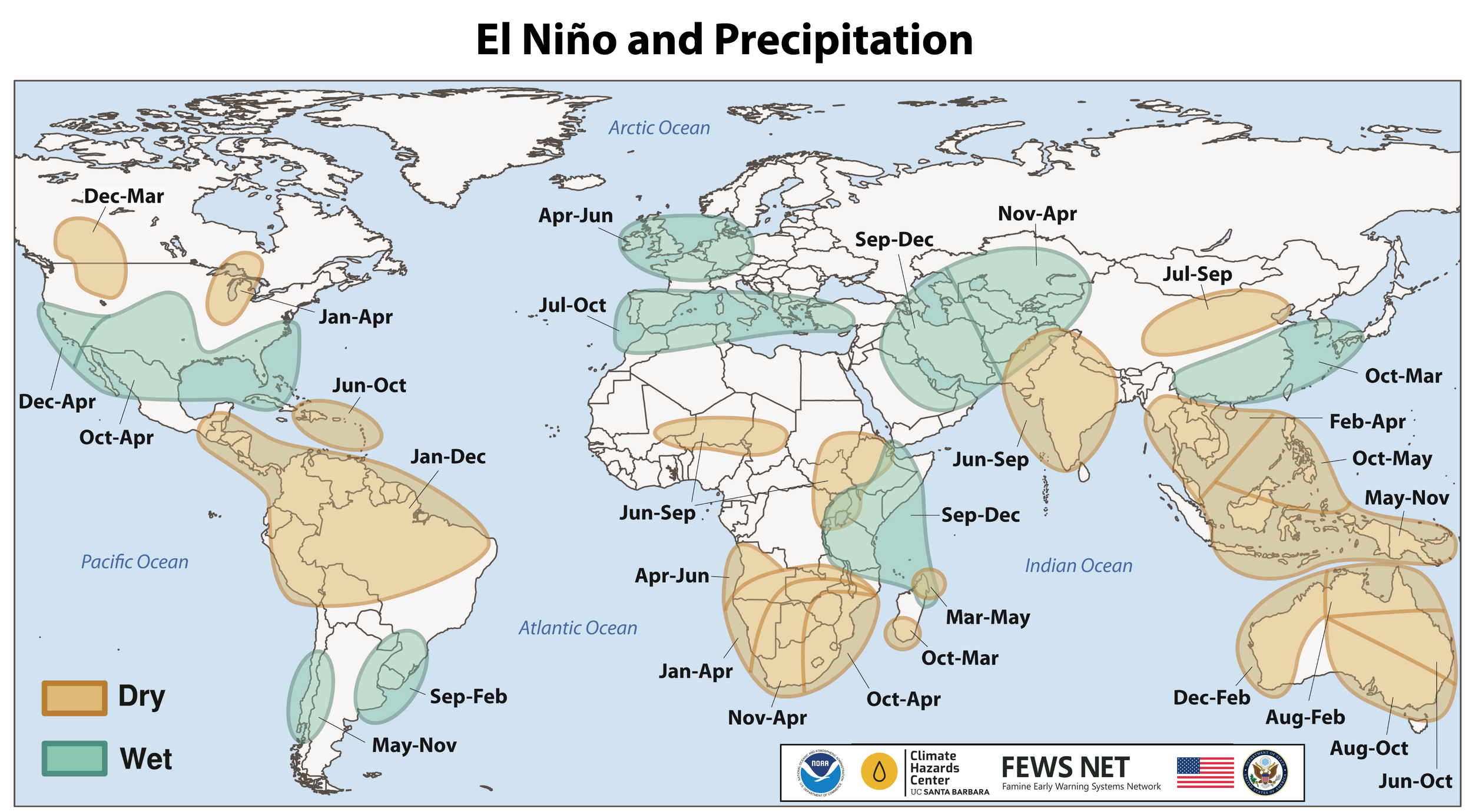
Location and timing of likely above- and below-average precipitation related to El Niño events. Based upon observed precipitation during 22 El Niño events since 1950, wet and dry correspond to a statistically significant increase in the frequency of precipitation in the upper and lower thirds of historical values, respectively. Statistical significance at the 95% level is based on the resampling of precipitation during neutral El Niño-Southern Oscillation conditions. Source: FEWS NET & NOAA & CHC
A positive Indian Ocean Dipole (IOD) event is underway. IOD index values from the Bureau of Meteorology have ranged from +0.88 to +0.69 in recent weeks. Positive IOD conditions are forecast through December. A positive IOD typically enhances the drying influence of El Niño in Australia and the Maritime Continent and increases the chances of an above-average East Africa short rains season.
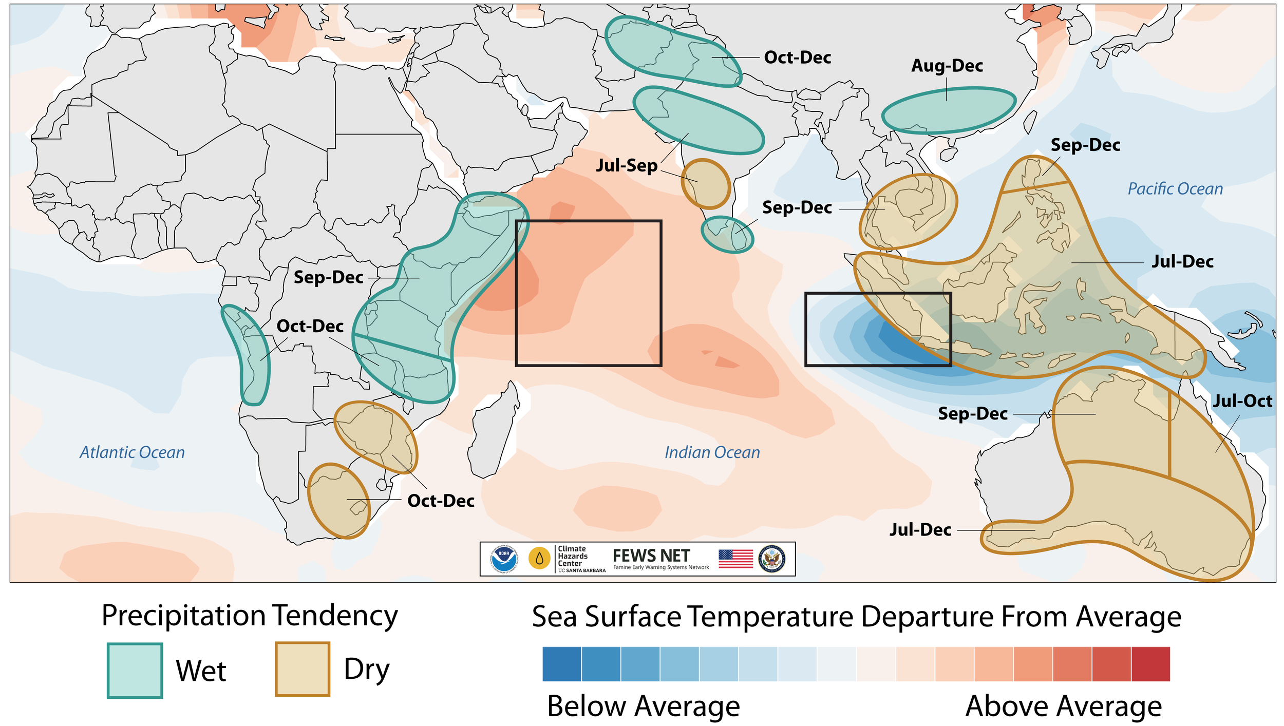
The timing of wet and dry conditions based on Climate Research Unit, CHIRPS, and Global Precipitation Climatology Centre precipitation (green and brown polygons), and sea surface temperature departures from average during July September (blue and red shading), related to the IOD. The regions used to define the Dipole Mode Index are outlined in black.
September 2026 was the second-warmest September for global temperatures. Annual average temperatures for 2026 may be similar to 2024, the current warmest year on record, according to the Copernicus Climate Change Service Climate Bulletin. The very strong El Niño will continue to increase the likelihood of extreme conditions.
During late October through early November 2026, abnormally hot temperatures are forecast in active crop development areas of southern and eastern Mexico, Central America, Haiti, central Brazil, southern West Africa, Sudan, Somalia, Tanzania, Zambia, Zimbabwe, northern Mozambique, northern South Africa, Pakistan, western and southern India, and parts of Southeast Asia.
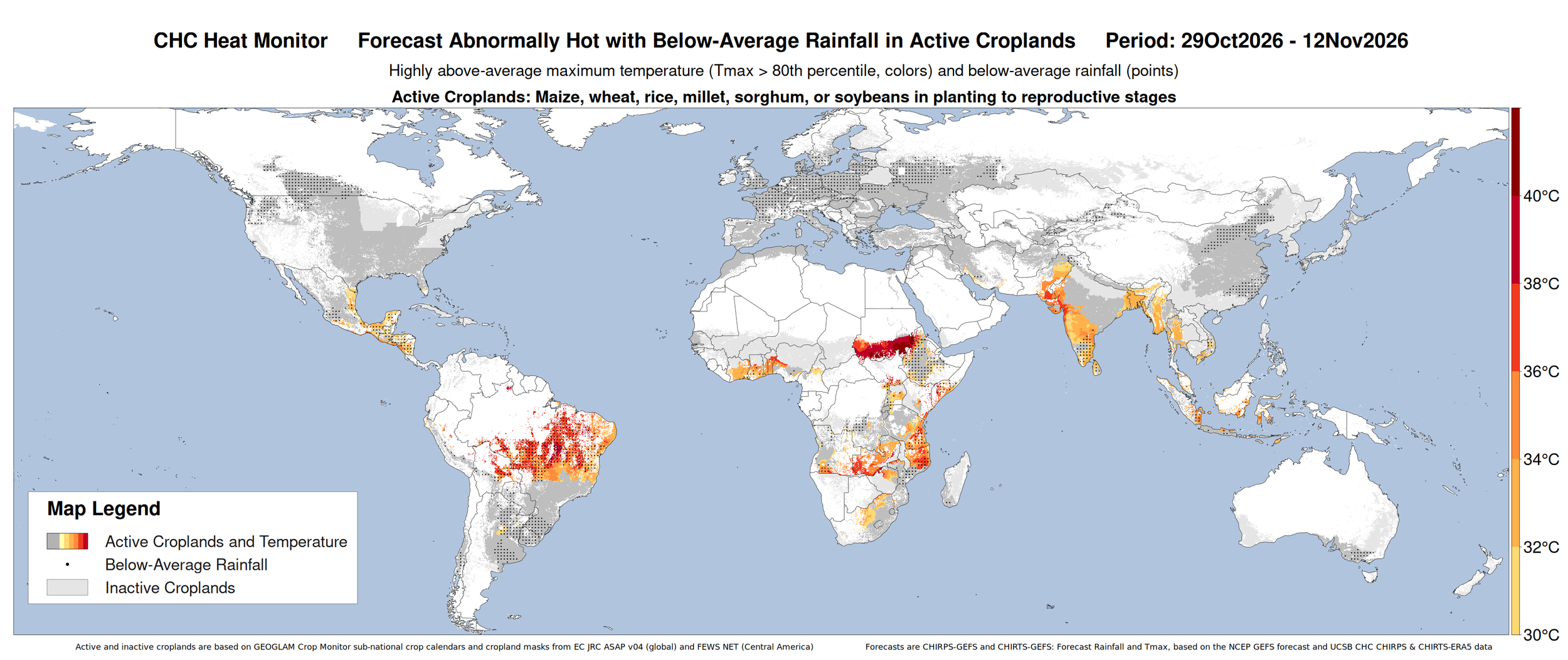
CHC AgriHeat Forecast for October 29 to November 12, 2026. Forecast 15-day average maximum temperatures are shown where they will be abnormally hot (Tmax > 80th percentile and > 30 C) and in active crop-growing areas. Areas with forecasted below-average rainfall for this period are also identified. Based on a 15-day CHIRTS-GEFS forecast from June 26, 2026. From UCSB Climate Hazards Center. Map source: UCSB Climate Hazards Center
Source: UCSB Climate Hazards Center
Regional Outlooks
Both the short-term (2 weeks) and long-term (3 months) forecasts reflect warming global temperatures, along with current El Niño and positive IOD conditions.
In North America, the two-week forecast (Figures 1 & 2) indicates a likelihood of above-average precipitation over the western and southern US. In contrast, below-average precipitation is likely over Canada and the northern US. During the same period, temperatures are likely to be above average over Canada and the northern US. The long-term November-December-January 2026/27 forecast (Figures 3 & 4) suggests likely above-average precipitation over southwestern, central, and eastern US, while likely below-average precipitation over western Canada and the northern Rockies in the US. During the same period, temperatures are likely above-average over Canada and the northern US. For additional details, see the CM4AMIS Regional Outlook for the USA.
In Central America & the Caribbean, the two-week forecast (Figures 1 & 2) indicates a likelihood of above-average precipitation over Cuba. In contrast, below-average precipitation is likely over southern Mexico, southern Guatemala, El Salvador, western Nicaragua, Costa Rica, Panama, Haiti, and the Dominican Republic. During the same period, temperatures are likely to be above-average over northwestern and southern Mexico, Guatemala, El Salvador, southern Honduras, Nicaragua, Costa Rica, Panama, Cuba, southern Haiti, and the southern Dominican Republic, while below-average temperatures are likely over western Mexico. The long-term November-December-January 2026/27 forecast (Figures 3 & 4) suggests likely above-average precipitation over Mexico, Cuba, northern Haiti, and the northern Dominican Republic, while likely below-average precipitation over the rest of the region. During the same period, temperatures are highly likely to be above-average over most of the region except northern Mexico.
Figure 1: IRI SubX Precipitation Biweekly Probability Forecast for 7 – 20 November 2026, issued on 30 October 2026. The forecast is based on statistically calibrated tercile category forecasts from three SubX models. Source: IRI Subseasonal Forecasts Maproom
In South America, the two-week forecast (Figures 1 & 2) indicates likely above-average precipitation over western Ecuador, southern Peru, southeast Brazil, central Chile, and central west Argentina. In contrast, below-average precipitation is likely over Colombia, Venezuela, Guyana, Suriname, French Guiana, eastern Ecuador, northern and eastern Peru, northern Bolivia, northern Brazil, and southern Chile. During the same period, temperatures are likely to be above-average over most of the region except southern Brazil, Uruguay, and southeastern Argentina. The long-term November-December-January 2026/27 forecast (Figures 3 & 4) suggests likely above-average precipitation over western Ecuador, western Peru, south and southeastern Brazil, eastern Paraguay, Uruguay, central Chile, and northeastern and southern Argentina, while below-average precipitation over northern Colombia, Venezuela, Guyana, Suriname, French Guiana, northern Brazil, eastern Peru, Bolivia, and northwestern Argentina. During the same period, temperatures are highly likely above-average across most of the region, while below-average temperatures are likely in central Argentina and Uruguay.
In Europe, the two-week forecast (Figures 1 & 2) indicates likely above-average precipitation over Portugal, western Spain, northwestern France, southeastern Poland, southern Belarus, eastern Ukraine, Albania, Greece, Türkiye, Georgia, Armenia, and the southern and central Russian Federation. In contrast, below-average precipitation is likely over the northern UK, western Norway, and central Finland. During the same period, temperatures are likely to be above-average over Portugal and Spain, while temperatures are likely to be below-average over Germany, southern Sweden, southern Finland, Poland, Czechia, eastern Austria, Slovakia, Hungary, Romania, western Ukraine, Belarus, northern Türkiye, and the western Russian Federation. The long-term November-December-January 2026/27 forecast (Figures 3 & 4) indicates likely above-average precipitation across most of the region except for southern Europe and northern Norway. During the same period, temperatures are very likely to be above-average over most of the region, with the highest likelihood over central and western Europe. For additional details, see the CM4AMIS Regional Outlook for Europe.
Figure 2: IRI SubX Temperature Biweekly Probability Forecast for 3 – 16 October 2026, issued on 25 September 2026. The forecast is based on statistically calibrated tercile category forecasts from three SubX models. Source: IRI Subseasonal Forecasts Maproom
In MENA, the two-week forecast (Figures 1 & 2) indicates a likelihood of below-average precipitation over Syria, northern Iraq, central west Iran, southwestern Algeria, and western Morocco. In contrast, below-average precipitation is likely over southern Iran. During the same period, temperatures are likely above-average over most of the region except Egypt, northern and central Iraq, Syria, and Jordan. The long-term November-December-January 2026/27 forecast (Figures 3 & 4) indicates likely above-average precipitation over Jordan, Syria, Iraq, Iran, Saudi Arabia, Yemen, and Oman, while likely below-average over Morocco, northern Algeria, Tunisia, and northwestern Libya. During the same period, temperatures are likely to be above-average across the region.
In Sub-Saharan Africa, the two-week forecast (Figures 1 & 2) indicates likely above-average precipitation over western Tanzania, northeastern Zambia, Malawi, northern Mozambique, Madagascar, central Namibia, while below-average precipitation is likely over Guinea-Bissau, southern Ghana, northeastern Nigeria, northern Cameroon, southern Chad, northern and western Gabon, the northern Republic of the Congo, northwestern Angola, northern Democratic Republic of the Congo, South Sudan, Ethiopia, Uganda, western and northern Kenya, Somalia, and eastern Tanzania. During the same period, temperatures are likely to be above-average over most of the region except the Central African Republic, the central Republic of Congo, the Democratic Republic of the Congo, southern Uganda, Rwanda, Burundi, western Tanzania, Zambia, Angola, northern Namibia, and western Madagascar. For the long-term November-December-January 2026/27 forecast (Figures 3 & 4), precipitation is likely to be above-average over Mauritania, Mali, Senegal, the Gambia, Guinea-Bissau, Guinea, northern Côte d'Ivoire, northern Ghana, Burkina Faso, Niger, Togo Benin, Nigeria, northern Cameroon, Chad, Sudan, South Sudan, Eritrea, Ethiopia, Somalia, Kenya, Uganda, the Democratic Republic of the Congo, Rwanda, Burundi, and northern Tanzania, while precipitation is likely to be below-average over southern Angola, Zambia, Zimbabwe, Mozambique, Madagascar, Botswana, Namibia, South Africa, Lesotho, and Eswatini. During the same period, temperatures are highly likely to be above-average across the entire region. For additional details, see the CM4EW regional outlooks for East Africa and Southern Africa.
Figure 3: Probabilistic forecast for November-December-January 2026/27 precipitation, based on October initial conditions. Probabilities are based on C3S multi-system seasonal forecasts from ECMWF as part of the Copernicus Programme.
In Central Asia, the two-week forecast (Figures 1 & 2) indicates likely above-average precipitation over western and southern Kazakhstan, eastern Uzbekistan, western Kyrgyzstan, western Tajikistan, eastern Turkmenistan, and northern Afghanistan. During the same period, temperatures are likely to be above-average over most of the region except western Kazakhstan and western Uzbekistan. The long-term November-December-January 2026/27 forecast (Figures 3 & 4) indicates likely above-average precipitation over most of the region. During the same period, temperatures are likely to be above-average over most of the region, with the highest likelihood over southern Kazakhstan, Kyrgyzstan, Tajikistan, and Afghanistan. For additional details, see the CM4EW regional outlooks for Central and Southern Asia.
In South Asia, the two-week forecast (Figures 1 & 2) indicates likely above-average precipitation over northeastern India and eastern Bangladesh, while below-average precipitation over southern India and Sri Lanka. During the same period, temperatures are likely to be above-average over Pakistan, western and southern India, northern Bangladesh, and Sri Lanka, while temperatures are likely to be below-average over northern Nepal, Bhutan, and eastern India. The long-term November-December-January 2026/27 forecast (Figures 3 & 4) indicates likely above-average precipitation over northern and western Pakistan, northwestern India, western Nepal, and Sri Lanka. During the same period, temperatures are likely to be above-average across the entire region.
In East Asia, the two-week forecast (Figures 1 & 2) indicates likely above-average precipitation over southern China, while below-average precipitation is likely over northern China and the eastern Russian Federation. During the same period, temperatures are likely to be above-average over western Mongolia and northwestern and central China, while temperatures are likely to be below-average over northeastern China, the northeastern Democratic Republic of Korea, and northern Japan. The long-term November-December-January 2026/27 forecast (Figures 3 & 4) indicates likely above-average precipitation across most of the region, except southwestern China. During the same period, temperatures are likely above-average across most of the region.
In Southeast Asia & Oceania, the two-week forecast (Figures 1 & 2) indicates likely above-average precipitation over Myanmar, northern and central Thailand, Laos, northern Viet Nam, Cambodia, and northeastern Australia, while below-average precipitation is likely over southern and central Indonesia, and Papua New Guinea. During the same period, temperatures are likely to be above-average over northern and eastern Myanmar, Lao PDR, Thailand, Viet Nam, Cambodia, the Philippines, Malaysia, Indonesia, northern Papua New Guinea, eastern Australia, and northern New Zealand. The long-term November-December-January 2026/27 forecast (Figures 3 & 4) indicates likely above-average precipitation over western Malaysia, western and eastern Indonesia, northern Viet Nam, northern Papua New Guinea, south-central Australia, and southern New Zealand, while likely below-average precipitation over southern Viet Nam, the Philippines, central Indonesia, and eastern Malaysia. During the same period, temperatures are likely to be above-average across most of the region except New Zealand.
Figure 4: Probabilistic forecast for November-December-January 2026/27 temperature, based on October initial conditions. Probabilities are based on C3S multi-system seasonal forecasts from ECMWF as part of the Copernicus Programme.